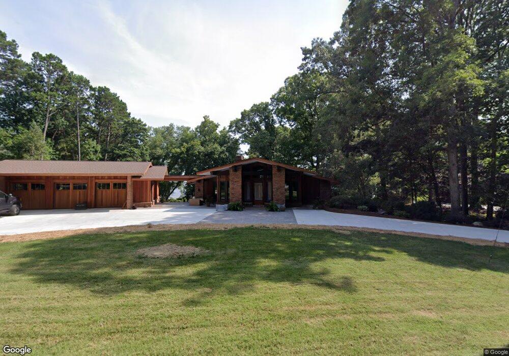
8433 Luckey Point Rd Denver, NC 28037
Estimated Value: $1,042,000 - $1,704,162
4
Beds
4
Baths
2,310
Sq Ft
$617/Sq Ft
Est. Value
About This Home
This home is located at 8433 Luckey Point Rd, Denver, NC 28037 and is currently estimated at $1,425,791, approximately $617 per square foot. 8433 Luckey Point Rd is a home located in Lincoln County with nearby schools including Catawba Springs Elementary School, East Lincoln Middle School, and East Lincoln High School.
Ownership History
Date
Name
Owned For
Owner Type
Purchase Details
Closed on
May 9, 2024
Sold by
Cline William B and Cline Ruth R
Bought by
Cline Family Living Trust and Cline
Current Estimated Value
Purchase Details
Closed on
Oct 20, 2010
Sold by
Cline William B and William B Cline Jr Family Trus
Bought by
Cline William B and Cline Ruth R
Purchase Details
Closed on
Nov 1, 2005
Sold by
Cline William B and Cline Ruth R
Bought by
Cline William B
Purchase Details
Closed on
Jan 29, 1999
Bought by
Cline William B and Cline Ruth R
Create a Home Valuation Report for This Property
The Home Valuation Report is an in-depth analysis detailing your home's value as well as a comparison with similar homes in the area
Purchase History
| Date | Buyer | Sale Price | Title Company |
|---|---|---|---|
| Cline Family Living Trust | -- | None Listed On Document | |
| Cline William B | -- | None Available | |
| Cline William B | -- | None Available | |
| Cline William B | $330,000 | -- |
Source: Public Records
Tax History
| Year | Tax Paid | Tax Assessment Tax Assessment Total Assessment is a certain percentage of the fair market value that is determined by local assessors to be the total taxable value of land and additions on the property. | Land | Improvement |
|---|---|---|---|---|
| 2025 | $8,104 | $1,318,485 | $497,790 | $820,695 |
| 2024 | $8,049 | $1,318,485 | $497,790 | $820,695 |
| 2023 | $8,049 | $1,318,485 | $497,790 | $820,695 |
| 2022 | $6,796 | $904,085 | $400,153 | $503,932 |
| 2021 | $6,841 | $753,418 | $400,153 | $353,265 |
| 2020 | $5,251 | $753,418 | $400,153 | $353,265 |
| 2019 | $5,251 | $753,418 | $400,153 | $353,265 |
| 2018 | $4,752 | $651,938 | $379,108 | $272,830 |
| 2017 | $4,564 | $651,938 | $379,108 | $272,830 |
| 2016 | $4,544 | $651,938 | $379,108 | $272,830 |
| 2015 | $4,850 | $651,938 | $379,108 | $272,830 |
| 2014 | $4,734 | $678,068 | $428,831 | $249,237 |
Source: Public Records
Map
Nearby Homes
- 8293 Luckey Point Rd
- 8056 Windsong Rd
- 8181 Bright Water Ln
- 8030 Prestwick Ln
- 987 Jerry Lees Way
- 214 Lytham Ln
- 1890 Yacht Club Dr
- 329 Bent Tree Dr
- Lot #43 Lytham Ln
- 7522 Turnberry Ln
- 7778 Burning Ridge Dr
- 7738 Burning Ridge Dr
- 18019 Harbor Light Blvd
- 535 Cowans Villa Rd Unit 6
- 18103 Harbor Light Blvd
- 8194 Mallard Rd
- 18112 Harbor Light Blvd
- 11 Serenity Cove Place
- 16318 Belle Isle Dr
- 2135 Regatta Ln Unit 101
- 8443 Luckey Point Rd
- 8399 Luckey Point Rd
- 8457 Luckey Point Rd
- 8464 Luckey Point Rd
- 8393 Luckey Point Rd
- 8412 Luckey Point Rd
- 8471 Luckey Point Rd
- 8389 Luckey Point Rd
- 8383 Luckey Point Rd
- 8350 Luckey Point Rd
- 8151 Luckey Point Rd
- 8377 Luckey Point Rd
- 8489 Luckey Point Rd
- 8181 Luckey Point Rd
- 8137 Luckey Point Rd
- 8193 Luckey Point Rd
- 13 Luckey Point Rd
- 13 Luckey Point Rd Unit 13
- 8363 Luckey Point Rd
- 8172 Waterford Dr
Your Personal Tour Guide
Ask me questions while you tour the home.