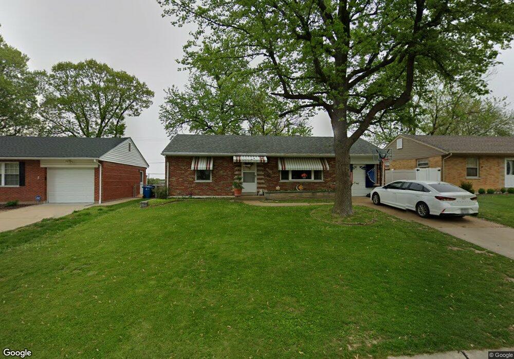
8438 Hampstead Dr Saint Louis, MO 63123
Estimated Value: $145,000 - $228,000
2
Beds
1
Bath
938
Sq Ft
$212/Sq Ft
Est. Value
About This Home
This home is located at 8438 Hampstead Dr, Saint Louis, MO 63123 and is currently estimated at $199,248, approximately $212 per square foot. 8438 Hampstead Dr is a home located in St. Louis County with nearby schools including Mesnier Primary School, Gotsch Intermediate School, and Rogers Middle School.
Ownership History
Date
Name
Owned For
Owner Type
Purchase Details
Closed on
May 23, 2024
Sold by
Subasic Damir and Subasic Emira
Bought by
Subasic Properties Llc Series 8438
Current Estimated Value
Purchase Details
Closed on
May 4, 2018
Sold by
Schisler Donald D
Bought by
Subasic Damir and Subasic Emira
Home Financials for this Owner
Home Financials are based on the most recent Mortgage that was taken out on this home.
Interest Rate
4.55%
Purchase Details
Closed on
May 28, 1997
Sold by
Wright Laverne E Revocable Trust and Mildred V
Bought by
Schisler Donald D and Schisler Sally M
Home Financials for this Owner
Home Financials are based on the most recent Mortgage that was taken out on this home.
Original Mortgage
$76,200
Interest Rate
7.98%
Mortgage Type
Assumption
Create a Home Valuation Report for This Property
The Home Valuation Report is an in-depth analysis detailing your home's value as well as a comparison with similar homes in the area
Home Values in the Area
Average Home Value in this Area
Purchase History
| Date | Buyer | Sale Price | Title Company |
|---|---|---|---|
| Subasic Properties Llc Series 8438 | -- | None Listed On Document | |
| Subasic Damir | -- | -- | |
| Schisler Donald D | -- | -- |
Source: Public Records
Mortgage History
| Date | Status | Borrower | Loan Amount |
|---|---|---|---|
| Previous Owner | Subasic Damir | -- | |
| Previous Owner | Schisler Donald D | $76,200 |
Source: Public Records
Tax History
| Year | Tax Paid | Tax Assessment Tax Assessment Total Assessment is a certain percentage of the fair market value that is determined by local assessors to be the total taxable value of land and additions on the property. | Land | Improvement |
|---|---|---|---|---|
| 2025 | $2,705 | $36,100 | $14,930 | $21,170 |
| 2024 | $2,705 | $33,270 | $9,960 | $23,310 |
| 2023 | $2,616 | $33,270 | $9,960 | $23,310 |
| 2022 | $2,657 | $28,960 | $9,960 | $19,000 |
| 2021 | $2,425 | $28,960 | $9,960 | $19,000 |
| 2020 | $2,217 | $24,680 | $9,730 | $14,950 |
| 2019 | $2,213 | $24,680 | $9,730 | $14,950 |
| 2018 | $2,147 | $21,160 | $6,780 | $14,380 |
| 2017 | $2,133 | $21,160 | $6,780 | $14,380 |
| 2016 | $1,770 | $18,620 | $5,830 | $12,790 |
Source: Public Records
Map
Nearby Homes
- 6714 Colony Acres Dr
- 8517 Ava Dr
- 8520 Ava Dr
- 8200 New Hampshire Ave
- 6527 Gramond Dr
- 8615 Charlton Ln
- 8628 Charlton Ln
- 8210 Marvale Ln
- 8016 Wynwood Dr
- 8348 Vasel Dr
- 8942 Eden Ave
- 9702 Sterling Place
- 9320 Sterling Place
- 9304 Aster Ave
- 9337 Mackenzie Rd
- 7243 General Sherman Ln
- 7837 La Belle St
- 8506 Mathilda Ave
- 6330 Hurstgreen Ln
- 6625 Hurstgreen Ln
- 8442 Hampstead Dr
- 8434 Hampstead Dr
- 8430 Hampstead Dr
- 8446 Hampstead Dr
- 8450 Hampstead Dr
- 8439 Hampstead Dr
- 8435 Hampstead Dr
- 8443 Hampstead Dr
- 8431 Hampstead Dr
- 8447 Hampstead Dr
- 8451 Hampstead Dr
- 8422 Hampstead Dr
- 8413 Hampstead Dr
- 8458 Hampstead Dr
- 8455 Hampstead Dr
- 8418 Hampstead Dr
- 8424 New Hampshire Ave
- 8420 New Hampshire Ave
- 8428 New Hampshire Ave
Your Personal Tour Guide
Ask me questions while you tour the home.