

8443 Stephenson Rd Onsted, MI 49265
Estimated payment $4,958/month
Highlights
- Lake Front
- Wooded Lot
- Cathedral Ceiling
- Deck
- Traditional Architecture
- Wood Flooring
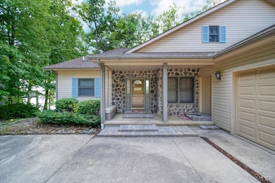
About This Home
*PLEASE DO NOT APPROACH PROPERTY WITHOUT A SCHEDULED APPOINTMENT.* Spacious lake front home offering 4,000 sq. ft of living space! With views of the gorgeous all-sports lake Loch Erin out every window! Featuring 4-bedrooms, home office, sunroom, finished basement, walk-out, dry bar and more! The garage is a MUST SEE, with the ability to fit 6 cars, and a workshop. It comes equipped with skylights, furnace, 100amp panel, and generator! Dont wait, schedule your tour today!
Home Details
Home Type
- Single Family
Est. Annual Taxes
Year Built
- Built in 2000
Lot Details
- 0.84 Acre Lot
- 130 Ft Wide Lot
- Lake Front
- Rural Setting
- Sloped Lot
- Sprinkler System
- Wooded Lot
- Garden
HOA Fees
- $13 Monthly HOA Fees
Home Design
- Traditional Architecture
- Brick Exterior Construction
- Vinyl Siding
- Vinyl Trim
Interior Spaces
- 2-Story Property
- Wet Bar
- Bar Fridge
- Cathedral Ceiling
- Ceiling Fan
- Entryway
- Family Room
- Living Room with Fireplace
- Dining Room with Fireplace
- Home Office
- Workshop
Kitchen
- Eat-In Kitchen
- Oven or Range
- Microwave
- Dishwasher
- Disposal
Flooring
- Wood
- Carpet
Bedrooms and Bathrooms
- 4 Bedrooms
- Main Floor Bedroom
- Bathroom on Main Level
Laundry
- Laundry Room
- Dryer
- Washer
Finished Basement
- Walk-Out Basement
- Basement Fills Entire Space Under The House
- Interior and Exterior Basement Entry
- Basement Window Egress
Parking
- 6 Car Attached Garage
- Heated Garage
- Garage Door Opener
Outdoor Features
- Access To Lake
- Seawall
- Balcony
- Deck
- Patio
- Porch
Utilities
- Forced Air Heating and Cooling System
- Heating System Uses Natural Gas
- Gas Water Heater
- Water Softener is Owned
Listing and Financial Details
- Assessor Parcel Number CA0-565-3290-00
Map
Home Values in the Area
Average Home Value in this Area
Tax History
| Year | Tax Paid | Tax Assessment Tax Assessment Total Assessment is a certain percentage of the fair market value that is determined by local assessors to be the total taxable value of land and additions on the property. | Land | Improvement |
|---|---|---|---|---|
| 2025 | $10,379 | $257,500 | $0 | $0 |
| 2023 | $2,619 | $222,200 | $0 | $0 |
| 2022 | $9,400 | $216,400 | $0 | $0 |
| 2021 | $9,217 | $210,200 | $0 | $0 |
| 2020 | $8,997 | $206,200 | $0 | $0 |
| 2019 | $550,845 | $197,500 | $0 | $0 |
| 2018 | $8,434 | $197,530 | $0 | $0 |
| 2017 | $8,145 | $192,837 | $0 | $0 |
| 2016 | $8,050 | $184,028 | $0 | $0 |
| 2014 | -- | $182,592 | $0 | $0 |
Property History
| Date | Event | Price | List to Sale | Price per Sq Ft |
|---|---|---|---|---|
| 09/03/2025 09/03/25 | For Sale | $775,000 | -- | $206 / Sq Ft |
Purchase History
| Date | Type | Sale Price | Title Company |
|---|---|---|---|
| Warranty Deed | $350,000 | Assisted By Midstate Title |
Mortgage History
| Date | Status | Loan Amount | Loan Type |
|---|---|---|---|
| Open | $280,000 | New Conventional |
Source: Michigan Multiple Listing Service
MLS Number: 50187348
APN: CA0-565-3290-00
Disclaimer: Certain information contained herein is derived from information provided by parties other than Homes.com. All information provided is deemed reliable, but is not guaranteed to be accurate and should be independently verified.
![]() Source MLS: MiRealSource
Source MLS: MiRealSource
Provided through IDX via MiRealSource. Courtesy of MiRealSource Shareholder. Copyright MiRealSource.
The information published and disseminated by MiRealSource is communicated verbatim, without change by MiRealSource, as filed with MiRealSource by its members. The accuracy of all information, regardless of source, is not guaranteed or warranted. All information should be independently verified.
Copyright 2025 MiRealSource. All rights reserved. The information provided hereby constitutes proprietary information of MiRealSource, Inc. and its shareholders, affiliates and licensees and may not be reproduced or transmitted in any form or by any means, electronic or mechanical, including photocopy, recording, scanning or any information storage and retrieval system, without written permission from MiRealSource, Inc.
- 8315 Irish Mist
- 8812 Walsh Ct
- 8810 W Stephenson Hwy
- Lot 2 Walsh Ct
- 8826 Irish Mist
- Lot 8 Walsh Ct
- 7966 Kingsley Dr
- 0 Castlebar Ln Unit 25054904
- 7905 Wadding Dr
- 7831 Barron Ct
- 8000 Slee Rd
- 7596 Wadding Dr
- 7604 Sherlock Dr
- 7000 Surrey Dr
- 7574 Sherlock Dr
- 7507 Wadding Dr
- 7500 Wadding Dr
- 9160 Kingsley Dr
- 8924 Sussex Ct
- 7329 Norfolk Dr
- 405 Connor St
- 405 Connor St
- 9987 M 50 Unit A
- 11753 Onsted Hwy
- 207 Water St
- 1620 Cottage Dr
- 313 Tecumseh St Unit 8
- 1215 Corporate Dr Unit 218
- 1215 Corporate Dr Unit 204
- 1215 Corporate Dr Unit 104
- 1215 Corporate Dr Unit 102
- 1966 Burning Bush Ct
- 421 Northwestern Dr Unit 421
- 712 Company St Unit . 1
- 211 E Main St
- 6489 Sorby Hwy Unit 210
- 3180 N Adrian Lot 2 Hwy Unit Lot 2
- 12841 Schleweis Rd Unit 1 Bedroom Luxury Apt
- 136 S Main St Unit 2
- 428 Merrick St Unit 428 Merrick
