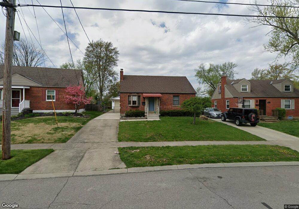
8459 Darnell Ave Cincinnati, OH 45236
Estimated Value: $258,000 - $285,657
4
Beds
2
Baths
1,184
Sq Ft
$232/Sq Ft
Est. Value
About This Home
This home is located at 8459 Darnell Ave, Cincinnati, OH 45236 and is currently estimated at $274,414, approximately $231 per square foot. 8459 Darnell Ave is a home located in Hamilton County with nearby schools including Amity Elementary School, Deer Park Jr/Sr High School, and Ohr Torah Cincinnati.
Ownership History
Date
Name
Owned For
Owner Type
Purchase Details
Closed on
Jun 27, 2018
Sold by
Mayhugh Cynthia L and Mayhugh Carroll B
Bought by
Mayhugh Carroll B and Mayhugh Cynthia L
Current Estimated Value
Purchase Details
Closed on
Jun 25, 2009
Sold by
Waldo Mark V
Bought by
Waldo Cynthia L
Purchase Details
Closed on
Apr 1, 2003
Sold by
Wagoner Charles E and Wagoner Kathleen M
Bought by
Waldo Mark and Waldo Cynthia L
Home Financials for this Owner
Home Financials are based on the most recent Mortgage that was taken out on this home.
Original Mortgage
$121,000
Interest Rate
5.94%
Mortgage Type
VA
Create a Home Valuation Report for This Property
The Home Valuation Report is an in-depth analysis detailing your home's value as well as a comparison with similar homes in the area
Home Values in the Area
Average Home Value in this Area
Purchase History
| Date | Buyer | Sale Price | Title Company |
|---|---|---|---|
| Mayhugh Carroll B | -- | None Available | |
| Waldo Cynthia L | -- | None Available | |
| Waldo Mark | $117,500 | Title Resolutions |
Source: Public Records
Mortgage History
| Date | Status | Borrower | Loan Amount |
|---|---|---|---|
| Closed | Waldo Mark | $121,000 |
Source: Public Records
Tax History
| Year | Tax Paid | Tax Assessment Tax Assessment Total Assessment is a certain percentage of the fair market value that is determined by local assessors to be the total taxable value of land and additions on the property. | Land | Improvement |
|---|---|---|---|---|
| 2025 | $4,494 | $72,209 | $11,288 | $60,921 |
| 2024 | $3,911 | $72,209 | $11,288 | $60,921 |
| 2023 | $3,980 | $72,209 | $11,288 | $60,921 |
| 2022 | $3,575 | $49,928 | $9,860 | $40,068 |
| 2021 | $3,503 | $49,928 | $9,860 | $40,068 |
| 2020 | $3,189 | $49,928 | $9,860 | $40,068 |
| 2019 | $3,116 | $43,796 | $8,649 | $35,147 |
| 2018 | $3,106 | $43,796 | $8,649 | $35,147 |
| 2017 | $2,942 | $43,796 | $8,649 | $35,147 |
| 2016 | $3,219 | $47,289 | $8,922 | $38,367 |
| 2015 | $2,984 | $47,289 | $8,922 | $38,367 |
| 2014 | $2,985 | $47,289 | $8,922 | $38,367 |
| 2013 | $3,081 | $48,255 | $9,104 | $39,151 |
Source: Public Records
Map
Nearby Homes
- 8494 Wexford Ave
- 8390 Wexford Ave
- 4104 Estermarie Dr
- 8608 Dundalk Ct
- 3647 Guam Ct
- 8468 Plainfield Rd
- 4053 Belfast Ave
- 7837 Moss Ct
- 7905 Plainfield Rd
- 8622 Plainfield Ln
- 4208 Linden Ave
- 4041 Larchview Dr
- 4120 Hoffman Ave
- 4304 Kugler Mill Rd
- 4123 Hoffman Ave
- 7719 Dearborn Ave
- 4068 Glenbar Ct
- 4305 Myrtle Ave
- 8459 Vorhees Ln
- 4152 Larchview Dr
- 8453 Darnell Ave
- 8467 Darnell Ave
- 8445 Darnell Ave
- 8473 Darnell Ave
- 8446 Wexford Ave
- 8452 Wexford Ave
- 8481 Darnell Ave
- 8439 Darnell Ave
- 8442 Wexford Ave
- 8458 Wexford Ave
- 8456 Darnell Ave
- 8470 Darnell Ave
- 8436 Wexford Ave
- 8464 Wexford Ave
- 8444 Darnell Ave
- 8487 Darnell Ave
- 3814 Mantell Ave
- 3806 Mantell Ave
- 8430 Wexford Ave
- 8484 Darnell Ave
Your Personal Tour Guide
Ask me questions while you tour the home.