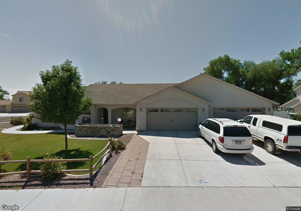
846 Sabil Dr Fruita, CO 81521
Estimated Value: $614,937 - $662,000
3
Beds
3
Baths
2,204
Sq Ft
$291/Sq Ft
Est. Value
About This Home
This home is located at 846 Sabil Dr, Fruita, CO 81521 and is currently estimated at $641,484, approximately $291 per square foot. 846 Sabil Dr is a home located in Mesa County with nearby schools including Monument Ridge Elementary School, Fruita Middle School, and Fruita 8/9 School.
Ownership History
Date
Name
Owned For
Owner Type
Purchase Details
Closed on
Apr 15, 2024
Sold by
Jones Susan Elizabeth
Bought by
Jones Jamie Rebecca
Current Estimated Value
Purchase Details
Closed on
Jun 7, 2006
Sold by
Wildwood Fruita Homes Llc
Bought by
Jones William L and Jones Susan E
Home Financials for this Owner
Home Financials are based on the most recent Mortgage that was taken out on this home.
Original Mortgage
$150,000
Interest Rate
6.56%
Mortgage Type
Fannie Mae Freddie Mac
Create a Home Valuation Report for This Property
The Home Valuation Report is an in-depth analysis detailing your home's value as well as a comparison with similar homes in the area
Home Values in the Area
Average Home Value in this Area
Purchase History
| Date | Buyer | Sale Price | Title Company |
|---|---|---|---|
| Jones Jamie Rebecca | -- | None Listed On Document | |
| Jones William L | $348,210 | Fahtco |
Source: Public Records
Mortgage History
| Date | Status | Borrower | Loan Amount |
|---|---|---|---|
| Previous Owner | Jones William L | $150,000 |
Source: Public Records
Tax History
| Year | Tax Paid | Tax Assessment Tax Assessment Total Assessment is a certain percentage of the fair market value that is determined by local assessors to be the total taxable value of land and additions on the property. | Land | Improvement |
|---|---|---|---|---|
| 2024 | $2,954 | $36,210 | $5,960 | $30,250 |
| 2023 | $2,954 | $36,210 | $5,960 | $30,250 |
| 2022 | $1,967 | $30,670 | $4,170 | $26,500 |
| 2021 | $1,981 | $31,560 | $4,290 | $27,270 |
| 2020 | $1,657 | $27,960 | $4,220 | $23,740 |
| 2019 | $1,579 | $27,960 | $4,220 | $23,740 |
| 2018 | $1,363 | $23,780 | $3,780 | $20,000 |
| 2017 | $1,878 | $23,780 | $3,780 | $20,000 |
| 2016 | $1,670 | $23,450 | $3,980 | $19,470 |
Source: Public Records
Map
Nearby Homes
- 1105 Sprocket Ct
- 921 Caledonia Ct
- 1026 Lone Tree Ct
- 1107 Mee Canyon Cir
- 1109 Mee Canyon Cir
- 1124 Sprocket Ct
- 362 Toms Canyon Dr
- 370 Toms Canyon Dr
- 1112 Sprocket Ct
- 1111 Sprocket Ct
- 858 St Peppin Dr
- 825 E Ottley Ave Unit B9
- 825 E Ottley Ave Unit B5
- 825 E Ottley Ave Unit F1
- 825 E Ottley Ave Unit E 3
- 825 E Ottley Ave Unit F4
- 791 Yew St
- 516 Vermont Ln
- 951 Vintners Ct
- 1123 Sprocket Ct
Your Personal Tour Guide
Ask me questions while you tour the home.