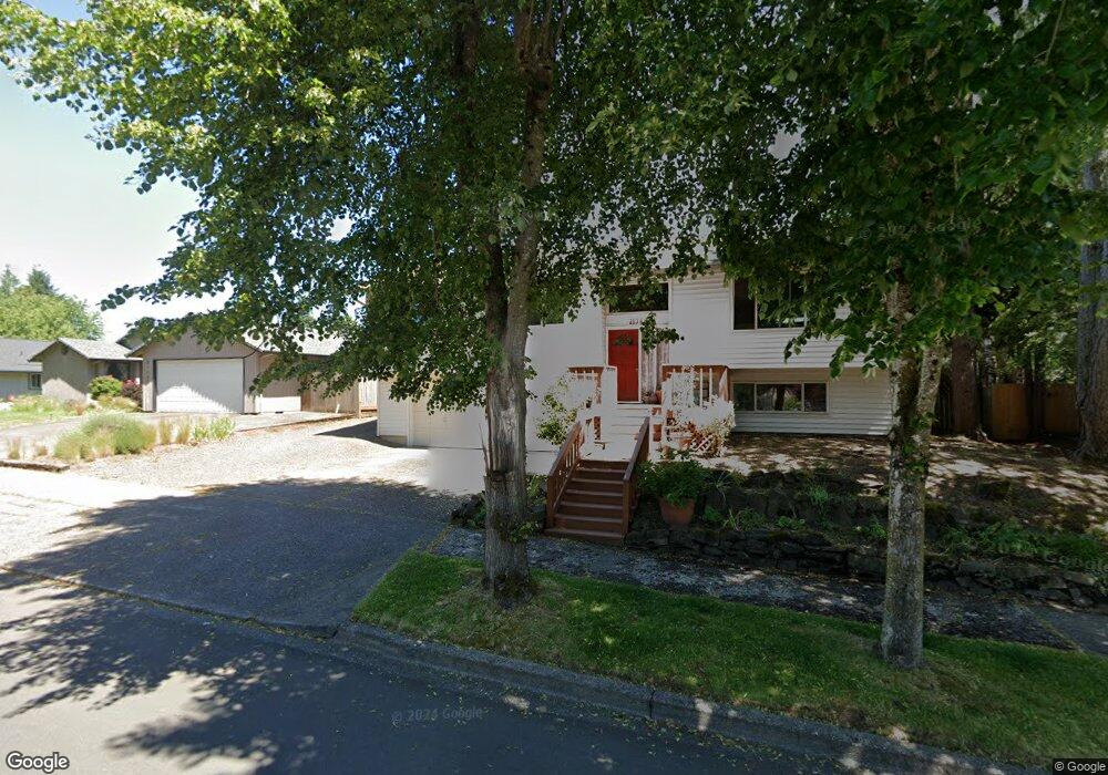
8469 SW Blake St Tualatin, OR 97062
Estimated Value: $562,000 - $624,000
4
Beds
7
Baths
1,901
Sq Ft
$317/Sq Ft
Est. Value
About This Home
This home is located at 8469 SW Blake St, Tualatin, OR 97062 and is currently estimated at $602,927, approximately $317 per square foot. 8469 SW Blake St is a home located in Washington County with nearby schools including Byrom Elementary School, Hazelbrook Middle School, and Tualatin High School.
Ownership History
Date
Name
Owned For
Owner Type
Purchase Details
Closed on
Jul 18, 2025
Sold by
Pinto Tracy Lin
Bought by
Pinto Patrice M
Current Estimated Value
Purchase Details
Closed on
Jul 16, 2001
Sold by
Mckinnon Patricia
Bought by
Pinto Patrice M and Pinto Tracy L
Home Financials for this Owner
Home Financials are based on the most recent Mortgage that was taken out on this home.
Original Mortgage
$153,000
Interest Rate
7.21%
Purchase Details
Closed on
Apr 6, 2001
Sold by
Gertz Construction Co Inc
Bought by
Mckinnon Patricia
Create a Home Valuation Report for This Property
The Home Valuation Report is an in-depth analysis detailing your home's value as well as a comparison with similar homes in the area
Home Values in the Area
Average Home Value in this Area
Purchase History
| Date | Buyer | Sale Price | Title Company |
|---|---|---|---|
| Pinto Patrice M | $310,000 | None Listed On Document | |
| Pinto Patrice M | $223,415 | Fidelity National Title Co | |
| Mckinnon Patricia | $222,950 | Fidelity National Title Co |
Source: Public Records
Mortgage History
| Date | Status | Borrower | Loan Amount |
|---|---|---|---|
| Previous Owner | Pinto Patrice M | $153,000 |
Source: Public Records
Tax History Compared to Growth
Tax History
| Year | Tax Paid | Tax Assessment Tax Assessment Total Assessment is a certain percentage of the fair market value that is determined by local assessors to be the total taxable value of land and additions on the property. | Land | Improvement |
|---|---|---|---|---|
| 2025 | $5,738 | $337,390 | -- | -- |
| 2024 | $5,588 | $327,570 | -- | -- |
| 2023 | $5,588 | $318,030 | $0 | $0 |
| 2022 | $5,347 | $318,030 | $0 | $0 |
| 2021 | $5,216 | $299,780 | $0 | $0 |
| 2020 | $5,061 | $291,050 | $0 | $0 |
| 2019 | $4,925 | $282,580 | $0 | $0 |
| 2018 | $4,726 | $274,350 | $0 | $0 |
| 2017 | $4,449 | $266,360 | $0 | $0 |
| 2016 | $4,242 | $258,610 | $0 | $0 |
| 2015 | $4,071 | $251,080 | $0 | $0 |
| 2014 | $3,955 | $243,770 | $0 | $0 |
Source: Public Records
Map
Nearby Homes
- 8263 SW Blake St
- 8501 SW Iroquois Dr
- 21932 SW Creek Dr
- 21150 SW Arapaho Ct
- 8811 SW Salinan St
- 20839 SW Martinazzi Ave
- 8821 SW Salinan St
- 8829 Salinan St
- 8836 Salinan St
- 8904 Salinan St
- 20916 SW Siletz Ct
- 22222 SW Mandan Dr
- 8715 SW Tachi Ct
- 20685 SW Siletz Ct
- 9433 SW Siuslaw Ln
- 22338 SW Pinto Dr
- 9495 SW Cherry Ln
- 20182 SW Tillamook Ct
- 9142 SW Raritan Ct
- 20168 SW Tillamook Ct
- 8467 SW Blake St
- 8465 SW Blake St
- 21366 SW Martinazzi Ave
- 21388 SW Martinazzi Ave
- 8499 SW Huron Ct
- 8488 SW Huron Ct
- 8463 SW Blake St
- 21344 SW Martinazzi Ave
- 21414 SW Martinazzi Ave
- 21381 SW Makah Ct
- 8461 SW Blake St
- 21398 SW Makah Ct
- 8476 SW Huron Ct
- 21442 SW Martinazzi Ave
- 21322 SW Martinazzi Ave
- 8487 SW Huron Ct
- 19267 SW Matinazzi Unit 1
- 8603 SW Talawa Dr
- 21370 SW Makah Ct
- 21367 SW Makah Ct