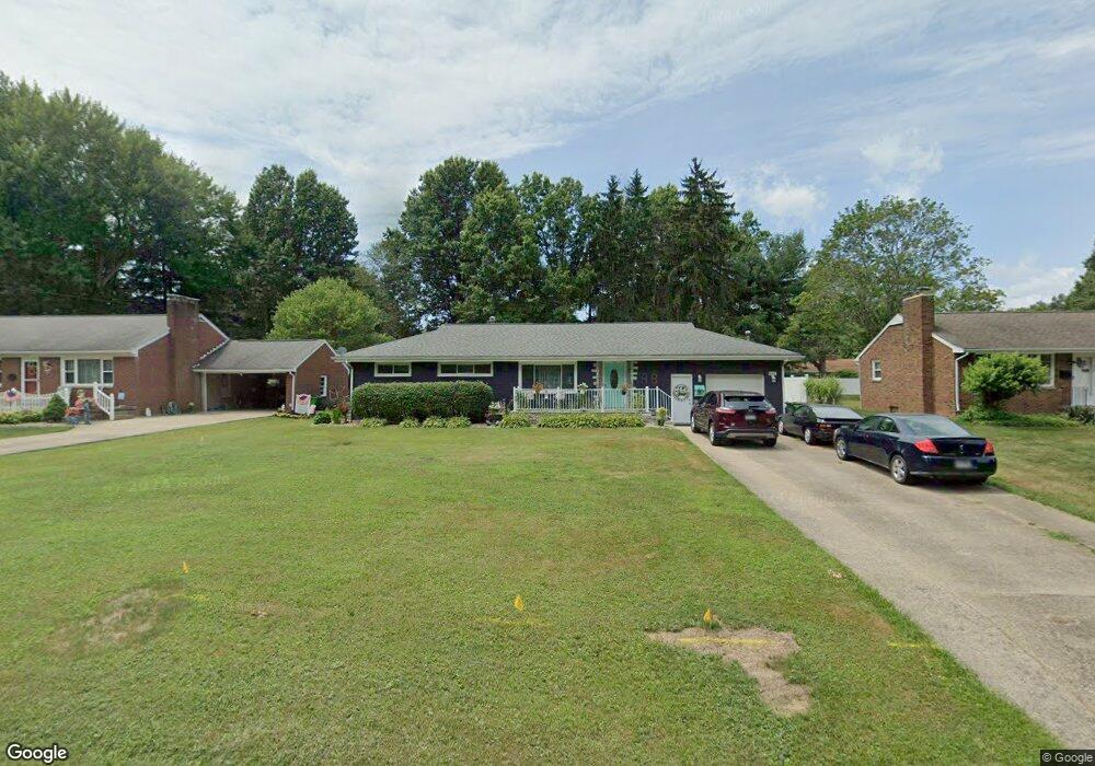
847 Bonnieview Ave Alliance, OH 44601
Estimated Value: $154,000 - $185,600
3
Beds
2
Baths
1,222
Sq Ft
$143/Sq Ft
Est. Value
About This Home
This home is located at 847 Bonnieview Ave, Alliance, OH 44601 and is currently estimated at $174,150, approximately $142 per square foot. 847 Bonnieview Ave is a home located in Stark County with nearby schools including Alliance Early Learning School, Alliance Intermediate School at Northside, and Alliance Middle School.
Ownership History
Date
Name
Owned For
Owner Type
Purchase Details
Closed on
Nov 10, 2009
Sold by
Hsbc Bank Usa Na
Bought by
Yochman Tina and Yochman Gregory
Current Estimated Value
Purchase Details
Closed on
Jun 30, 2009
Sold by
King David T
Bought by
Hsbc Bank Usa Na
Purchase Details
Closed on
Aug 11, 2008
Sold by
Estate Of Rose M King
Bought by
King David T
Create a Home Valuation Report for This Property
The Home Valuation Report is an in-depth analysis detailing your home's value as well as a comparison with similar homes in the area
Home Values in the Area
Average Home Value in this Area
Purchase History
| Date | Buyer | Sale Price | Title Company |
|---|---|---|---|
| Yochman Tina | $55,000 | Attorney | |
| Hsbc Bank Usa Na | $62,000 | None Available | |
| King David T | -- | None Available |
Source: Public Records
Tax History Compared to Growth
Tax History
| Year | Tax Paid | Tax Assessment Tax Assessment Total Assessment is a certain percentage of the fair market value that is determined by local assessors to be the total taxable value of land and additions on the property. | Land | Improvement |
|---|---|---|---|---|
| 2025 | -- | $52,090 | $14,740 | $37,350 |
| 2024 | -- | $52,090 | $14,740 | $37,350 |
| 2023 | $1,822 | $44,280 | $11,240 | $33,040 |
| 2022 | $917 | $44,280 | $11,240 | $33,040 |
| 2021 | $1,840 | $44,280 | $11,240 | $33,040 |
| 2020 | $1,675 | $37,670 | $9,770 | $27,900 |
| 2019 | $1,653 | $37,670 | $9,770 | $27,900 |
| 2018 | $1,661 | $37,670 | $9,770 | $27,900 |
| 2017 | $1,633 | $36,370 | $8,160 | $28,210 |
| 2016 | $1,388 | $30,670 | $8,160 | $22,510 |
| 2015 | $1,400 | $30,670 | $8,160 | $22,510 |
| 2014 | $1,368 | $28,530 | $7,600 | $20,930 |
| 2013 | $682 | $28,530 | $7,600 | $20,930 |
Source: Public Records
Map
Nearby Homes
- 970 Kingsway St
- 896 Parkway Blvd
- 1038 Fairview Place
- 734 Parkway Blvd
- 738 Kingsway St
- 725 W Summit St
- 1321 Parkway Blvd
- 645 W Summit St
- 1201 Overlook Dr
- 565 W Broadway St
- 1515 S Rockhill Ave
- 140 W Summit St
- 345 W Market St
- 884 W College Rd
- 132 S Haines Ave
- 807 S Union Ave
- 329 1/2 W Main St
- 163 W Market St
- 427 S Union Ave
- 511 W Ely St
- 861 Bonnieview Ave
- 835 Bonnieview Ave
- 819 Bonnieview Ave
- 840 Fairview Place
- 1019 Glamorgan St
- 858 Fairview Place
- 820 Fairview Place
- 811 Bonnieview Ave
- 824 Bonnieview Ave
- 1039 Glamorgan St
- 993 Glamorgan St
- 800 Fairview Place
- 1057 Glamorgan St
- 765 Bonnieview Ave
- 975 Glamorgan St
- 756 Fairview Place
- 965 Glamorgan St
- 1075 Glamorgan St
- 745 Bonnieview Ave
- 758 Bonnieview Ave