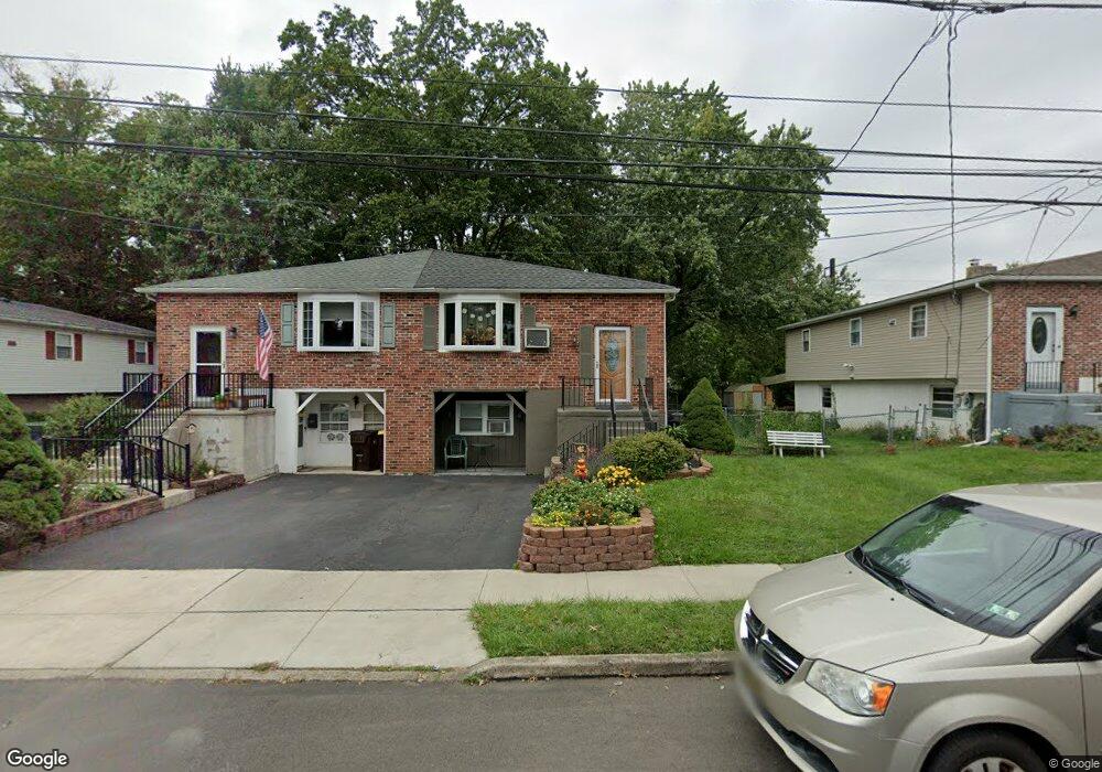
848 Cherry St Lansdale, PA 19446
Estimated Value: $264,000 - $368,470
4
Beds
2
Baths
1,250
Sq Ft
$258/Sq Ft
Est. Value
About This Home
This home is located at 848 Cherry St, Lansdale, PA 19446 and is currently estimated at $323,118, approximately $258 per square foot. 848 Cherry St is a home located in Montgomery County with nearby schools including Gwyn-Nor El School, Pennbrook Middle School, and North Penn Senior High School.
Ownership History
Date
Name
Owned For
Owner Type
Purchase Details
Closed on
May 8, 2018
Sold by
Baston Gail R and Hill Amy J
Bought by
Hill Amy J and Hill Christopher D
Current Estimated Value
Purchase Details
Closed on
Mar 14, 2002
Sold by
Va
Bought by
Batson John S and Batson Gail R
Purchase Details
Closed on
Aug 10, 2001
Sold by
Carty Robert and Carty Maria
Bought by
Va
Purchase Details
Closed on
Nov 16, 1995
Sold by
Kelly Kevin M and Kelly Gail M
Bought by
Carty Robert and Carty Maria
Create a Home Valuation Report for This Property
The Home Valuation Report is an in-depth analysis detailing your home's value as well as a comparison with similar homes in the area
Home Values in the Area
Average Home Value in this Area
Purchase History
| Date | Buyer | Sale Price | Title Company |
|---|---|---|---|
| Hill Amy J | -- | None Available | |
| Batson John S | $100,000 | -- | |
| Va | $1,847 | -- | |
| Carty Robert | $110,000 | -- |
Source: Public Records
Tax History Compared to Growth
Tax History
| Year | Tax Paid | Tax Assessment Tax Assessment Total Assessment is a certain percentage of the fair market value that is determined by local assessors to be the total taxable value of land and additions on the property. | Land | Improvement |
|---|---|---|---|---|
| 2025 | $4,405 | $104,740 | -- | -- |
| 2024 | $4,405 | $104,740 | -- | -- |
| 2023 | $4,122 | $104,740 | $0 | $0 |
| 2022 | $3,991 | $104,740 | $0 | $0 |
| 2021 | $3,828 | $104,740 | $0 | $0 |
| 2020 | $3,712 | $104,740 | $0 | $0 |
| 2019 | $3,651 | $104,740 | $0 | $0 |
| 2018 | $979 | $104,740 | $0 | $0 |
| 2017 | $3,408 | $104,740 | $0 | $0 |
| 2016 | $3,367 | $104,740 | $0 | $0 |
| 2015 | $3,125 | $104,740 | $0 | $0 |
| 2014 | $3,125 | $104,740 | $0 | $0 |
Source: Public Records
Map
Nearby Homes
- 710 Willow St Unit B
- 713 Willow St Unit A-2
- 472 Wade Ave
- 30 Kearney Dr
- 4 Kearney Dr
- 202 Arbour Ct Unit CONDO 202
- 19 Wexford Dr
- 1402 Hearth Dr
- 220 Pennbrook Ave
- 160 Church Rd
- 197 Eric Ln
- 380 E Hancock St Unit 100A
- 380 E Hancock St Unit 104A
- 380 E Hancock St Unit 103A
- 380 E Hancock St Unit 101A
- 380 E Hancock St Unit 103B
- 380 E Hancock St Unit 102B
- 380 E Hancock St Unit 101B
- 380 E Hancock St Unit 100B
- 380 E Hancock St Unit 102A
- 844 Cherry St
- 850 Cherry St
- 842 Cherry St
- 854 Cherry St
- 838 Cherry St
- 856 Cherry St
- 818 Pennbrook Ave
- 836 Cherry St
- 816 Pennbrook Ave
- 832 Cherry St
- 812 Pennbrook Ave
- 827 Pennbrook Ave
- 830 Cherry St
- 825 Pennbrook Ave
- 821 Pennbrook Ave
- 819 Pennbrook Ave
- 810 Pennbrook Ave
- 826 Cherry St
- 850 Clay Ave
- 815 Pennbrook Ave