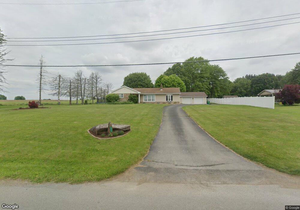
848 Whitestown Rd Butler, PA 16001
Connoquenessing Township NeighborhoodEstimated Value: $167,000 - $402,000
3
Beds
1
Bath
1,292
Sq Ft
$253/Sq Ft
Est. Value
About This Home
This home is located at 848 Whitestown Rd, Butler, PA 16001 and is currently estimated at $327,141, approximately $253 per square foot. 848 Whitestown Rd is a home located in Butler County with nearby schools including Butler Intermediate High School and Butler Middle School.
Ownership History
Date
Name
Owned For
Owner Type
Purchase Details
Closed on
Aug 13, 2019
Sold by
Rodgers Richard J and Rodgers Ruth K
Bought by
Osborne Brittany N and Osborne Isaac J
Current Estimated Value
Home Financials for this Owner
Home Financials are based on the most recent Mortgage that was taken out on this home.
Original Mortgage
$239,000
Outstanding Balance
$209,320
Interest Rate
3.7%
Mortgage Type
New Conventional
Estimated Equity
$117,821
Purchase Details
Closed on
Sep 29, 2010
Sold by
Clark James H
Bought by
Rodgers Richard J
Create a Home Valuation Report for This Property
The Home Valuation Report is an in-depth analysis detailing your home's value as well as a comparison with similar homes in the area
Home Values in the Area
Average Home Value in this Area
Purchase History
| Date | Buyer | Sale Price | Title Company |
|---|---|---|---|
| Osborne Brittany N | $246,392 | Attorney | |
| Rodgers Richard J | $217,000 | -- |
Source: Public Records
Mortgage History
| Date | Status | Borrower | Loan Amount |
|---|---|---|---|
| Open | Osborne Brittany N | $239,000 |
Source: Public Records
Tax History Compared to Growth
Tax History
| Year | Tax Paid | Tax Assessment Tax Assessment Total Assessment is a certain percentage of the fair market value that is determined by local assessors to be the total taxable value of land and additions on the property. | Land | Improvement |
|---|---|---|---|---|
| 2025 | $2,223 | $15,550 | $810 | $14,740 |
| 2024 | $2,174 | $15,550 | $810 | $14,740 |
| 2023 | $2,128 | $15,550 | $810 | $14,740 |
| 2022 | $2,120 | $15,550 | $810 | $14,740 |
| 2021 | $2,097 | $15,550 | $0 | $0 |
| 2020 | $2,097 | $15,550 | $810 | $14,740 |
| 2019 | $2,050 | $15,550 | $810 | $14,740 |
| 2018 | $2,035 | $15,550 | $810 | $14,740 |
| 2017 | $1,985 | $15,550 | $810 | $14,740 |
| 2016 | $538 | $15,550 | $810 | $14,740 |
| 2015 | $315 | $15,550 | $810 | $14,740 |
| 2014 | $315 | $15,550 | $810 | $14,740 |
Source: Public Records
Map
Nearby Homes
- 3012 Brandywine Blvd
- 2043 Winchester Ct
- 2113 Winchester Ct
- 101 Napa Ct
- 105 Lawrence Ave
- 701 Daisy Lane Extension
- 106 Orchard Dr
- 594 Whitestown Rd
- 219 Meridian Rd
- 119 Easy St
- 221 Deer Run Dr
- Lot 10 Winterwood Dr
- 100 Marion Dr
- 553 Dick Rd
- 1303 Cherry Tree Dr
- 1304 Cherry Tree Dr
- 1302 Cherry Tree Dr
- 1301 Cherry Tree Dr
- 1404 Cherry Tree Dr
- 1401 Cherry Tree Dr
- 846 Whitestown Rd
- 844 Whitestown Rd
- 847 Whitestown Rd
- 839 Whitestown Rd
- 855 Whitestown Rd
- 837 Whitestown Rd
- 836 Whitestown Rd
- 842 Whitestown Rd
- 859 Whitestown Rd
- 861 Whitestown Rd
- 863 Whitestown Rd
- 828 Whitestown Rd
- 1161 Silver Oak Dr
- 882 Whitestown Rd
- 1184 Silver Oak Dr
- 824 Whitestown Rd
- 914 Whitestown Rd
- 119 Holt Ln
- 118 Holt Ln
- 1062 Silver Oak Dr