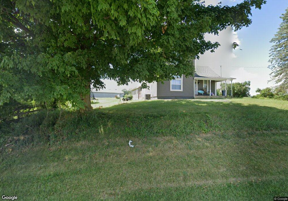
8488 S State Route 53 Mc Cutchenville, OH 44844
Estimated Value: $137,000 - $193,537
3
Beds
1
Bath
1,466
Sq Ft
$107/Sq Ft
Est. Value
About This Home
This home is located at 8488 S State Route 53, Mc Cutchenville, OH 44844 and is currently estimated at $156,634, approximately $106 per square foot. 8488 S State Route 53 is a home with nearby schools including Mohawk Elementary School and Mohawk High School.
Ownership History
Date
Name
Owned For
Owner Type
Purchase Details
Closed on
Jan 9, 2020
Sold by
Ward Kaleb D
Bought by
Ward Jamie M
Current Estimated Value
Home Financials for this Owner
Home Financials are based on the most recent Mortgage that was taken out on this home.
Original Mortgage
$65,500
Outstanding Balance
$57,983
Interest Rate
3.7%
Mortgage Type
Closed End Mortgage
Estimated Equity
$98,651
Purchase Details
Closed on
Aug 23, 2016
Sold by
Sprau Virgil W and Virgil W Sprau Living Trust
Bought by
Ward Kaleb D and Ward Jamie M
Purchase Details
Closed on
May 4, 2016
Sold by
Sprau Virgil W and Virgil W Sprau Living Trust
Bought by
Sprau Virgil W
Purchase Details
Closed on
Jan 4, 2012
Sold by
Sprau Virgil W
Bought by
Sprau Virgil W and Virgil W Sprau Living Trust
Purchase Details
Closed on
Feb 2, 1996
Sold by
Sprau Virgil W and Sprau Ruth E
Bought by
Sprau Virgil W
Create a Home Valuation Report for This Property
The Home Valuation Report is an in-depth analysis detailing your home's value as well as a comparison with similar homes in the area
Home Values in the Area
Average Home Value in this Area
Purchase History
| Date | Buyer | Sale Price | Title Company |
|---|---|---|---|
| Ward Jamie M | -- | Beck Title Agency Ltd | |
| Ward Kaleb D | $40,000 | Assured Title | |
| Sprau Virgil W | -- | None Available | |
| Sprau Virgil W | -- | None Available | |
| Sprau Virgil W | -- | -- |
Source: Public Records
Mortgage History
| Date | Status | Borrower | Loan Amount |
|---|---|---|---|
| Open | Ward Jamie M | $65,500 |
Source: Public Records
Tax History Compared to Growth
Tax History
| Year | Tax Paid | Tax Assessment Tax Assessment Total Assessment is a certain percentage of the fair market value that is determined by local assessors to be the total taxable value of land and additions on the property. | Land | Improvement |
|---|---|---|---|---|
| 2024 | $1,503 | $46,630 | $12,510 | $34,120 |
| 2023 | $1,504 | $46,630 | $12,510 | $34,120 |
| 2022 | $1,215 | $33,440 | $11,070 | $22,370 |
| 2021 | $1,199 | $33,440 | $11,070 | $22,370 |
| 2020 | $1,232 | $33,440 | $11,071 | $22,369 |
| 2019 | $1,040 | $28,578 | $9,625 | $18,953 |
| 2018 | $1,050 | $28,578 | $9,625 | $18,953 |
| 2017 | $1,692 | $28,578 | $9,625 | $18,953 |
| 2016 | $989 | $28,655 | $7,875 | $20,780 |
| 2015 | $2,304 | $87,697 | $66,917 | $20,780 |
| 2014 | $2,027 | $87,697 | $66,917 | $20,780 |
| 2013 | $1,171 | $72,255 | $51,475 | $20,780 |
Source: Public Records
Map
Nearby Homes
- 8239 S State Route 53
- 8239 Ohio 53
- 6590 State Route 587
- 10778 County Highway 5
- 9940 Township Highway 18
- 150 E Township Road 42
- 255 W County Road 6
- 0 Benton St
- 106 N Sycamore Ave
- 104 E Saffell Ave
- 305 W 10th St
- 2031 W County Road 52
- 166 E County Road 16
- 2050 W County Road 52
- 2483 W County Road 52
- 4277 County Highway 134
- 2351 S State Route 53
- 00 S Township Road 66
- 0 S Township Road 66
- 2465 S County Road 19
- 8275 S State Route 53
- 8351 N State Route 53
- 8760 S State Route 53
- 8771 S State Route 53
- 4360 Township Road 1069
- 8780 S State Route 53
- 8801 Ohio 53
- 8794 Ohio 53
- 8794 N State Route 53
- 8801 S State Route 53
- 8815 S State Route 53
- 8820 S State Route 53
- 8855 High St
- 4238 W Township Road 26
- 8845 S State Route 53
- 8845 Ohio 53
- 4404 W Tr 1070
- 4400 Township Road 1070
- 8773 County Road 47 County Rd
- 8855 S State Route 53