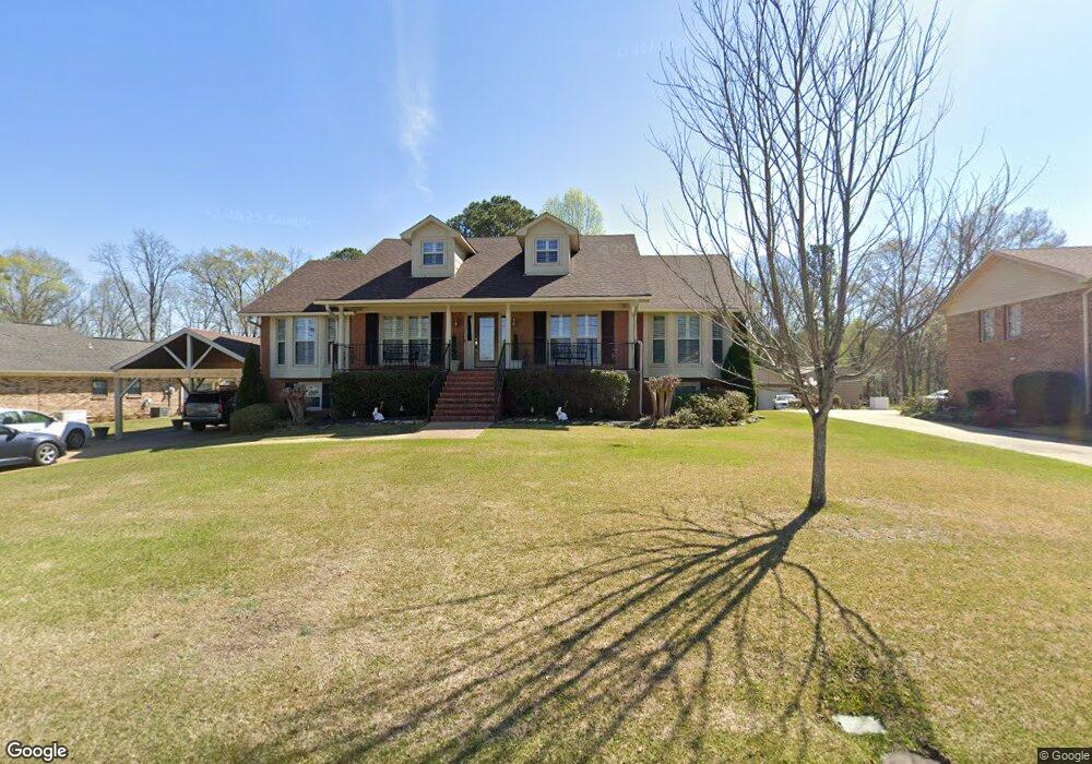
849 Peterson Dr Gardendale, AL 35071
Estimated Value: $329,243 - $360,000
3
Beds
2
Baths
3,135
Sq Ft
$111/Sq Ft
Est. Value
About This Home
This home is located at 849 Peterson Dr, Gardendale, AL 35071 and is currently estimated at $348,811, approximately $111 per square foot. 849 Peterson Dr is a home located in Jefferson County with nearby schools including Gardendale Elementary School, Bragg Middle School, and Gardendale High School.
Ownership History
Date
Name
Owned For
Owner Type
Purchase Details
Closed on
Mar 10, 2025
Sold by
Davis Tony R
Bought by
Davis Tony R and Davis Luanne Dabbs
Current Estimated Value
Purchase Details
Closed on
May 30, 2003
Sold by
Dabbs Gary and Dabbs Keith
Bought by
Dabbs Emilou
Purchase Details
Closed on
Nov 12, 1999
Sold by
Neal Reed Benny and Neal Day D
Bought by
Dabbs Davis Tony R and Dabbs Davis Barnette Luanne
Home Financials for this Owner
Home Financials are based on the most recent Mortgage that was taken out on this home.
Original Mortgage
$179,550
Interest Rate
7.7%
Create a Home Valuation Report for This Property
The Home Valuation Report is an in-depth analysis detailing your home's value as well as a comparison with similar homes in the area
Home Values in the Area
Average Home Value in this Area
Purchase History
| Date | Buyer | Sale Price | Title Company |
|---|---|---|---|
| Davis Tony R | -- | -- | |
| Dabbs Emilou | -- | -- | |
| Dabbs Davis Tony R | $189,000 | -- |
Source: Public Records
Mortgage History
| Date | Status | Borrower | Loan Amount |
|---|---|---|---|
| Previous Owner | Dabbs Davis Tony R | $179,550 |
Source: Public Records
Tax History Compared to Growth
Tax History
| Year | Tax Paid | Tax Assessment Tax Assessment Total Assessment is a certain percentage of the fair market value that is determined by local assessors to be the total taxable value of land and additions on the property. | Land | Improvement |
|---|---|---|---|---|
| 2024 | $1,389 | $29,980 | -- | -- |
| 2022 | $1,672 | $35,250 | $3,400 | $31,850 |
| 2021 | $1,150 | $21,960 | $3,400 | $18,560 |
| 2020 | $1,463 | $25,220 | $3,400 | $21,820 |
| 2019 | $1,204 | $20,920 | $0 | $0 |
| 2018 | $1,379 | $23,820 | $0 | $0 |
| 2017 | $1,308 | $22,640 | $0 | $0 |
| 2016 | $1,308 | $22,640 | $0 | $0 |
| 2015 | $1,308 | $22,640 | $0 | $0 |
| 2014 | $1,143 | $22,280 | $0 | $0 |
| 2013 | $1,143 | $22,280 | $0 | $0 |
Source: Public Records
Map
Nearby Homes
- 200 Watson Way
- 900 Absher St
- 848 Horne Ln
- 817 Downs Ave
- 716 Downs Ave
- 1031 Mount Olive Ave Unit 17/18
- 408 Albert Dr
- 300 Minor Rd
- 411 Albert Dr
- 225 Payne Rd
- 220 Payne Rd
- 1308 Colonial Ave
- 304 Fieldstown Rd
- 0 Odum Rd
- 164 Summit Blvd
- 267 Garrison Rd
- 235 Garrison Rd
- 528 Park St
- 224 Iris Dr
- 411 Jamestown Manor Dr
- 845 Peterson Dr
- 853 Peterson Dr
- 857 Peterson Dr
- 844 Peterson Dr
- 300 Crista Cir
- 200 Westchester Cir
- 216 Crista Cir
- 861 Peterson Dr
- 205 Westchester Cir
- 204 Westchester Cir
- 212 Crista Cir
- 856 Peterson Dr
- 841 Peterson Dr
- 315 Crista Cir
- 305 Crista Cir
- 217 Crista Cir
- 208 Crista Cir
- 209 Westchester Cir
- 309 Crista Cir
- 317 Crista Cir