H
Seller's Agent in 2026
Hvizda Realty Group
EXP Realty
(603) 733-4811
6 in this area
495 Total Sales
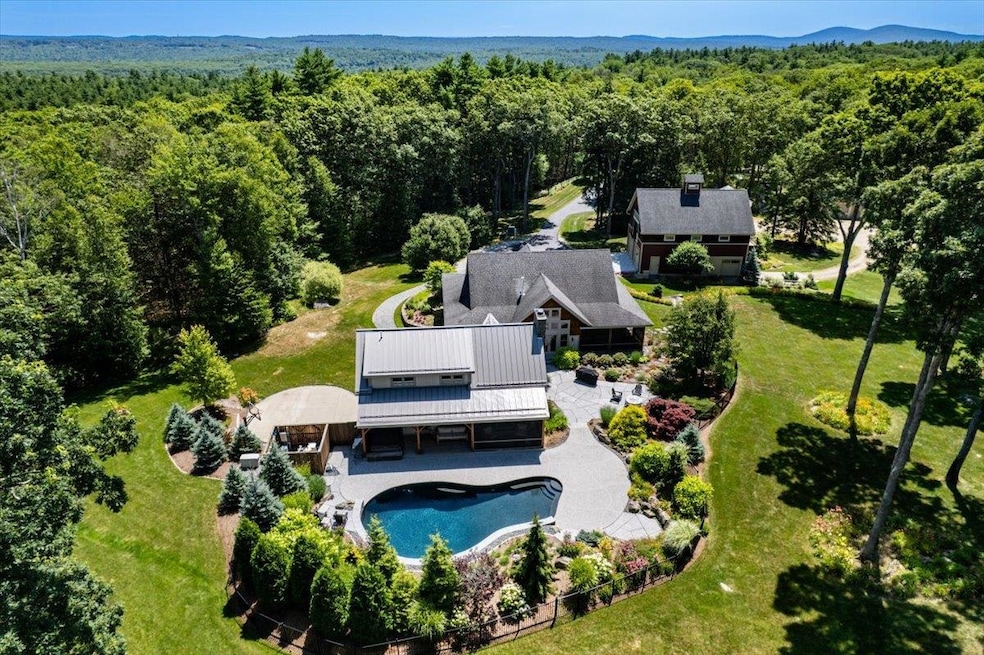


Every inch of this extraordinary home has been meticulously reimagined, torn down to the studs and completely rebuilt within the last two years, blending timeless craftsmanship with luxurious modern amenities. From the moment you step inside, the soaring ceilings, California hardwood floors, and custom finishes set an unforgettable tone. The main house features a chef’s kitchen designed for both entertaining and everyday living, a 1st floor primary suite, and a stunning guest wing anchored by a floor-to-ceiling stone fireplace. The flow from indoors to outdoors is seamless, leading to a resort worthy inground pool framed by lush gardens that create your own private oasis. The finished lower level offers a spacious entertainment room and a fully equipped home gym. A detached 3 story garage provides endless possibilities, with multiple levels for parking, storage, and hobbies. The top floor boasts a sun filled open concept in-law apartment with private laundry, accessible via a traditional staircase or a striking spiral staircase. An additional 5 bay garage ensures there’s room for every vehicle, tool, and toy. Set on over 13 acres of meticulously maintained grounds, this property is perfectly located near Pat’s Peak and Mount Sunapee, ideal for ski enthusiasts and surrounded by ample ATV and snowmobile trails for year round outdoor adventure. This is more than a home, it’s a lifestyle.
Last Agent to Sell the Property
EXP Realty Brokerage Phone: 603-557-6661 License #069330 Listed on: 10/31/2025

We collect this data history from publicly available records. To have your information removed, we recommend requesting removal directly through your county’s website.
| Date | Type | Sale Price | Title Company |
|---|---|---|---|
| Quit Claim Deed | -- | -- |
| Date | Event | Price | List to Sale | Price per Sq Ft |
|---|---|---|---|---|
| 04/02/2026 04/02/26 | Sold | $1,921,650 | -8.5% | $333 / Sq Ft |
| 11/28/2025 11/28/25 | Price Changed | $2,100,000 | -6.7% | $364 / Sq Ft |
| 10/31/2025 10/31/25 | For Sale | $2,250,000 | -- | $390 / Sq Ft |
| Year | Tax Paid | Tax Assessment Tax Assessment Total Assessment is a certain percentage of the fair market value that is determined by local assessors to be the total taxable value of land and additions on the property. | Land | Improvement |
|---|---|---|---|---|
| 2025 | $16,465 | $760,860 | $98,360 | $662,500 |
| 2024 | $15,514 | $760,862 | $98,362 | $662,500 |
| 2023 | $14,338 | $761,026 | $98,526 | $662,500 |
| 2022 | $13,242 | $761,013 | $98,513 | $662,500 |
| 2021 | $13,089 | $761,007 | $98,507 | $662,500 |
| 2020 | $13,804 | $576,373 | $79,773 | $496,600 |
| 2019 | $11,968 | $504,773 | $79,773 | $425,000 |
| 2018 | $9,439 | $409,871 | $79,771 | $330,100 |
| 2016 | $7,186 | $321,234 | $76,134 | $245,100 |
| 2015 | $7,059 | $314,998 | $72,398 | $242,600 |
| 2014 | $6,996 | $314,986 | $72,386 | $242,600 |
| 2013 | $6,850 | $314,927 | $93,300 | $221,627 |
H
Seller's Agent in 2026
Hvizda Realty Group
EXP Realty
(603) 733-4811
6 in this area
495 Total Sales
Buyer's Agent in 2026
Joe Leddy
Duston Leddy Real Estate
(603) 494-6864
1 in this area
185 Total Sales
Source: PrimeMLS
MLS Number: 5068103
APN: WEAR-000409-000000-000059-000004
Disclaimer: Certain information contained herein is derived from information provided by parties other than Homes.com. All information provided is deemed reliable, but is not guaranteed to be accurate and should be independently verified.
![]() Copyright 2026 PrimeMLS, Inc. All rights reserved. This information is deemed reliable, but not guaranteed. The data relating to real estate displayed on this display comes in part from the IDX Program of PrimeMLS. The information being provided is for consumers’ personal, non-commercial use and may not be used for any purpose other than to identify prospective properties consumers may be interested in purchasing.
Copyright 2026 PrimeMLS, Inc. All rights reserved. This information is deemed reliable, but not guaranteed. The data relating to real estate displayed on this display comes in part from the IDX Program of PrimeMLS. The information being provided is for consumers’ personal, non-commercial use and may not be used for any purpose other than to identify prospective properties consumers may be interested in purchasing.
Ask me questions while you tour the home.