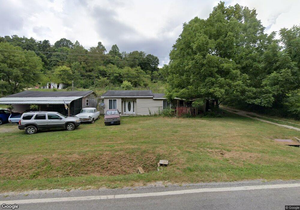
8493 State Route 243 South Point, OH 45680
Estimated Value: $80,000 - $166,000
3
Beds
2
Baths
1,932
Sq Ft
$63/Sq Ft
Est. Value
About This Home
This home is located at 8493 State Route 243, South Point, OH 45680 and is currently estimated at $122,437, approximately $63 per square foot. 8493 State Route 243 is a home with nearby schools including Dawson-Bryant Elementary School, Dawson-Bryant Middle School, and Dawson-Bryant High School.
Ownership History
Date
Name
Owned For
Owner Type
Purchase Details
Closed on
Jul 13, 2022
Sold by
Jordan Sr William D
Bought by
Jordan William D
Current Estimated Value
Purchase Details
Closed on
Oct 6, 2016
Sold by
Jordan William D
Bought by
Jordan William D and Jordan Delbert
Purchase Details
Closed on
Sep 20, 2016
Sold by
Adkins Debra and Jordan Debra
Bought by
Jordan William D
Purchase Details
Closed on
Jan 1, 1987
Bought by
Jordan Delbert and Jordan Debra
Create a Home Valuation Report for This Property
The Home Valuation Report is an in-depth analysis detailing your home's value as well as a comparison with similar homes in the area
Home Values in the Area
Average Home Value in this Area
Purchase History
| Date | Buyer | Sale Price | Title Company |
|---|---|---|---|
| Jordan William D | -- | None Listed On Document | |
| Jordan William D | -- | Attorney | |
| Jordan William D | -- | Attorney | |
| Jordan William D | -- | Attorney | |
| Jordan Delbert | -- | -- |
Source: Public Records
Tax History Compared to Growth
Tax History
| Year | Tax Paid | Tax Assessment Tax Assessment Total Assessment is a certain percentage of the fair market value that is determined by local assessors to be the total taxable value of land and additions on the property. | Land | Improvement |
|---|---|---|---|---|
| 2024 | -- | $21,930 | $3,150 | $18,780 |
| 2023 | $379 | $21,930 | $3,150 | $18,780 |
| 2022 | $390 | $21,930 | $3,150 | $18,780 |
| 2021 | $350 | $20,780 | $2,990 | $17,790 |
| 2020 | $366 | $20,780 | $2,990 | $17,790 |
| 2019 | $947 | $32,540 | $2,990 | $29,550 |
| 2018 | $866 | $29,330 | $2,930 | $26,400 |
| 2017 | $864 | $29,330 | $2,930 | $26,400 |
| 2016 | $819 | $29,330 | $2,930 | $26,400 |
| 2015 | $682 | $23,400 | $2,430 | $20,970 |
| 2014 | $673 | $23,400 | $2,430 | $20,970 |
| 2013 | $672 | $23,400 | $2,430 | $20,970 |
Source: Public Records
Map
Nearby Homes
- 9040 Ohio 243
- 6881 State Route 243
- 1122 Township Road 266
- 1122 Township Road 266
- 66 County Road 30
- 3493 County Road 31
- 3569 County Road 6
- 4404 County Road 15
- 66 Township Road 1523
- 25 Township Road 1524
- 3171 County Road 31
- 859 County Road 53
- 885 County Road 53
- 6757 County Road 15
- 6897 County Road 15
- 1225 County Road 15
- 48 Private Drive 1179
- 572 Township Road 145
- 572 Township Road 145 Unit KO-4
- 119 County Road 15
- 8427 State Route 243
- 8416 State Route 243
- 8559 State Route 243
- 8394 State Route 243
- 8208 Ohio 243
- 8256 State Route 243
- 8321 State Route 243
- 8754 State Route 243
- 8208 State Route 243
- 1064 Township Road 250
- 8191 State Route 243
- 8902 State Route 243
- 0000 State Route 243 Unit Co Rd 17
- 253 Ohio 243 Unit 1357
- 8114 State Route 243
- 908 Township Road 250
- 8098 State Route 243
- 8881 State Route 243
- 1234 Township Road 250
- 771 Township Road 250