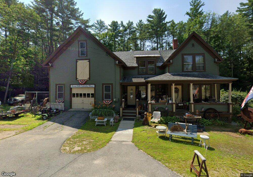
85 Federal Rd Parsonsfield, ME 04047
Estimated Value: $253,995 - $363,000
2
Beds
1
Bath
692
Sq Ft
$470/Sq Ft
Est. Value
About This Home
This home is located at 85 Federal Rd, Parsonsfield, ME 04047 and is currently estimated at $324,999, approximately $469 per square foot. 85 Federal Rd is a home.
Ownership History
Date
Name
Owned For
Owner Type
Purchase Details
Closed on
Jul 8, 2014
Sold by
Brown Audrey A
Bought by
Brown Audrey A and Brown Douglas M
Current Estimated Value
Home Financials for this Owner
Home Financials are based on the most recent Mortgage that was taken out on this home.
Original Mortgage
$119,420
Outstanding Balance
$90,962
Interest Rate
4.16%
Mortgage Type
Commercial
Estimated Equity
$234,037
Purchase Details
Closed on
Jan 5, 2007
Sold by
Hillery Cheryl J and Hillery Richard E
Bought by
Erlandson Mark R and Hatch David H
Home Financials for this Owner
Home Financials are based on the most recent Mortgage that was taken out on this home.
Original Mortgage
$125,600
Interest Rate
6.24%
Mortgage Type
Commercial
Purchase Details
Closed on
Nov 28, 2005
Sold by
Casazza Anthony J
Bought by
Hillery Cheryl J and Hillery Richard E
Home Financials for this Owner
Home Financials are based on the most recent Mortgage that was taken out on this home.
Original Mortgage
$120,000
Interest Rate
6.06%
Mortgage Type
Commercial
Create a Home Valuation Report for This Property
The Home Valuation Report is an in-depth analysis detailing your home's value as well as a comparison with similar homes in the area
Home Values in the Area
Average Home Value in this Area
Purchase History
| Date | Buyer | Sale Price | Title Company |
|---|---|---|---|
| Brown Audrey A | -- | -- | |
| Erlandson Mark R | -- | -- | |
| Hillery Cheryl J | -- | -- |
Source: Public Records
Mortgage History
| Date | Status | Borrower | Loan Amount |
|---|---|---|---|
| Open | Brown Audrey A | $119,420 | |
| Closed | Erlandson Mark R | $125,600 | |
| Previous Owner | Hillery Cheryl J | $120,000 |
Source: Public Records
Tax History Compared to Growth
Tax History
| Year | Tax Paid | Tax Assessment Tax Assessment Total Assessment is a certain percentage of the fair market value that is determined by local assessors to be the total taxable value of land and additions on the property. | Land | Improvement |
|---|---|---|---|---|
| 2024 | $2,077 | $123,623 | $44,950 | $78,673 |
| 2023 | $2,003 | $123,623 | $44,950 | $78,673 |
| 2022 | $1,916 | $123,623 | $44,950 | $78,673 |
| 2021 | $1,910 | $123,623 | $44,950 | $78,673 |
| 2020 | $555 | $123,623 | $44,950 | $78,673 |
| 2019 | $1,842 | $123,623 | $44,950 | $78,673 |
| 2017 | $1,960 | $123,623 | $44,950 | $78,673 |
| 2016 | $1,863 | $123,623 | $44,950 | $78,673 |
| 2015 | $1,811 | $120,702 | $44,950 | $75,752 |
| 2013 | $1,762 | $120,702 | $44,950 | $75,752 |
Source: Public Records
Map
Nearby Homes
- 12 Main St
- 32 Summer St
- 35 Pine St
- 122 Ossipee Trail
- 266 S Hiram Rd
- 248 Spec Pond Rd
- 206 Gilman Rd
- 272 Tripptown Rd
- R3-32 Ossipee Trail
- 696 S Hiram Rd
- 761 Pendexter Rd
- 42AC Ben Gilpatrick Rd
- 00 Brownfield Rd
- 96 Maple St
- 62 Eastman Hill Rd
- Lot #8 Jordan Heights Rd
- Lot #2 Jordan Heights Rd
- Lot #3 Jordan Heights Rd
- 839 Brownfield Rd
- 20 Main St