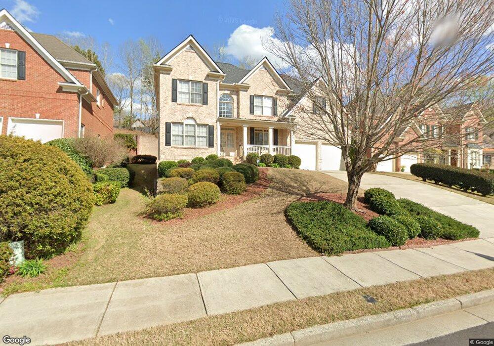
850 Cooper Farm Way Duluth, GA 30097
Estimated Value: $814,225 - $910,000
5
Beds
4
Baths
3,256
Sq Ft
$264/Sq Ft
Est. Value
About This Home
This home is located at 850 Cooper Farm Way, Duluth, GA 30097 and is currently estimated at $860,056, approximately $264 per square foot. 850 Cooper Farm Way is a home located in Fulton County with nearby schools including Wilson Creek Elementary School, River Trail Middle School, and Northview High School.
Ownership History
Date
Name
Owned For
Owner Type
Purchase Details
Closed on
Apr 9, 2003
Sold by
Yeh Stephen H
Bought by
Yeh Stephen H and Yeh Jean
Current Estimated Value
Home Financials for this Owner
Home Financials are based on the most recent Mortgage that was taken out on this home.
Original Mortgage
$150,000
Interest Rate
5.74%
Mortgage Type
New Conventional
Create a Home Valuation Report for This Property
The Home Valuation Report is an in-depth analysis detailing your home's value as well as a comparison with similar homes in the area
Home Values in the Area
Average Home Value in this Area
Purchase History
| Date | Buyer | Sale Price | Title Company |
|---|---|---|---|
| Yeh Stephen H | -- | -- | |
| Yeh Stephen H | $370,000 | -- |
Source: Public Records
Mortgage History
| Date | Status | Borrower | Loan Amount |
|---|---|---|---|
| Previous Owner | Yeh Stephen H | $150,000 |
Source: Public Records
Tax History Compared to Growth
Tax History
| Year | Tax Paid | Tax Assessment Tax Assessment Total Assessment is a certain percentage of the fair market value that is determined by local assessors to be the total taxable value of land and additions on the property. | Land | Improvement |
|---|---|---|---|---|
| 2025 | $2,390 | $298,920 | $78,680 | $220,240 |
| 2023 | $7,563 | $267,960 | $49,160 | $218,800 |
| 2022 | $2,424 | $267,960 | $49,160 | $218,800 |
| 2021 | $2,144 | $172,080 | $35,920 | $136,160 |
| 2020 | $2,136 | $170,080 | $35,520 | $134,560 |
| 2019 | $71 | $181,720 | $41,280 | $140,440 |
| 2018 | $5,380 | $177,440 | $40,280 | $137,160 |
| 2017 | $5,394 | $170,640 | $38,760 | $131,880 |
| 2016 | $5,308 | $170,640 | $38,760 | $131,880 |
| 2015 | $5,366 | $170,640 | $38,760 | $131,880 |
| 2014 | $5,558 | $170,640 | $38,760 | $131,880 |
Source: Public Records
Map
Nearby Homes
- 5765 Bailey Ridge Ct
- 10950 Glenhurst Pass
- 5690 Abbotts Bridge Rd
- 10595 Highgate Manor Ct
- 11065 Brunson Dr Unit 247
- 11035 Parsons Rd
- 11235 Surrey Park Trail
- 11041 Parsons Rd
- 5680 Abbotts Bridge Rd
- 10840 Yorkwood St
- 10844 Yorkwood St
- 4243 Baden Alley
- 640 Arncliffe Ct Unit 1
- 11260 Donnington Dr
- 11125 Linbrook Ln
- 540 Abbotts Mill Dr
- 130 Wyndlam Ct
- 840 Cooper Farm Way
- 860 Cooper Farm Way
- 830 Cooper Farm Way
- 645 Oakmont Hill
- 635 Oakmont Hill
- 825 Cooper Farm Way
- 625 Oakmont Hill
- 6000 Bailey Ridge Dr
- 815 Cooper Farm Way Unit 20
- 815 Cooper Farm Way
- 655 Oakmont Hill
- 855 Cooper Farm Way
- 820 Cooper Farm Way
- 845 Cooper Farm Way
- 805 Cooper Farm Way
- 615 Oakmont Hill
- 665 Oakmont Hill
- 835 Cooper Farm Way
- 6010 Bailey Ridge Dr
- 810 Cooper Farm Way