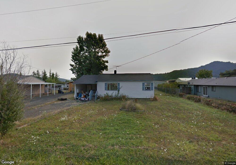
850 Landing St Sutherlin, OR 97479
Estimated Value: $201,000 - $282,000
2
Beds
1
Bath
832
Sq Ft
$289/Sq Ft
Est. Value
About This Home
This home is located at 850 Landing St, Sutherlin, OR 97479 and is currently estimated at $240,215, approximately $288 per square foot. 850 Landing St is a home located in Douglas County with nearby schools including East Sutherlin Primary School, West Sutherlin Intermediate School, and Sutherlin Middle School.
Ownership History
Date
Name
Owned For
Owner Type
Purchase Details
Closed on
Sep 18, 2024
Sold by
Jones William C
Bought by
William C Jones Revocable Living Trust and Jones
Current Estimated Value
Purchase Details
Closed on
Aug 19, 2016
Sold by
Mitchell Kelly A and Slight Daniel M
Bought by
Jones William C
Purchase Details
Closed on
Nov 2, 2009
Sold by
Slight Daniel
Bought by
Whitaker Gene C
Purchase Details
Closed on
Aug 15, 2006
Sold by
Whitaker Gene C and Whitaker Bonita R
Bought by
Whitaker Bonita R
Create a Home Valuation Report for This Property
The Home Valuation Report is an in-depth analysis detailing your home's value as well as a comparison with similar homes in the area
Home Values in the Area
Average Home Value in this Area
Purchase History
| Date | Buyer | Sale Price | Title Company |
|---|---|---|---|
| William C Jones Revocable Living Trust | -- | None Listed On Document | |
| Jones William C | $90,000 | Amerititle | |
| Whitaker Gene C | -- | Accommodation | |
| Whitaker Bonita R | -- | None Available |
Source: Public Records
Tax History Compared to Growth
Tax History
| Year | Tax Paid | Tax Assessment Tax Assessment Total Assessment is a certain percentage of the fair market value that is determined by local assessors to be the total taxable value of land and additions on the property. | Land | Improvement |
|---|---|---|---|---|
| 2025 | $1,212 | $97,911 | -- | -- |
| 2024 | $1,185 | $95,060 | -- | -- |
| 2023 | $1,151 | $92,292 | $0 | $0 |
| 2022 | $1,118 | $89,604 | $0 | $0 |
| 2021 | $1,086 | $86,995 | $0 | $0 |
| 2020 | $1,054 | $84,462 | $0 | $0 |
| 2019 | $1,024 | $82,002 | $0 | $0 |
| 2018 | $994 | $79,614 | $0 | $0 |
| 2017 | $1,016 | $77,296 | $0 | $0 |
| 2016 | $987 | $75,045 | $0 | $0 |
| 2015 | $961 | $72,860 | $0 | $0 |
| 2014 | $933 | $70,738 | $0 | $0 |
| 2013 | -- | $68,678 | $0 | $0 |
Source: Public Records
Map
Nearby Homes
- 142 S Comstock Ave
- 181 SW Hutchins St
- 1878 Trails End Ln
- 1688 W Central Ave
- 165 Robinson St
- 1907 W Duke Rd
- 226 Miller St
- 220 Miller St
- 401 N Comstock Ave
- 324 Dakota St
- 135 Elkton St
- 126 Coles Valley St
- 154 Coles Valley St
- 149 Coles Valley St
- 1660 Scardi Blvd
- 1716 Scardi Blvd Unit 174
- 788 Schoon Mountain Rd
- 427 S State St
- 351 Ashwood St
- 409 S State St
- 866 Landing St
- 838 Landing St
- 872 Landing St
- 816 Landing St
- 849 Landing St
- 859 Landing St
- 841 Landing St
- 878 Landing St
- 863 Landing St
- 813 Landing St
- 804 Landing St
- 801 Landing St
- 840 S Comstock Ave
- 852 S Comstock Ave
- 864 S Comstock Ave
- 840 S Comstock Rd
- 876 S Comstock Ave
- 1392 Airway Ave
- 905 Landing St
- 1379 Airway Ave