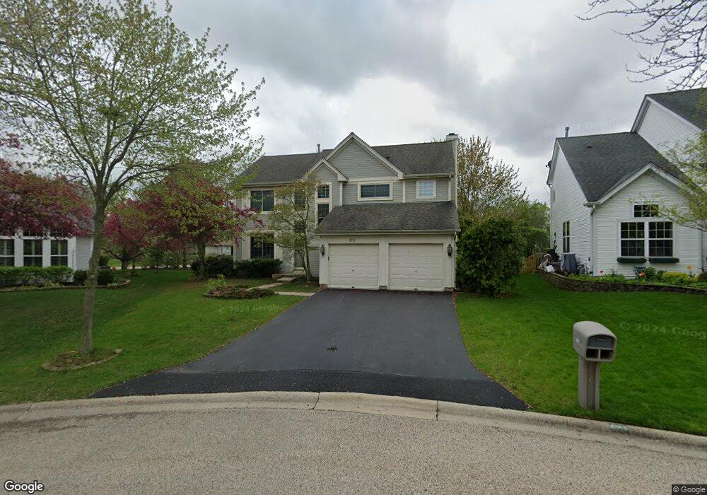
851 Bingham Ct Gurnee, IL 60031
Estimated Value: $437,000 - $493,000
4
Beds
3
Baths
2,305
Sq Ft
$202/Sq Ft
Est. Value
About This Home
This home is located at 851 Bingham Ct, Gurnee, IL 60031 and is currently estimated at $466,637, approximately $202 per square foot. 851 Bingham Ct is a home located in Lake County with nearby schools including Woodland Primary School, Woodland Elementary School, and Woodland Intermediate School.
Ownership History
Date
Name
Owned For
Owner Type
Purchase Details
Closed on
May 21, 1999
Sold by
Kaminsky Robert
Bought by
Mitchell Thomas and Mitchell Mimi
Current Estimated Value
Home Financials for this Owner
Home Financials are based on the most recent Mortgage that was taken out on this home.
Original Mortgage
$190,000
Outstanding Balance
$48,605
Interest Rate
6.92%
Estimated Equity
$418,032
Purchase Details
Closed on
Jan 17, 1994
Sold by
Northern Trust Bk Lake Forest Natl Assn
Bought by
Kaminsky Robert
Home Financials for this Owner
Home Financials are based on the most recent Mortgage that was taken out on this home.
Original Mortgage
$203,150
Interest Rate
7.02%
Create a Home Valuation Report for This Property
The Home Valuation Report is an in-depth analysis detailing your home's value as well as a comparison with similar homes in the area
Home Values in the Area
Average Home Value in this Area
Purchase History
| Date | Buyer | Sale Price | Title Company |
|---|---|---|---|
| Mitchell Thomas | $225,000 | Premier Title | |
| Kaminsky Robert | $144,000 | Chicago Title Insurance Co |
Source: Public Records
Mortgage History
| Date | Status | Borrower | Loan Amount |
|---|---|---|---|
| Open | Mitchell Thomas | $190,000 | |
| Previous Owner | Kaminsky Robert | $203,150 |
Source: Public Records
Tax History Compared to Growth
Tax History
| Year | Tax Paid | Tax Assessment Tax Assessment Total Assessment is a certain percentage of the fair market value that is determined by local assessors to be the total taxable value of land and additions on the property. | Land | Improvement |
|---|---|---|---|---|
| 2024 | $10,406 | $131,380 | $17,080 | $114,300 |
| 2023 | $9,815 | $113,889 | $14,806 | $99,083 |
| 2022 | $9,815 | $106,695 | $14,809 | $91,886 |
| 2021 | $8,870 | $102,414 | $14,215 | $88,199 |
| 2020 | $8,582 | $99,897 | $13,866 | $86,031 |
| 2019 | $8,337 | $96,996 | $13,463 | $83,533 |
| 2018 | $7,946 | $93,844 | $16,596 | $77,248 |
| 2017 | $7,919 | $91,154 | $16,120 | $75,034 |
| 2016 | $7,795 | $87,095 | $15,402 | $71,693 |
| 2015 | $7,588 | $82,601 | $14,607 | $67,994 |
| 2014 | $7,655 | $83,827 | $14,427 | $69,400 |
| 2012 | $7,527 | $84,468 | $14,537 | $69,931 |
Source: Public Records
Map
Nearby Homes
- 920 Vose Dr Unit 304
- 920 Vose Dr Unit 106
- 920 Vose Dr Unit 105
- 6141 Crossland Blvd
- 914 Vose Dr
- 917 Vose Dr Unit 304
- 776 Chandler Rd
- 6121 Brookstone Place
- 741 Colby Ct Unit U42
- 690 Chandler Rd Unit 102
- 690 Chandler Rd Unit 207
- 690 Chandler Rd Unit 305
- 650 Whitney Ct Unit 203
- 32956 N Ashley Dr
- 651 White Ct
- 6296 Doral Dr
- 6359 Doral Dr
- 638 Dordan Ct
- 711 Creekside Cir Unit 103
- 6161 Oakmont Ln
- 855 Bingham Ct
- 843 Bingham Ct
- 903 Adderly Ln
- 839 Bingham Ct
- 850 Adderly Ln
- 846 Adderly Ln
- 1014 Farwell Ct Unit 510
- 1012 Farwell Ct Unit 509
- 1010 Farwell Ct Unit 508
- 1008 Farwell Ct Unit 507
- 1004 Farwell Ct Unit 505
- 1002 Farwell Ct Unit 504
- 1000 Farwell Ct Unit 503
- 1000 Farwell Ct Unit 1000
- 835 Bingham Ct
- 842 Adderly Ln
- 1006 Farwell Ct Unit 506
- 1006 Farwell Ct Unit 1006
- 907 Adderly Ln
- 904 Campbell Dr Unit U488