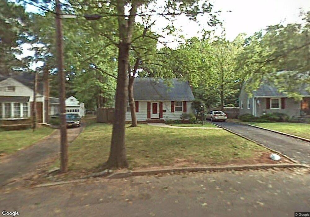
852 Adam Cir Plainfield, NJ 07062
Estimated Value: $423,915 - $490,000
Studio
--
Bath
852
Sq Ft
$550/Sq Ft
Est. Value
About This Home
This home is located at 852 Adam Cir, Plainfield, NJ 07062 and is currently estimated at $468,229, approximately $549 per square foot. 852 Adam Cir is a home located in Union County with nearby schools including Frederic W. Cook School, Emerson Community School, and Maxson Middle School.
Ownership History
Date
Name
Owned For
Owner Type
Purchase Details
Closed on
Jan 5, 2016
Sold by
Robins Frank
Bought by
Rokins Frank and Rokins Wanda
Current Estimated Value
Purchase Details
Closed on
Jul 1, 2004
Sold by
Thomas Deborah
Bought by
Rokins Frank
Home Financials for this Owner
Home Financials are based on the most recent Mortgage that was taken out on this home.
Original Mortgage
$202,080
Interest Rate
6.28%
Create a Home Valuation Report for This Property
The Home Valuation Report is an in-depth analysis detailing your home's value as well as a comparison with similar homes in the area
Home Values in the Area
Average Home Value in this Area
Purchase History
| Date | Buyer | Sale Price | Title Company |
|---|---|---|---|
| Rokins Frank | $100 | -- | |
| Rokins Frank | $252,600 | -- |
Source: Public Records
Mortgage History
| Date | Status | Borrower | Loan Amount |
|---|---|---|---|
| Previous Owner | Rokins Frank | $202,080 |
Source: Public Records
Tax History
| Year | Tax Paid | Tax Assessment Tax Assessment Total Assessment is a certain percentage of the fair market value that is determined by local assessors to be the total taxable value of land and additions on the property. | Land | Improvement |
|---|---|---|---|---|
| 2025 | $9,946 | $113,900 | $57,200 | $56,700 |
| 2024 | $9,848 | $113,900 | $57,200 | $56,700 |
| 2023 | $9,848 | $113,900 | $57,200 | $56,700 |
| 2022 | $9,635 | $113,900 | $57,200 | $56,700 |
| 2021 | $9,551 | $113,900 | $57,200 | $56,700 |
| 2020 | $9,523 | $113,900 | $57,200 | $56,700 |
| 2019 | $9,523 | $113,900 | $57,200 | $56,700 |
| 2018 | $9,324 | $113,900 | $57,200 | $56,700 |
| 2017 | $9,096 | $113,900 | $57,200 | $56,700 |
| 2016 | $8,910 | $113,900 | $57,200 | $56,700 |
| 2015 | $8,647 | $113,900 | $57,200 | $56,700 |
| 2014 | $8,413 | $113,900 | $57,200 | $56,700 |
Source: Public Records
Map
Nearby Homes
- 848 Adam Cir
- 904 Sterling St
- 837 Coolidge St Unit 39
- 930 Cushing Place Unit 32
- 917 Fernwood Ave Unit 23
- 835 Dixie Ln Unit 37
- 807 Berkeley Ave Unit 9
- 1464 Jean Terrace Unit 68
- 1224 Sunnyfield Ln
- 519 Terrill Rd
- 603 Terrill Rd
- 481 Terrill Rd
- 1231 Sunnyfield Ln
- 15 La Grande Ave
- 45 Kempshall Terrace
- 771 Ravine Rd
- 767 Ravine Rd Unit 73
- 633 Woodland Ave Unit 37
- 1365 Columbia Ave Unit 69
- 1107-11 North Ave
- 850 Adam Cir
- 854 Adam Cir
- 856 Adam Cir
- 855 855 Adam Cir
- 1245 Oxford Ave Unit 49
- 1251 Oxford Ave Unit 53
- 853 Adam Cir Unit 57
- 1235 Oxford Ave Unit 43
- 846 Adam Cir
- 858 Adam Cir
- 1255 Oxford Ave Unit 61
- 849 Adam Cir Unit 51
- 859 Adam Cir Unit 61
- 844 Adam Cir
- 860 Adam Cir
- 845 Adam Cir Unit 47
- 1263 Oxford Ave Unit 67
- 1227 Oxford Ave Unit 33
- 1229 Oxford Ave
- 850-54 Coolidge St
Your Personal Tour Guide
Ask me questions while you tour the home.