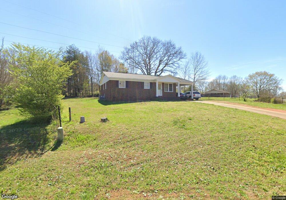
853 Applegate Dr Shelby, NC 28152
Estimated Value: $112,886 - $184,000
--
Bed
--
Bath
1,073
Sq Ft
$143/Sq Ft
Est. Value
About This Home
This home is located at 853 Applegate Dr, Shelby, NC 28152 and is currently estimated at $152,972, approximately $142 per square foot. 853 Applegate Dr is a home located in Cleveland County with nearby schools including Township Three Elementary School, Crest Middle School, and Crest High School.
Ownership History
Date
Name
Owned For
Owner Type
Purchase Details
Closed on
Feb 28, 2025
Sold by
First Choice Properties
Bought by
Premium Property Group Llc
Current Estimated Value
Purchase Details
Closed on
Feb 3, 2011
Sold by
Citimortgage Inc
Bought by
First Choice Food Service Of Va Inc
Purchase Details
Closed on
Aug 2, 2010
Sold by
Hopper Ocie M
Bought by
Citimortgage Inc
Create a Home Valuation Report for This Property
The Home Valuation Report is an in-depth analysis detailing your home's value as well as a comparison with similar homes in the area
Home Values in the Area
Average Home Value in this Area
Purchase History
| Date | Buyer | Sale Price | Title Company |
|---|---|---|---|
| Premium Property Group Llc | $1,000,000 | None Listed On Document | |
| Premium Property Group Llc | $1,000,000 | None Listed On Document | |
| First Choice Food Service Of Va Inc | $13,500 | None Available | |
| Citimortgage Inc | $42,945 | None Available |
Source: Public Records
Tax History Compared to Growth
Tax History
| Year | Tax Paid | Tax Assessment Tax Assessment Total Assessment is a certain percentage of the fair market value that is determined by local assessors to be the total taxable value of land and additions on the property. | Land | Improvement |
|---|---|---|---|---|
| 2025 | $1,295 | $130,161 | $14,968 | $115,193 |
| 2024 | $641 | $51,150 | $5,346 | $45,804 |
| 2023 | $641 | $51,150 | $5,346 | $45,804 |
| 2022 | $638 | $51,150 | $5,346 | $45,804 |
| 2021 | $641 | $51,150 | $5,346 | $45,804 |
| 2020 | $678 | $52,814 | $5,346 | $47,468 |
| 2019 | $678 | $52,814 | $5,346 | $47,468 |
| 2018 | $677 | $52,814 | $5,346 | $47,468 |
| 2017 | $660 | $52,814 | $5,346 | $47,468 |
| 2016 | $661 | $52,814 | $5,346 | $47,468 |
| 2015 | $724 | $61,057 | $5,346 | $55,711 |
| 2014 | $724 | $61,057 | $5,346 | $55,711 |
Source: Public Records
Map
Nearby Homes
- 137 Northeastern Dr
- 135 Northeastern Dr
- 130 Northeastern Dr
- 128 Northeastern Dr
- 106 Westwind Dr
- 104 Westwind Dr
- 114 Westwind Dr
- 118 Westwind Dr
- 109 Westwind Dr
- 113 Westwind Dr
- 117 Westwind Dr
- 101 Westwind Dr
- 306 Alden Ct
- 108 Northeastern Dr
- 109 Northeastern Dr
- 302 Alden Ct
- 305 Alden Ct
- 303 Alden Ct
- 301 Alden Ct
- 220 Alden Ct
- 2043 Greenoak Dr
- 2043 Greenoak Dr Unit 46
- 2041 Greenoak Dr
- 2043 Green Oak Dr
- 851 Applegate Dr
- 2037 Green Oak Dr
- 2045 Green Oak Dr
- 2038 Green Oak Dr
- 850 Applegate Dr
- 2042 Green Oak Dr
- 2047 Green Oak Dr
- 2044 Green Oak Dr
- 2212 Melrose Dr
- 2034 Green Oak Dr
- 2049 Green Oak Dr
- 307 Cedarwood Dr
- 2070 Cottonwood Dr
- 2032 Green Oak Dr
- 308 Cedarwood Dr
- 305 Cedarwood Dr