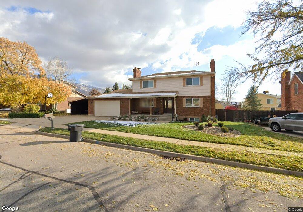
854 Raymond Rd Kaysville, UT 84037
Estimated Value: $710,000 - $795,000
3
Beds
2
Baths
2,985
Sq Ft
$253/Sq Ft
Est. Value
About This Home
This home is located at 854 Raymond Rd, Kaysville, UT 84037 and is currently estimated at $753,977, approximately $252 per square foot. 854 Raymond Rd is a home located in Davis County with nearby schools including H.C. Burton Elementary School, Kaysville Junior High School, and Davis High School.
Ownership History
Date
Name
Owned For
Owner Type
Purchase Details
Closed on
Dec 29, 2015
Sold by
Ripplinger Randall E and Ripplinger Linda Lee
Bought by
Ripplinger Linda L and Ripplinger Revocable Living Trust
Current Estimated Value
Purchase Details
Closed on
Oct 23, 2000
Sold by
Benson Ann M
Bought by
Benson Ann M and Benson Scott Douglas
Purchase Details
Closed on
Aug 2, 1996
Sold by
Harris Lowell L and Harris Janet L
Bought by
Ripplinger Randall R and Ripplinger Linda Lee
Create a Home Valuation Report for This Property
The Home Valuation Report is an in-depth analysis detailing your home's value as well as a comparison with similar homes in the area
Home Values in the Area
Average Home Value in this Area
Purchase History
| Date | Buyer | Sale Price | Title Company |
|---|---|---|---|
| Ripplinger Linda L | -- | -- | |
| Benson Ann M | -- | Brighton Title | |
| Ripplinger Randall R | -- | Associated Title Company |
Source: Public Records
Tax History Compared to Growth
Tax History
| Year | Tax Paid | Tax Assessment Tax Assessment Total Assessment is a certain percentage of the fair market value that is determined by local assessors to be the total taxable value of land and additions on the property. | Land | Improvement |
|---|---|---|---|---|
| 2024 | $3,656 | $374,550 | $205,422 | $169,128 |
| 2023 | $3,420 | $635,000 | $306,050 | $328,950 |
| 2022 | $3,559 | $360,800 | $150,579 | $210,221 |
| 2021 | $3,322 | $509,000 | $241,157 | $267,843 |
| 2020 | $3,019 | $448,000 | $204,887 | $243,113 |
| 2019 | $2,975 | $436,000 | $186,377 | $249,623 |
| 2018 | $2,775 | $401,000 | $129,326 | $271,674 |
| 2016 | $2,376 | $178,805 | $54,317 | $124,488 |
| 2015 | $2,263 | $161,975 | $54,317 | $107,658 |
| 2014 | $2,263 | $171,646 | $54,317 | $117,329 |
| 2013 | -- | $156,837 | $45,038 | $111,799 |
Source: Public Records
Map
Nearby Homes
- 947 E Green Rd
- 998 E Country Rd
- 636 E 100 N
- 289 N 700 E
- 380 N 1000 E
- 1236 E 100 S
- 272 Pin Oak Ln
- 1351 E 400 S
- 331 E 100 S
- 1779 250 N Unit 29-R
- 309 E 100 S
- 1730 250 N Unit 23-R
- 1616 250 N Unit 26-R
- 1425 250 N
- 399 Stirling Dr E
- 362 Glen Cir
- 481 E Laurelwood Dr S
- 617 E Whisper Creek Dr
- 673 S Main St
- 425 E 500 N
- 842 E Raymond Rd
- 870 Raymond Rd
- 842 Raymond Rd
- 841 E Village Way
- 855 E Village Way
- 39 S Village Way
- 882 Raymond Rd
- 21 S Village Way
- 14 Heartwood St
- 821 Raymond Rd
- 869 E Village Way
- 839 Raymond Rd
- 875 Raymond Rd
- 906 Raymond Rd
- 906 E Raymond Rd
- 30 Heartwood St
- 31 N Heartwood St
- 31 Heartwood St
- 868 Heartwood Cir
- 915 Raymond Rd