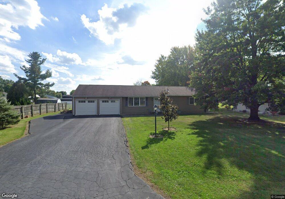
855 Beardsley Rd Galion, OH 44833
Estimated Value: $199,896 - $311,000
3
Beds
2
Baths
1,222
Sq Ft
$189/Sq Ft
Est. Value
About This Home
This home is located at 855 Beardsley Rd, Galion, OH 44833 and is currently estimated at $230,724, approximately $188 per square foot. 855 Beardsley Rd is a home located in Crawford County with nearby schools including Galion Primary School, Galion Intermediate School, and Galion Middle School.
Ownership History
Date
Name
Owned For
Owner Type
Purchase Details
Closed on
Mar 24, 2009
Sold by
Wolf Harley R and Wolf Paulette J
Bought by
Wolf Harley R and Wolf Amie C
Current Estimated Value
Home Financials for this Owner
Home Financials are based on the most recent Mortgage that was taken out on this home.
Original Mortgage
$95,000
Outstanding Balance
$60,343
Interest Rate
5.11%
Mortgage Type
Purchase Money Mortgage
Estimated Equity
$170,381
Purchase Details
Closed on
Jan 9, 2004
Bought by
Wolf Harley R and Wolf Amie C
Create a Home Valuation Report for This Property
The Home Valuation Report is an in-depth analysis detailing your home's value as well as a comparison with similar homes in the area
Purchase History
| Date | Buyer | Sale Price | Title Company |
|---|---|---|---|
| Wolf Harley R | -- | -- | |
| Wolf Harley R | -- | -- |
Source: Public Records
Mortgage History
| Date | Status | Borrower | Loan Amount |
|---|---|---|---|
| Open | Wolf Harley R | $95,000 |
Source: Public Records
Tax History Compared to Growth
Tax History
| Year | Tax Paid | Tax Assessment Tax Assessment Total Assessment is a certain percentage of the fair market value that is determined by local assessors to be the total taxable value of land and additions on the property. | Land | Improvement |
|---|---|---|---|---|
| 2024 | $1,999 | $55,550 | $4,730 | $50,820 |
| 2023 | $2,003 | $38,980 | $4,730 | $34,250 |
| 2022 | $1,845 | $38,980 | $4,730 | $34,250 |
| 2021 | $1,889 | $38,980 | $4,730 | $34,250 |
| 2020 | $1,466 | $31,120 | $4,730 | $26,390 |
| 2019 | $1,508 | $31,120 | $4,730 | $26,390 |
| 2018 | $1,506 | $31,120 | $4,730 | $26,390 |
| 2017 | $1,434 | $28,460 | $4,730 | $23,730 |
| 2016 | $1,385 | $28,460 | $4,730 | $23,730 |
| 2015 | $1,382 | $28,460 | $4,730 | $23,730 |
| 2014 | $1,563 | $31,390 | $4,730 | $26,660 |
| 2013 | $1,563 | $31,390 | $4,730 | $26,660 |
Source: Public Records
Map
Nearby Homes
- 0 Knorr Rd Unit 9070148
- 1527 Fairview Rd
- 1500 N Market St
- 0 Buehler St Parcel 6
- 898 Fairview Ave
- 1405 State Route 598
- 329 Hetrick Dr
- 710 N Liberty St
- 310 E Summit St
- 271 Westgate Rd
- 325 Sherman St
- 367 N Columbus St
- 147 Erie St
- 360 N Columbus St
- 244 E Payne Ave
- 321 N Market St
- 281 N Union St
- 134 N Riblet St
- 418 Gill Ave
- 1342 State Route 61
- 845 Beardsley Rd
- 1440 Knorr Rd
- 1430 Knorr Rd
- 825 Beardsley Rd
- 780 E Brandt Rd
- 1420 Knorr Rd
- 1460 Knorr Rd
- 858 Beardsley Rd
- 828 Beardsley Rd
- 760 E Brandt Rd
- 1400 Knorr Rd
- 805 Beardsley Rd
- 1470 Knorr Rd
- 808 Beardsley Rd
- 750 E Brandt Rd
- 1480 Knorr Rd
- 777 Beardsley Rd
- 800 Beardsley Rd
- 845 Haymond St
- 825 Haymond St