Estimated Value: $488,000 - $577,000
4
Beds
3
Baths
3,000
Sq Ft
$182/Sq Ft
Est. Value
About This Home
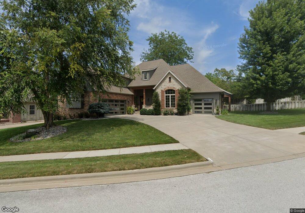
This home is located at 855 E Grafton Dr, Nixa, MO 65714 and is currently estimated at $546,816, approximately $182 per square foot. 855 E Grafton Dr is a home located in Christian County with nearby schools including High Pointe Elementary School, Summit Intermediate School, and Nixa Junior High School.
Ownership History
Date
Name
Owned For
Owner Type
Purchase Details
Closed on
Jan 14, 2011
Sold by
Ramsey Building Company Llc
Bought by
Burke Shaun A and Burke Kimberly R
Current Estimated Value
Home Financials for this Owner
Home Financials are based on the most recent Mortgage that was taken out on this home.
Original Mortgage
$288,000
Outstanding Balance
$185,883
Interest Rate
4%
Mortgage Type
Adjustable Rate Mortgage/ARM
Estimated Equity
$360,933
Purchase Details
Closed on
Mar 31, 2008
Sold by
Cc Land Partners Llc
Bought by
Ramsey Building Co Llc
Create a Home Valuation Report for This Property
The Home Valuation Report is an in-depth analysis detailing your home's value as well as a comparison with similar homes in the area
Home Values in the Area
Average Home Value in this Area
Purchase History
| Date | Buyer | Sale Price | Title Company |
|---|---|---|---|
| Burke Shaun A | -- | None Available | |
| Ramsey Building Co Llc | -- | None Available |
Source: Public Records
Mortgage History
| Date | Status | Borrower | Loan Amount |
|---|---|---|---|
| Open | Burke Shaun A | $288,000 |
Source: Public Records
Tax History
| Year | Tax Paid | Tax Assessment Tax Assessment Total Assessment is a certain percentage of the fair market value that is determined by local assessors to be the total taxable value of land and additions on the property. | Land | Improvement |
|---|---|---|---|---|
| 2025 | $4,282 | $73,380 | -- | -- |
| 2024 | $4,282 | $68,720 | -- | -- |
| 2023 | $4,282 | $68,720 | $0 | $0 |
| 2022 | $4,200 | $67,300 | $0 | $0 |
| 2021 | $4,202 | $67,300 | $0 | $0 |
| 2020 | $4,021 | $61,470 | $0 | $0 |
| 2019 | $4,021 | $61,470 | $0 | $0 |
| 2018 | $3,745 | $61,470 | $0 | $0 |
| 2017 | $3,745 | $61,470 | $0 | $0 |
| 2016 | $3,688 | $61,470 | $0 | $0 |
| 2015 | $3,693 | $61,470 | $61,470 | $0 |
| 2014 | $3,599 | $61,410 | $0 | $0 |
| 2013 | $36 | $61,410 | $0 | $0 |
| 2011 | $36 | $122,820 | $0 | $0 |
Source: Public Records
Map
Nearby Homes
- 861 Bantry Ct
- 1419 Rich Hill Cir
- 871 Galway Ct
- 867 E Edenmore Cir
- 856 E Edenmore Cir
- 824 E Kings Mead Cir Unit 1
- 815 E Beaufort St
- 842 E Abbey Ct
- 1435 N Rockingham Ave
- 714 N Fox Hill Cir
- Lot 40 the Village of Cloverhill
- Lot 43 the Village of Cloverhill
- Lot 49 the Village of Cloverhill
- 1373 N Rockingham Ave
- Lot 52 the Village of Cloverhill
- Lot 45 the Village of Cloverhill
- Lot 47 the Village of Cloverhill
- Lot 42 the Village of Cloverhill
- Lot 51 the Village of Cloverhill
- Lot 48 the Village of Cloverhill
- 858 E Grafton Dr
- 851 E Grafton Dr
- 856 E Grafton Dr
- 860 E Grafton Dr
- 854 E Grafton Dr
- 852 E Grafton Dr
- 849 E Grafton Dr
- 850 E Grafton Dr
- 860 Bantry Ct
- 847 E Grafton Dr
- 854 E Rush Ct
- 853 E Rush Ct
- 1413 Wexford Way
- 848 E Grafton Dr
- 1412 Rich Hill Cir
- 1411 N Wexford Way
- 1414 N Rich Hill Cir
- 845 E Grafton Dr
- 846 E Grafton Dr
- 852 E Rush Ct
Your Personal Tour Guide
Ask me questions while you tour the home.