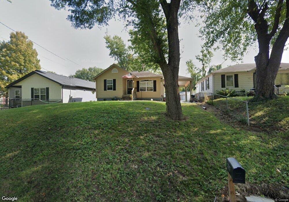
858 Summit Ave Collinsville, IL 62234
Estimated Value: $129,000 - $152,000
3
Beds
1
Bath
861
Sq Ft
$163/Sq Ft
Est. Value
About This Home
This home is located at 858 Summit Ave, Collinsville, IL 62234 and is currently estimated at $139,950, approximately $162 per square foot. 858 Summit Ave is a home located in Madison County with nearby schools including Summit Elementary School, Dorris Intermediate School, and Collinsville Middle School.
Ownership History
Date
Name
Owned For
Owner Type
Purchase Details
Closed on
Dec 15, 2006
Sold by
Huster William and Huster Diana
Bought by
Distler Eran
Current Estimated Value
Home Financials for this Owner
Home Financials are based on the most recent Mortgage that was taken out on this home.
Original Mortgage
$98,900
Outstanding Balance
$59,294
Interest Rate
6.36%
Mortgage Type
Purchase Money Mortgage
Estimated Equity
$80,656
Purchase Details
Closed on
Jun 13, 2006
Sold by
Soehlke Mary Jane and Jeanne Piesbergen C
Bought by
Huster William and Huster Diana
Home Financials for this Owner
Home Financials are based on the most recent Mortgage that was taken out on this home.
Original Mortgage
$55,000
Interest Rate
7.3%
Mortgage Type
Purchase Money Mortgage
Purchase Details
Closed on
Dec 30, 2004
Sold by
Soehlke Leonard E and Soehlke Stella M
Bought by
Soehlke Mary Jane and Jeanne Piesbergern C
Create a Home Valuation Report for This Property
The Home Valuation Report is an in-depth analysis detailing your home's value as well as a comparison with similar homes in the area
Home Values in the Area
Average Home Value in this Area
Purchase History
| Date | Buyer | Sale Price | Title Company |
|---|---|---|---|
| Distler Eran | $99,000 | Abstracts & Titles Inc | |
| Huster William | $23,000 | Abstracts & Titles Inc | |
| Soehlke Mary Jane | -- | -- |
Source: Public Records
Mortgage History
| Date | Status | Borrower | Loan Amount |
|---|---|---|---|
| Open | Distler Eran | $98,900 | |
| Previous Owner | Huster William | $55,000 |
Source: Public Records
Tax History Compared to Growth
Tax History
| Year | Tax Paid | Tax Assessment Tax Assessment Total Assessment is a certain percentage of the fair market value that is determined by local assessors to be the total taxable value of land and additions on the property. | Land | Improvement |
|---|---|---|---|---|
| 2024 | $2,149 | $39,620 | $7,200 | $32,420 |
| 2023 | $2,149 | $36,670 | $6,660 | $30,010 |
| 2022 | $2,019 | $32,910 | $5,960 | $26,950 |
| 2021 | $1,721 | $30,920 | $5,600 | $25,320 |
| 2020 | $1,640 | $29,500 | $5,340 | $24,160 |
| 2019 | $1,582 | $28,490 | $5,160 | $23,330 |
| 2018 | $1,533 | $26,990 | $4,870 | $22,120 |
| 2017 | $1,526 | $26,450 | $4,770 | $21,680 |
| 2016 | $1,598 | $26,450 | $4,770 | $21,680 |
| 2015 | $1,480 | $25,770 | $4,650 | $21,120 |
| 2014 | $1,480 | $25,770 | $4,650 | $21,120 |
| 2013 | $1,480 | $25,770 | $4,650 | $21,120 |
Source: Public Records
Map
Nearby Homes
- 123 Elliot St
- 510 N Combs Ave
- 580 N Guernsey St
- 0 Strong Ave
- 0 Elm St
- 300 N Combs Ave
- 123 W Wickliffe Ave
- 419 Bell St
- 221 N Hesperia St Unit 221 A and 221 B
- 1121 Carraway Ct
- 100 Debbie Dr
- 617 N Morrison Ave
- 506 W Clay St
- 119 N Hesperia St
- 5 Brookwood Dr
- 611 W Main St
- 205 Audrey Ave
- 108 Westridge Dr
- 22 Brookwood Dr
- 125 S Hesperia St