


86 Bingham Rd Gilmanton, NH 03237
Estimated payment $3,133/month
Highlights
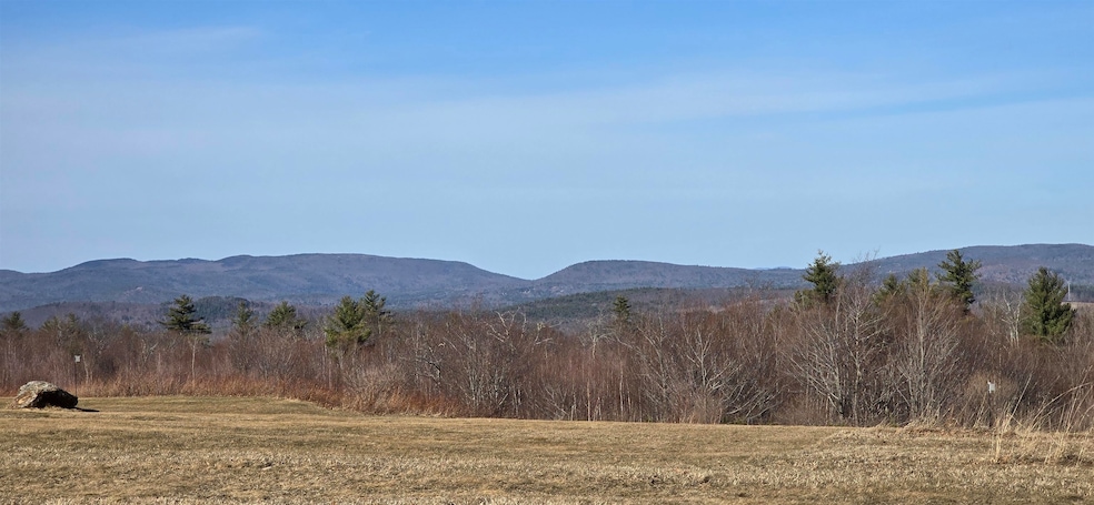
- 14.75 Acre Lot
- Wooded Lot
- Level Lot
- Mountain View
- Trails
About This Lot
Pristine 14.75 acre view lot in prime location offering approximately 4+ acres of fairly level usable field, old New England stone walls, and enchanting woods with plenty of hard wood. Beautiful mountain view. An extraordinary piece of land with nearby hiking and snowmobile trails and wildlife abound. Ideal for custom build in area of fine homes! Underground utilities. Agent interest.
Property Details
Property Type
- Land
Est. Annual Taxes
- $33
Lot Details
- 14.75 Acre Lot
- Level Lot
- Wooded Lot
- Property is zoned Rural
Property Views
- Mountain Views
Schools
- Gilmanton Elementary School
- Gilmanton Middle School
- Gilford High School
Utilities
- Well Required
- Septic Needed
Community Details
- Trails
- Electricity Available at Street
Listing and Financial Details
- Tax Lot 2
- Assessor Parcel Number 424
Map
Home Values in the Area
Average Home Value in this Area
Tax History
| Year | Tax Paid | Tax Assessment Tax Assessment Total Assessment is a certain percentage of the fair market value that is determined by local assessors to be the total taxable value of land and additions on the property. | Land | Improvement |
|---|---|---|---|---|
| 2024 | $33 | $2,237 | $2,237 | $0 |
| 2023 | $32 | $1,384 | $1,384 | $0 |
| 2022 | $41 | $1,715 | $1,715 | $0 |
| 2021 | $48 | $2,023 | $2,023 | $0 |
| 2020 | $51 | $2,205 | $2,205 | $0 |
| 2019 | $51 | $2,219 | $2,219 | $0 |
| 2018 | $53 | $2,084 | $2,084 | $0 |
| 2017 | $52 | $2,097 | $2,097 | $0 |
| 2016 | $52 | $2,187 | $2,187 | $0 |
| 2015 | $56 | $2,146 | $2,146 | $0 |
| 2014 | $48 | $2,105 | $2,105 | $0 |
| 2013 | $48 | $2,252 | $2,252 | $0 |
Property History
| Date | Event | Price | List to Sale | Price per Sq Ft |
|---|---|---|---|---|
| 11/05/2025 11/05/25 | Price Changed | $595,000 | +3.5% | -- |
| 10/08/2025 10/08/25 | Price Changed | $575,000 | -4.2% | -- |
| 09/29/2025 09/29/25 | For Sale | $600,000 | 0.0% | -- |
| 09/21/2025 09/21/25 | Off Market | $600,000 | -- | -- |
| 09/03/2025 09/03/25 | Price Changed | $600,000 | -4.0% | -- |
| 08/04/2025 08/04/25 | Price Changed | $625,000 | -3.8% | -- |
| 07/11/2025 07/11/25 | Price Changed | $650,000 | -3.7% | -- |
| 04/16/2025 04/16/25 | Price Changed | $675,000 | -2.9% | -- |
| 03/20/2025 03/20/25 | For Sale | $695,000 | -- | -- |
Source: PrimeMLS
MLS Number: 5032827
APN: GILM-000424-000000-002000
Disclaimer: Certain information contained herein is derived from information provided by parties other than Homes.com. All information provided is deemed reliable, but is not guaranteed to be accurate and should be independently verified.
![]() Copyright 2025 PrimeMLS, Inc. All rights reserved. This information is deemed reliable, but not guaranteed. The data relating to real estate displayed on this display comes in part from the IDX Program of PrimeMLS. The information being provided is for consumers’ personal, non-commercial use and may not be used for any purpose other than to identify prospective properties consumers may be interested in purchasing.
Copyright 2025 PrimeMLS, Inc. All rights reserved. This information is deemed reliable, but not guaranteed. The data relating to real estate displayed on this display comes in part from the IDX Program of PrimeMLS. The information being provided is for consumers’ personal, non-commercial use and may not be used for any purpose other than to identify prospective properties consumers may be interested in purchasing.
- 0 Bingham Rd Unit 5000
- 51 Bingham Rd
- 52 Meeting House Rd
- 000 Thistle Rd Unit 48
- 92 Loon Pond Rd
- 419-24 Meeting House Rd
- 0 Stone Rd Unit 62
- 22 Joe Jones Rd
- 628 Province Rd
- 000 Province Rd Unit 67
- 71 Secord Rd
- 0 River Rd Unit 4 5062390
- 000 Pocumtuck Way Unit 35
- 4 Penobscott Path
- 28 Abnaki Path
- 174 Lakeshore Dr
- 19 Abnaki Path
- 260 Garland Rd
- 376 White Oak Rd
- 15 Church St
- 240 S Barnstead Rd Unit A
- 4 N Shore Dr
- 141 Main St Unit 2
- 53 Carpenter Rd
- 23 Clough Pond Rd
- 9 Depot Rd Unit Carriage House
- 631 Prospect Mountain Rd Unit 2
- 17 Orchard Hill Rd Unit Orchard Hill
- 605 Province Rd
- 15 Mark Dr
- 76 Judy's Way Unit 76JW
- 65 Provencal Rd Unit 306
- 65 Provencal Rd Unit 106
- 65 Provencal Rd
- 67 Provencal Rd Unit 67-302
- 501 Bean Hill Rd Unit 1 bedroom for rent
- 244 Province St
- 93 Baldwin St Unit 5
- 120 Saltmarsh Pond Rd Unit 1
- 118 Woodlands Rd
