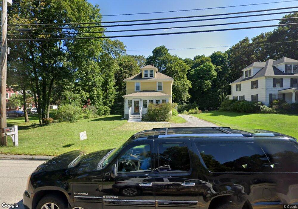
86 Franklin St Wrentham, MA 02093
Estimated Value: $558,000 - $612,411
3
Beds
2
Baths
1,512
Sq Ft
$392/Sq Ft
Est. Value
About This Home
This home is located at 86 Franklin St, Wrentham, MA 02093 and is currently estimated at $592,353, approximately $391 per square foot. 86 Franklin St is a home located in Norfolk County with nearby schools including Delaney Elementary School and Charles E Roderick.
Ownership History
Date
Name
Owned For
Owner Type
Purchase Details
Closed on
Jan 2, 2007
Sold by
Williams Lori
Bought by
Will Deborah E and Pruell Thomas J
Current Estimated Value
Home Financials for this Owner
Home Financials are based on the most recent Mortgage that was taken out on this home.
Original Mortgage
$223,200
Outstanding Balance
$133,299
Interest Rate
6.29%
Mortgage Type
Purchase Money Mortgage
Estimated Equity
$459,054
Create a Home Valuation Report for This Property
The Home Valuation Report is an in-depth analysis detailing your home's value as well as a comparison with similar homes in the area
Home Values in the Area
Average Home Value in this Area
Purchase History
| Date | Buyer | Sale Price | Title Company |
|---|---|---|---|
| Will Deborah E | $279,000 | -- |
Source: Public Records
Mortgage History
| Date | Status | Borrower | Loan Amount |
|---|---|---|---|
| Open | Will Deborah E | $223,200 | |
| Closed | Will Deborah E | $45,800 |
Source: Public Records
Tax History Compared to Growth
Tax History
| Year | Tax Paid | Tax Assessment Tax Assessment Total Assessment is a certain percentage of the fair market value that is determined by local assessors to be the total taxable value of land and additions on the property. | Land | Improvement |
|---|---|---|---|---|
| 2025 | $5,929 | $511,600 | $263,600 | $248,000 |
| 2024 | $5,640 | $470,000 | $263,600 | $206,400 |
| 2023 | $5,433 | $430,500 | $230,800 | $199,700 |
| 2022 | $5,478 | $400,700 | $235,700 | $165,000 |
| 2021 | $5,238 | $372,300 | $209,700 | $162,600 |
| 2020 | $4,584 | $321,700 | $160,100 | $161,600 |
| 2019 | $4,366 | $309,200 | $152,500 | $156,700 |
| 2018 | $4,088 | $287,100 | $152,500 | $134,600 |
| 2017 | $3,859 | $270,800 | $149,600 | $121,200 |
| 2016 | $3,706 | $259,500 | $145,200 | $114,300 |
| 2015 | $3,601 | $240,400 | $139,600 | $100,800 |
| 2014 | $3,546 | $231,600 | $134,300 | $97,300 |
Source: Public Records
Map
Nearby Homes
- 10 Nature View Dr
- 15 Nature View Dr
- 270 Dedham St
- 1 Lorraine Metcalf Dr
- 131 Creek St Unit 7
- 570 Franklin St
- 362 East St
- 11 Earle Stewart Ln
- Lot 3 - 14 Earle Stewart Ln
- Lot 1 - Blueberry 2 Car Plan at King Philip Estates
- Lot 8 - Blueberry 2 Car Plan at King Philip Estates
- Lot 6 - Blueberry 3 Car Plan at King Philip Estates
- Lot 2 - Camden 2 Car Plan at King Philip Estates
- Lot 7 - Cedar Plan at King Philip Estates
- Lot 4 - Hemingway 2 Car Plan at King Philip Estates
- Lot 3 - Blueberry 2 Car Plan at King Philip Estates
- 319 Taunton St
- 246 Forest Grove Ave
- 50 Reed Fulton Ave Unit Lot 61
- 3 Oak Rd