
Seller's Agent in 2025
Sinead Butler
Coldwell Banker Realty - Cohasset
(617) 721-4061
5 in this area
20 Total Sales
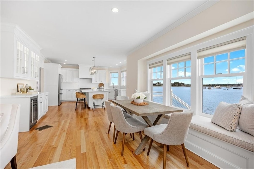
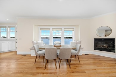
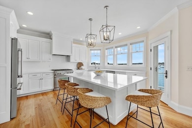
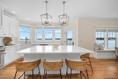
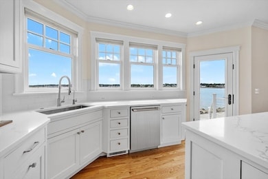
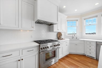
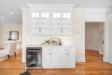
BROKERS LUNCHEON STILL HAPPENING TODAY, FRIDAY 11TH, 12PM. OCEANFRONT! This rare and STUNNING custom built property offers magnificent panoramic views of Scituate Harbor, the Atlantic & Lighthouse, from sunrise to sunset. Designed to maximize its spectacular setting, the Main House first floor offers an open floor plan ideal for entertaining including Living, Dining & Gourmet Kitchen with Thermador appliances, Quartz countertops & Wine/Beverage Bar. Amazing expansive new Patio & Deck are off the kitchen, directly on the ocean.The 2nd floor boasts an exquisite Primary Suite with generous bedroom, bath & new walk-in closet. A guest room, full bath & laundry room complete the second floor with majestic ocean views from every room. The entire third floor is one large bedroom, closet & window seat, perfect for boat watching. The separate Guest House/In-Law Apartment has sweeping ocean views with Living, Dining, Kitchenette, Balcony & oversized garage. 10 parking spaces!
Last Agent to Sell the Property
Coldwell Banker Realty - Cohasset License #455022150 Listed on: 07/09/2025
| Date | Type | Sale Price | Title Company |
|---|---|---|---|
| Quit Claim Deed | $2,350,000 | -- | |
| Quit Claim Deed | $2,350,000 | -- | |
| Quit Claim Deed | -- | None Available | |
| Quit Claim Deed | -- | None Available | |
| Quit Claim Deed | $1,800,000 | None Available | |
| Quit Claim Deed | $1,800,000 | None Available | |
| Quit Claim Deed | -- | None Available | |
| Deed | -- | -- | |
| Deed | -- | -- | |
| Deed | -- | -- | |
| Deed | $615,000 | -- | |
| Deed | $615,000 | -- |
| Date | Status | Loan Amount | Loan Type |
|---|---|---|---|
| Open | $1,650,000 | New Conventional | |
| Closed | $1,650,000 | New Conventional |
| Date | Event | Price | List to Sale | Price per Sq Ft |
|---|---|---|---|---|
| 08/25/2025 08/25/25 | Sold | $2,350,000 | +2.4% | $558 / Sq Ft |
| 07/10/2025 07/10/25 | Pending | -- | -- | -- |
| 07/09/2025 07/09/25 | For Sale | $2,295,000 | -- | $545 / Sq Ft |
| Year | Tax Paid | Tax Assessment Tax Assessment Total Assessment is a certain percentage of the fair market value that is determined by local assessors to be the total taxable value of land and additions on the property. | Land | Improvement |
|---|---|---|---|---|
| 2025 | $14,524 | $1,453,900 | $734,500 | $719,400 |
| 2024 | $14,311 | $1,381,400 | $667,700 | $713,700 |
| 2023 | $13,168 | $1,183,100 | $607,000 | $576,100 |
| 2022 | $12,458 | $987,200 | $498,100 | $489,100 |
| 2021 | $12,214 | $916,300 | $474,400 | $441,900 |
| 2020 | $11,908 | $882,100 | $456,100 | $426,000 |
| 2019 | $11,730 | $853,700 | $447,200 | $406,500 |
| 2018 | $11,696 | $838,400 | $461,800 | $376,600 |
| 2017 | $11,437 | $811,700 | $451,800 | $359,900 |
| 2016 | $11,336 | $801,700 | $441,800 | $359,900 |
| 2015 | $10,502 | $801,700 | $441,800 | $359,900 |
Seller's Agent in 2025
Sinead Butler
Coldwell Banker Realty - Cohasset
(617) 721-4061
5 in this area
20 Total Sales
M
Buyer's Agent in 2025
Megan Foley
Compass
4 in this area
10 Total Sales
Source: MLS Property Information Network (MLS PIN)
MLS Number: 73401399
APN: SCIT-000046-000005-000005
Disclaimer: Certain information contained herein is derived from information provided by parties other than Homes.com. All information provided is deemed reliable, but is not guaranteed to be accurate and should be independently verified.
![]() The property listing data and information, or the Images, set forth herein were provided to MLS Property Information Network, Inc. from third party sources, including sellers, lessors and public records, and were compiled by MLS Property Information Network, Inc. The property listing data and information, and the Images, are for the personal, non-commercial use of consumers having a good faith interest in purchasing or leasing listed properties of the type displayed to them and may not be used for any purpose other than to identify prospective properties which such consumers may have a good faith interest in purchasing or leasing. MLS Property Information Network, Inc. and its subscribers disclaim any and all representations and warranties as to the accuracy of the property listing data and information, or as to the accuracy of any of the Images, set forth herein.
The property listing data and information, or the Images, set forth herein were provided to MLS Property Information Network, Inc. from third party sources, including sellers, lessors and public records, and were compiled by MLS Property Information Network, Inc. The property listing data and information, and the Images, are for the personal, non-commercial use of consumers having a good faith interest in purchasing or leasing listed properties of the type displayed to them and may not be used for any purpose other than to identify prospective properties which such consumers may have a good faith interest in purchasing or leasing. MLS Property Information Network, Inc. and its subscribers disclaim any and all representations and warranties as to the accuracy of the property listing data and information, or as to the accuracy of any of the Images, set forth herein.
Ask me questions while you tour the home.