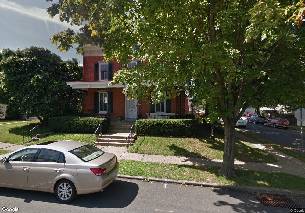
86 N Clinton St Doylestown, PA 18901
Estimated Value: $808,580 - $1,138,000
5
Beds
2
Baths
2,528
Sq Ft
$378/Sq Ft
Est. Value
About This Home
This home is located at 86 N Clinton St, Doylestown, PA 18901 and is currently estimated at $954,395, approximately $377 per square foot. 86 N Clinton St is a home located in Bucks County with nearby schools including Doyle El School, Lenape Middle School, and Central Bucks High School-West.
Ownership History
Date
Name
Owned For
Owner Type
Purchase Details
Closed on
Sep 26, 2016
Sold by
Munoz John C and Munoz Sharlene Marie Jordon
Bought by
Munoz John C and Munoz Sharlene Marie Jordan
Current Estimated Value
Home Financials for this Owner
Home Financials are based on the most recent Mortgage that was taken out on this home.
Original Mortgage
$590,400
Outstanding Balance
$376,055
Interest Rate
3.43%
Mortgage Type
New Conventional
Estimated Equity
$578,340
Purchase Details
Closed on
May 15, 2015
Sold by
Gilhorn John G and Gilhorn Susan R
Bought by
Munzo John C and Munoz Sharlene Marie Jordon
Home Financials for this Owner
Home Financials are based on the most recent Mortgage that was taken out on this home.
Original Mortgage
$166,000
Interest Rate
3.69%
Mortgage Type
Stand Alone Second
Purchase Details
Closed on
Dec 16, 1968
Bought by
Gilhorn John G and Gilhorn Susan R
Create a Home Valuation Report for This Property
The Home Valuation Report is an in-depth analysis detailing your home's value as well as a comparison with similar homes in the area
Home Values in the Area
Average Home Value in this Area
Purchase History
| Date | Buyer | Sale Price | Title Company |
|---|---|---|---|
| Munoz John C | -- | Attorney | |
| Munzo John C | $597,500 | None Available | |
| Gilhorn John G | -- | -- |
Source: Public Records
Mortgage History
| Date | Status | Borrower | Loan Amount |
|---|---|---|---|
| Open | Munoz John C | $590,400 | |
| Closed | Munzo John C | $166,000 |
Source: Public Records
Tax History Compared to Growth
Tax History
| Year | Tax Paid | Tax Assessment Tax Assessment Total Assessment is a certain percentage of the fair market value that is determined by local assessors to be the total taxable value of land and additions on the property. | Land | Improvement |
|---|---|---|---|---|
| 2025 | $5,015 | $27,840 | $5,000 | $22,840 |
| 2024 | $5,015 | $27,840 | $5,000 | $22,840 |
| 2023 | $4,778 | $27,840 | $5,000 | $22,840 |
| 2022 | $4,712 | $27,840 | $5,000 | $22,840 |
| 2021 | $4,660 | $27,840 | $5,000 | $22,840 |
| 2020 | $4,609 | $27,840 | $5,000 | $22,840 |
| 2019 | $4,558 | $27,840 | $5,000 | $22,840 |
| 2018 | $4,502 | $27,840 | $5,000 | $22,840 |
| 2017 | $4,455 | $27,840 | $5,000 | $22,840 |
| 2016 | $4,455 | $27,840 | $5,000 | $22,840 |
| 2015 | -- | $27,840 | $5,000 | $22,840 |
| 2014 | -- | $27,840 | $5,000 | $22,840 |
Source: Public Records
Map
Nearby Homes
- 37 N Clinton St
- 130 N Clinton St
- 123 S Franklin St
- 83 S Hamilton St
- 20 E Court St
- 69 E Oakland Ave
- 195 Lafayette St
- 1 Barnes Ct
- 146 N Church St
- 110 E Ashland St
- 226 N Main St
- 79 Hillside Ave
- 146 E Court St
- 155 E Oakland Ave
- 236 Green St
- 2-3 Aspen Way Unit 23
- 9 Mill Creek Dr
- 89 Homestead Dr
- 403 S Main St Unit C202
- 403 S Main St Unit S201
- 80 N Clinton St
- 74 N Clinton St
- 100 N Clinton St Unit 1
- 100 N Clinton St
- 102 N Clinton St Unit 2
- 102 N Clinton St Unit 3
- 155 Decatur St Unit 3
- 68 N Clinton St
- 160 Decatur St Unit A
- 160 Decatur St
- 104 N Clinton St
- 106 N Clinton St
- 168 Decatur St
- 81 N Clinton St
- 87 N Clinton St
- 64 N Clinton St
- 89 N Clinton St
- 79 N Clinton St
- 165 Decatur St
- 73 N Clinton St