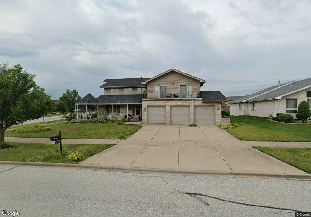
8611 Monaghan Dr Tinley Park, IL 60487
Brookside Glen NeighborhoodEstimated Value: $595,000 - $614,000
4
Beds
4
Baths
3,432
Sq Ft
$176/Sq Ft
Est. Value
About This Home
This home is located at 8611 Monaghan Dr, Tinley Park, IL 60487 and is currently estimated at $603,705, approximately $175 per square foot. 8611 Monaghan Dr is a home located in Will County with nearby schools including Summit Hill Junior High School, Lincoln-Way East High School, and Triple R Child Care.
Ownership History
Date
Name
Owned For
Owner Type
Purchase Details
Closed on
Sep 13, 2006
Sold by
Marquette Bank
Bought by
Eljubeh Rocky
Current Estimated Value
Home Financials for this Owner
Home Financials are based on the most recent Mortgage that was taken out on this home.
Original Mortgage
$370,004
Interest Rate
6.27%
Mortgage Type
New Conventional
Create a Home Valuation Report for This Property
The Home Valuation Report is an in-depth analysis detailing your home's value as well as a comparison with similar homes in the area
Home Values in the Area
Average Home Value in this Area
Purchase History
| Date | Buyer | Sale Price | Title Company |
|---|---|---|---|
| Eljubeh Rocky | $463,000 | Chicago Title Insurance Co |
Source: Public Records
Mortgage History
| Date | Status | Borrower | Loan Amount |
|---|---|---|---|
| Previous Owner | Eljubeh Rocky | $370,004 |
Source: Public Records
Tax History
| Year | Tax Paid | Tax Assessment Tax Assessment Total Assessment is a certain percentage of the fair market value that is determined by local assessors to be the total taxable value of land and additions on the property. | Land | Improvement |
|---|---|---|---|---|
| 2024 | $16,809 | $203,704 | $37,298 | $166,406 |
| 2023 | $16,809 | $181,928 | $33,311 | $148,617 |
| 2022 | $16,194 | $165,706 | $30,341 | $135,365 |
| 2021 | $14,705 | $155,025 | $28,385 | $126,640 |
| 2020 | $14,615 | $150,656 | $27,585 | $123,071 |
| 2019 | $14,240 | $146,624 | $26,847 | $119,777 |
| 2018 | $13,372 | $142,409 | $26,075 | $116,334 |
| 2017 | $13,368 | $139,085 | $25,466 | $113,619 |
| 2016 | $13,222 | $134,317 | $24,593 | $109,724 |
| 2015 | $12,675 | $129,587 | $23,727 | $105,860 |
| 2014 | $12,675 | $128,686 | $23,562 | $105,124 |
| 2013 | $12,675 | $130,355 | $23,868 | $106,487 |
Source: Public Records
Map
Nearby Homes
- 8548 Monaghan Dr
- 8649 Monaghan Dr
- 8607 Glenshire St
- 8543 Brookside Glen Dr
- 19608 Ridgemont Dr
- 19824 Maydell Ct
- 8502 Meadows Edge Trail
- 19518 Ridgemont Dr
- 8614 Bangor Dr Unit 5
- 24455 S 88th Ave
- 19731 Edgebrook Ln
- 19503 Tramore Ln
- 19503 Waterford Ln
- 19501 Waterford Ln
- 19506 Waterford Ln
- 19507 Foxford Ln
- 8803 Willow Ln Unit MODEL
- 19505 Foxford Ln
- 19503 Foxford Ln
- 20151 S Rosewood Dr
- 8619 Monaghan Dr
- 19814 Silverside Dr
- 8612 Monaghan Dr
- 19817 Tulla Ct
- 8555 Monaghan Dr
- 19822 Silverside Dr
- 8622 Monaghan Dr
- 8616 Monaghan Dr
- 8627 Monaghan Dr
- 19821 Tulla Ct
- 8556 Monaghan Dr
- 19812 Tulla Ct
- 8637 Monaghan Dr
- 19815 Silverside Dr
- 8543 Monaghan Dr
- 19828 Silverside Dr
- 8632 Monaghan Dr
- 19736 Silverside Dr
- 19827 Tulla Ct
- 19819 Silverside Dr
Your Personal Tour Guide
Ask me questions while you tour the home.