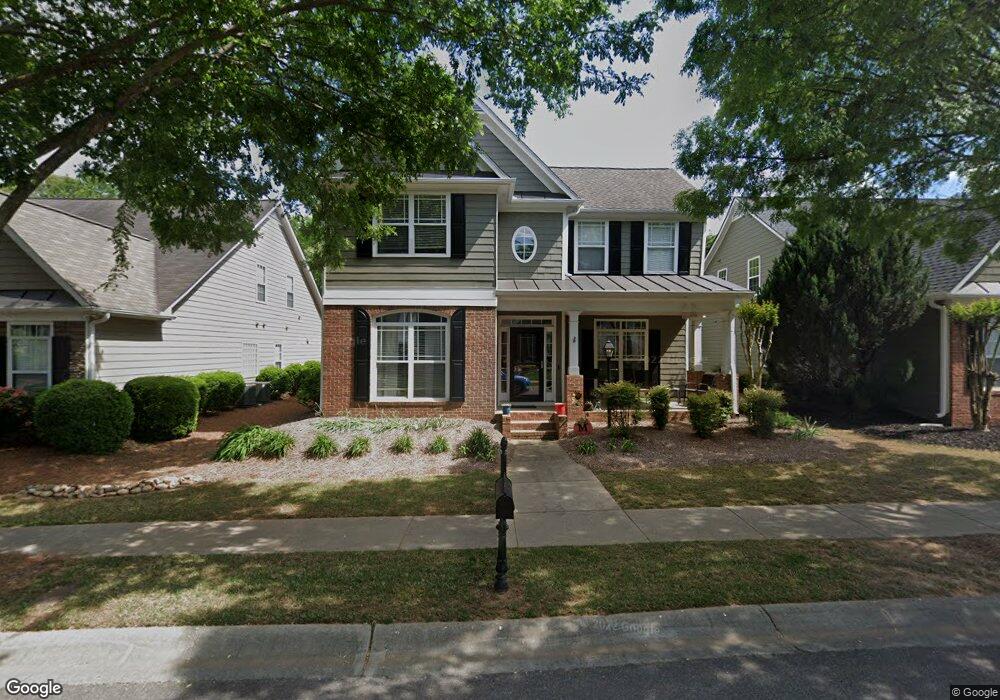
862 Cambron Commons Trace Unit 2 Suwanee, GA 30024
Estimated Value: $510,000 - $523,000
4
Beds
3
Baths
2,300
Sq Ft
$225/Sq Ft
Est. Value
About This Home
This home is located at 862 Cambron Commons Trace Unit 2, Suwanee, GA 30024 and is currently estimated at $517,365, approximately $224 per square foot. 862 Cambron Commons Trace Unit 2 is a home located in Gwinnett County with nearby schools including Roberts Elementary School, North Gwinnett Middle School, and North Gwinnett High School.
Ownership History
Date
Name
Owned For
Owner Type
Purchase Details
Closed on
Jul 25, 2003
Sold by
Richport Properties Inc
Bought by
Mulcahy Deborah J
Current Estimated Value
Home Financials for this Owner
Home Financials are based on the most recent Mortgage that was taken out on this home.
Original Mortgage
$145,650
Interest Rate
6.13%
Mortgage Type
New Conventional
Purchase Details
Closed on
May 5, 1997
Sold by
Cole Betty K
Bought by
Cole Ronnie D
Home Financials for this Owner
Home Financials are based on the most recent Mortgage that was taken out on this home.
Original Mortgage
$90,000
Interest Rate
7.98%
Mortgage Type
New Conventional
Create a Home Valuation Report for This Property
The Home Valuation Report is an in-depth analysis detailing your home's value as well as a comparison with similar homes in the area
Home Values in the Area
Average Home Value in this Area
Purchase History
| Date | Buyer | Sale Price | Title Company |
|---|---|---|---|
| Mulcahy Deborah J | $205,200 | -- | |
| Cole Ronnie D | $25,000 | -- |
Source: Public Records
Mortgage History
| Date | Status | Borrower | Loan Amount |
|---|---|---|---|
| Previous Owner | Mulcahy Deborah J | $145,650 | |
| Previous Owner | Cole Ronnie D | $90,000 |
Source: Public Records
Tax History
| Year | Tax Paid | Tax Assessment Tax Assessment Total Assessment is a certain percentage of the fair market value that is determined by local assessors to be the total taxable value of land and additions on the property. | Land | Improvement |
|---|---|---|---|---|
| 2025 | $4,996 | $214,960 | $44,080 | $170,880 |
| 2024 | $5,047 | $209,720 | $40,800 | $168,920 |
| 2023 | $5,047 | $180,840 | $35,600 | $145,240 |
| 2022 | $5,285 | $174,320 | $35,600 | $138,720 |
| 2021 | $4,228 | $132,920 | $26,800 | $106,120 |
| 2020 | $4,078 | $126,000 | $23,080 | $102,920 |
| 2019 | $3,450 | $126,000 | $23,080 | $102,920 |
| 2018 | $3,385 | $122,160 | $23,080 | $99,080 |
| 2016 | $2,843 | $97,160 | $24,000 | $73,160 |
| 2015 | $2,686 | $88,480 | $18,400 | $70,080 |
| 2014 | -- | $88,480 | $18,400 | $70,080 |
Source: Public Records
Map
Nearby Homes
- 812 Cambron Commons Trace Unit 2
- 821 Scales Rd
- 255 Sims Park Place
- 923 Echo Park Dr
- 3820 White St
- 3655 Belle Fields Crossing
- 3615 Belle Fields Crossing
- 3625 Belle Fields Crossing
- 3675 Belle Fields Crossing
- 3645 Belle Fields Crossing
- 3635 Belle Fields Crossing
- 3685 Belle Fields Crossing
- 714 Urban Grange Way
- 765 Green Sapling Trail
- 3880 Prairie Field Crossing
- 825 Green Sapling Trail Unit 18
- 704 Urban Grange Way
- 3405 Crop Corner Rd
- 722 Urban Grange Way
- 3761 Lake Point Blvd
- 852 Cambron Commons Trace
- 872 Cambron Commons Trace
- N Cambron Commons Trace
- 842 Cambron Commons Trace Unit 2
- 842 Cambron Commons Trace
- 882 Cambron Commons Trace
- 863 Cambron Commons Trace
- 853 Cambron Commons Trace
- 873 Cambron Commons Trace Unit 2
- 832 Cambron Commons Trace Unit 2
- 892 Cambron Commons Trace
- 883 Cambron Commons Trace Unit 2
- 843 Cambron Commons Trace Unit 2
- 822 Cambron Commons Trace
- 902 Cambron Commons Trace Unit 2
- 893 Cambron Commons Trace Unit 2
- 903 Cambron Commons Trace
- 866 Scales Rd NW Unit 866
- 912 Cambron Commons Trace
- 870 Scales Rd
Your Personal Tour Guide
Ask me questions while you tour the home.