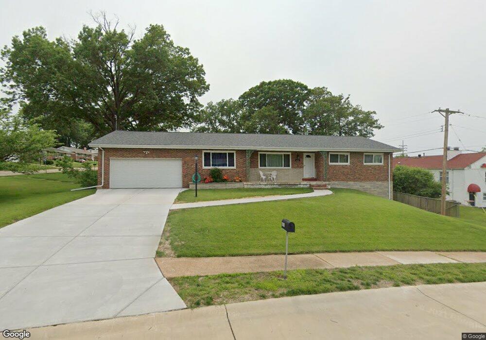
8621 Brookview Dr Saint Louis, MO 63126
Estimated Value: $342,000 - $428,000
3
Beds
2
Baths
1,750
Sq Ft
$217/Sq Ft
Est. Value
About This Home
This home is located at 8621 Brookview Dr, Saint Louis, MO 63126 and is currently estimated at $379,182, approximately $216 per square foot. 8621 Brookview Dr is a home located in St. Louis County with nearby schools including Long Elementary, Truman Middle School, and Lindbergh High School.
Ownership History
Date
Name
Owned For
Owner Type
Purchase Details
Closed on
Oct 8, 1998
Sold by
Clatto Peter G
Bought by
Fink Michael R and Fink Mary A
Current Estimated Value
Home Financials for this Owner
Home Financials are based on the most recent Mortgage that was taken out on this home.
Original Mortgage
$115,360
Outstanding Balance
$22,598
Interest Rate
6.81%
Mortgage Type
VA
Estimated Equity
$356,584
Create a Home Valuation Report for This Property
The Home Valuation Report is an in-depth analysis detailing your home's value as well as a comparison with similar homes in the area
Home Values in the Area
Average Home Value in this Area
Purchase History
| Date | Buyer | Sale Price | Title Company |
|---|---|---|---|
| Fink Michael R | -- | -- |
Source: Public Records
Mortgage History
| Date | Status | Borrower | Loan Amount |
|---|---|---|---|
| Open | Fink Michael R | $115,360 |
Source: Public Records
Tax History
| Year | Tax Paid | Tax Assessment Tax Assessment Total Assessment is a certain percentage of the fair market value that is determined by local assessors to be the total taxable value of land and additions on the property. | Land | Improvement |
|---|---|---|---|---|
| 2025 | $4,136 | $60,800 | $22,210 | $38,590 |
| 2024 | $4,136 | $59,560 | $22,210 | $37,350 |
| 2023 | $4,136 | $59,560 | $22,210 | $37,350 |
| 2022 | $3,748 | $52,020 | $22,210 | $29,810 |
| 2021 | $3,416 | $52,020 | $22,210 | $29,810 |
| 2020 | $3,221 | $47,290 | $16,660 | $30,630 |
| 2019 | $3,212 | $47,290 | $16,660 | $30,630 |
| 2018 | $2,804 | $37,370 | $9,040 | $28,330 |
| 2017 | $2,774 | $37,370 | $9,040 | $28,330 |
| 2016 | $2,246 | $30,590 | $8,090 | $22,500 |
| 2015 | $2,259 | $30,590 | $8,090 | $22,500 |
| 2014 | $2,392 | $32,080 | $8,060 | $24,020 |
Source: Public Records
Map
Nearby Homes
- 1666 Crabapple Ln
- 9412 Lodge Pole Ln
- 1024 Woodbine Dr
- 689 Conover Ln
- 51 Blackthorn Dr
- 614 Conover Ln
- 8563 Old Sappington Rd
- 7919 Royal Arms Ct Unit 2
- 450 Forest Green Dr
- 7929 S Rock Hill Rd
- 1048 Diversey Dr
- 1412 Gardenia Dr
- 904 Liggett Ave
- 7927 S Rock Hill Rd
- 7925 S Rock Hill Rd
- 9 Holly Dr
- 9149 Garber Rd
- 1323 Samoa Dr
- 1139 Hawken Place Unit 6
- 7654 Paragon Cir
- 9217 Lurline Dr
- 9221 Lurline Dr
- 9120 Watson Rd
- 9120 Watson Rd Unit BOTTOM
- 9214 Lurline Dr
- 8622 Brookview Dr
- 8701 Brookview Dr
- 8618 Brookview Dr
- 9225 Lurline Dr
- 9218 Lurline Dr
- 8630 Brookview Dr
- 8700 Brookview Dr
- 9222 Lurline Dr
- 9229 Lurline Dr
- 9211 Silvercrest Dr
- 8704 Brookview Dr
- 9215 Silvercrest Dr
- 9226 Lurline Dr
- 8707 Brookview Dr
- 9219 Silvercrest Dr
Your Personal Tour Guide
Ask me questions while you tour the home.