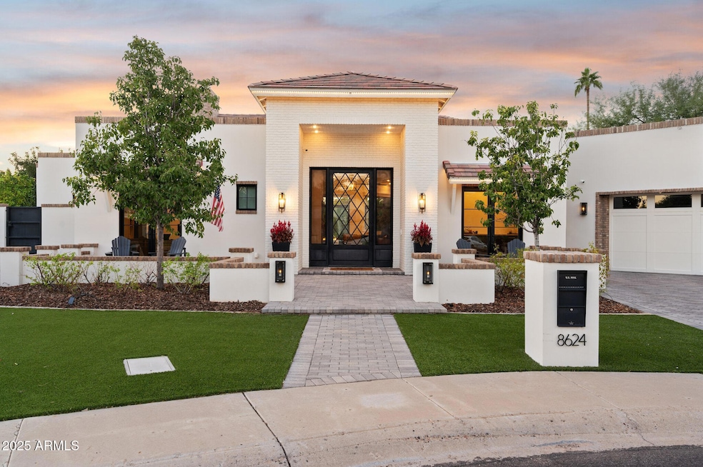
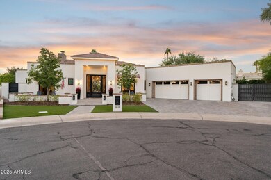
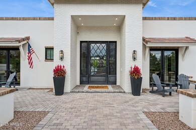
8624 E Carol Way Scottsdale, AZ 85260
Estimated payment $19,136/month
Highlights
- Tennis Courts
- Heated Spa
- Solar Power System
- Sonoran Sky Elementary School Rated A
- RV Gated
- Two Primary Bathrooms
About This Home
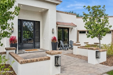
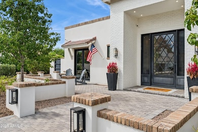
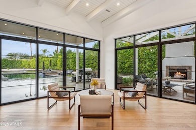
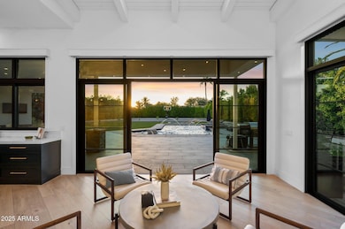
Ultimate Luxury, Intuitive Design, and Resort-Style Living. Welcome to the Premiere Greenstone Estate. Rebuilt in 2020, this 4-bed, 5-bath home offers 4,400 square feet of refined living, blending thoughtful design with high-performance systems and complete privacy. Gorgeous hardwood floors run throughout, complemented by soaring ceilings and an abundance of natural light pouring in through oversized windows. The open layout is anchored by a kitchen that is as beautiful as it is functional... featuring a full Miele appliance package, double dishwashers and sinks, and a butler's pantry designed for effortless entertaining. Step outside to a backyard built for both relaxation and play, featuring a 35' x 60' concrete sport court *that the sellers will have painted with the lines and colors of your choice with an acceptable offer.* A custom Pebble-Tec pool includes laminar jets, in-floor cleaning, RGB lighting, and a propane heater. Add in a high-pressure misting system, outdoor fireplace, built-in seating area, and over 300 mature sour orange hedges, and you've created a private resort-style experience with your own home. To top it all off, electrical conduit and plumbing have already been pre-run to the backyard, making it easy to add a pool house or ADU if you are so inclined. Back inside, go unwind in your infrared sauna or steam shower in the primary suite, while guests enjoy en-suite bathrooms in three of the four bedrooms. The home is fully encapsulated with spray foam insulation, including interior walls, for enhanced energy efficiency and soundproofing. Tucked just minutes from the 101, the Greenstone Estate offers quick and convenient access to all that Scottsdale has to offer. Fully rebuilt, meticulously upgraded, and designed to impress... come experience true luxury living.
Home Details
Home Type
- Single Family
Est. Annual Taxes
- $6,412
Year Built
- Built in 1993
Lot Details
- 0.52 Acre Lot
- Cul-De-Sac
- Block Wall Fence
- Artificial Turf
- Misting System
- Front and Back Yard Sprinklers
HOA Fees
- $155 Monthly HOA Fees
Parking
- 3 Car Garage
- 1 Open Parking Space
- Garage Door Opener
- RV Gated
Home Design
- Contemporary Architecture
- Wood Frame Construction
- Tile Roof
- Stucco
Interior Spaces
- 4,398 Sq Ft Home
- 1-Story Property
- Vaulted Ceiling
- Ceiling Fan
- Skylights
- Gas Fireplace
- Double Pane Windows
- Mechanical Sun Shade
- Family Room with Fireplace
- 3 Fireplaces
- Living Room with Fireplace
- Security System Owned
Kitchen
- Eat-In Kitchen
- Breakfast Bar
- Built-In Gas Oven
- Gas Cooktop
- Built-In Microwave
- Kitchen Island
Flooring
- Wood
- Tile
Bedrooms and Bathrooms
- 4 Bedrooms
- Fireplace in Primary Bedroom
- Remodeled Bathroom
- Two Primary Bathrooms
- Primary Bathroom is a Full Bathroom
- 4 Bathrooms
- Dual Vanity Sinks in Primary Bathroom
- Bathtub With Separate Shower Stall
- Steam Shower
- Solar Tube
Pool
- Heated Spa
- Heated Pool
Outdoor Features
- Tennis Courts
- Covered Patio or Porch
- Outdoor Fireplace
Schools
- Sonoran Sky Elementary School
- Desert Shadows Elementary Middle School
- Horizon High School
Utilities
- Central Air
- Heating System Uses Propane
- Propane
- Tankless Water Heater
- High Speed Internet
Additional Features
- No Interior Steps
- Solar Power System
Listing and Financial Details
- Tax Lot 37
- Assessor Parcel Number 175-12-193
Community Details
Overview
- Association fees include ground maintenance
- Greenstone HOA, Phone Number (623) 572-7579
- Built by Custom
- Greenstone Replat Lot 1 50 Tr A D Subdivision
Recreation
- Pickleball Courts
- Sport Court
- Handball Court
Map
Home Values in the Area
Average Home Value in this Area
Tax History
| Year | Tax Paid | Tax Assessment Tax Assessment Total Assessment is a certain percentage of the fair market value that is determined by local assessors to be the total taxable value of land and additions on the property. | Land | Improvement |
|---|---|---|---|---|
| 2025 | $6,520 | $78,301 | -- | -- |
| 2024 | $6,293 | $74,572 | -- | -- |
| 2023 | $6,293 | $129,360 | $25,870 | $103,490 |
| 2022 | $6,195 | $102,360 | $20,470 | $81,890 |
| 2021 | $6,312 | $93,360 | $18,670 | $74,690 |
| 2020 | $6,296 | $70,170 | $14,030 | $56,140 |
| 2019 | $6,352 | $67,210 | $13,440 | $53,770 |
| 2018 | $6,163 | $63,100 | $12,620 | $50,480 |
| 2017 | $5,867 | $62,080 | $12,410 | $49,670 |
| 2016 | $5,800 | $59,060 | $11,810 | $47,250 |
| 2015 | $5,499 | $55,350 | $11,070 | $44,280 |
Property History
| Date | Event | Price | List to Sale | Price per Sq Ft |
|---|---|---|---|---|
| 10/25/2025 10/25/25 | Pending | -- | -- | -- |
| 10/16/2025 10/16/25 | For Sale | $3,500,000 | -- | $796 / Sq Ft |
Purchase History
| Date | Type | Sale Price | Title Company |
|---|---|---|---|
| Interfamily Deed Transfer | $686,000 | None Available | |
| Cash Sale Deed | $675,000 | Stewart Title & Trust Of Pho | |
| Warranty Deed | $970,000 | Capital Title Agency Inc |
Mortgage History
| Date | Status | Loan Amount | Loan Type |
|---|---|---|---|
| Closed | $335,000 | Seller Take Back | |
| Previous Owner | $727,500 | New Conventional |
Source: Arizona Regional Multiple Listing Service (ARMLS)
MLS Number: 6933992
APN: 175-12-193
Disclaimer: Certain information contained herein is derived from information provided by parties other than Homes.com. All information provided is deemed reliable, but is not guaranteed to be accurate and should be independently verified.
![]() All information should be verified by the recipient and none is guaranteed as accurate by ARMLS
All information should be verified by the recipient and none is guaranteed as accurate by ARMLS
Listing Information presented by local MLS brokerage: Ten-X, local REALTOR®- Arlene Richardson - (888)-952-6393
- 8655 E Charter Oak Dr
- 12475 N 85th St
- 8476 E Wethersfield Rd
- 8853 E Charter Oak Dr
- 12633 N 88th Place
- 8685 E Aster Dr
- 8417 E Cactus Rd
- 8804 E Sunnyside Dr
- 8926 E Ann Way
- 8832 E Sunnyside Dr
- 11612 N 86th St
- 8906 E Windrose Dr
- 8938 E Dahlia Dr
- 8819 E Altadena Ave
- 11828 N 90th Place
- 11945 N 83rd Place
- 11905 N 83rd Place
- 8837 E Cortez St
- 8894 E Wood Dr
- 9015 E Altadena Ave
