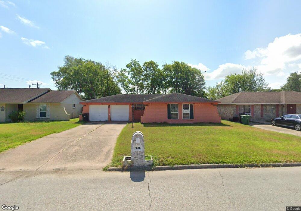
8626 Damascus Dr Houston, TX 77088
Acres Homes NeighborhoodEstimated Value: $165,000 - $208,000
3
Beds
2
Baths
1,547
Sq Ft
$125/Sq Ft
Est. Value
About This Home
This home is located at 8626 Damascus Dr, Houston, TX 77088 and is currently estimated at $193,626, approximately $125 per square foot. 8626 Damascus Dr is a home located in Harris County with nearby schools including Osborne Elementary School, Williams Middle, and Booker T Washington Sr High.
Ownership History
Date
Name
Owned For
Owner Type
Purchase Details
Closed on
Jul 21, 1997
Sold by
Hud
Bought by
Bercian Juan
Current Estimated Value
Home Financials for this Owner
Home Financials are based on the most recent Mortgage that was taken out on this home.
Original Mortgage
$33,077
Outstanding Balance
$4,782
Interest Rate
7.6%
Mortgage Type
FHA
Estimated Equity
$188,844
Purchase Details
Closed on
Aug 6, 1996
Sold by
Source One Mtg Services Corp
Bought by
Hud
Create a Home Valuation Report for This Property
The Home Valuation Report is an in-depth analysis detailing your home's value as well as a comparison with similar homes in the area
Home Values in the Area
Average Home Value in this Area
Purchase History
| Date | Buyer | Sale Price | Title Company |
|---|---|---|---|
| Bercian Juan | $33,000 | American Title Co | |
| Hud | -- | -- | |
| Source One Mtg Services Corp | $42,278 | -- |
Source: Public Records
Mortgage History
| Date | Status | Borrower | Loan Amount |
|---|---|---|---|
| Open | Bercian Juan | $33,077 |
Source: Public Records
Tax History Compared to Growth
Tax History
| Year | Tax Paid | Tax Assessment Tax Assessment Total Assessment is a certain percentage of the fair market value that is determined by local assessors to be the total taxable value of land and additions on the property. | Land | Improvement |
|---|---|---|---|---|
| 2025 | $3,254 | $168,898 | $77,712 | $91,186 |
| 2024 | $3,254 | $155,502 | $77,712 | $77,790 |
| 2023 | $3,254 | $155,506 | $77,712 | $77,794 |
| 2022 | $3,136 | $142,403 | $53,427 | $88,976 |
| 2021 | $2,593 | $111,239 | $32,380 | $78,859 |
| 2020 | $2,584 | $106,701 | $25,904 | $80,797 |
| 2019 | $2,359 | $93,229 | $25,904 | $67,325 |
| 2018 | $1,899 | $75,047 | $14,571 | $60,476 |
| 2017 | $1,898 | $75,047 | $14,571 | $60,476 |
| 2016 | $1,898 | $75,047 | $14,571 | $60,476 |
| 2015 | $1,455 | $69,018 | $14,571 | $54,447 |
| 2014 | $1,455 | $56,604 | $14,571 | $42,033 |
Source: Public Records
Map
Nearby Homes
- 8615 Citation Ct
- 1559 Diplomat Way
- 1314 Tarberry Rd
- 8718 Glen Shadow Dr
- 1054 Dewalt St
- 0 Grenshaw
- 1707 Winter Bay Ln
- 9208 Ab Wheatley St
- 9206 Ab Wheatley St
- 9010 Wheatley St
- 954 W Bertrand St
- 1028 Marcolin St
- 1030 Marcolin St
- 0 Marcolin St
- 1032 Marcolin St
- 1034 Marcolin St
- 1826 Dewalt St
- 1307 Saddle Rock Dr
- 2018 Dewalt St
- 958 Conklin St
- 8622 Damascus Dr
- 8630 Damascus Dr
- 8615 Iron Liege Ct
- 8611 Iron Liege Ct
- 8618 Damascus Dr
- 8619 Iron Liege Ct
- 8627 Damascus Dr
- 8607 Iron Liege Ct
- 8631 Damascus Dr
- 8623 Damascus Dr
- 8614 Damascus Dr
- 8619 Damascus Dr
- 8603 Iron Liege Ct
- 8618 Iron Liege Ct
- 8615 Damascus Dr
- 8614 Sunmoore Ct
- 8610 Sunmoore Ct
- 8610 Iron Liege Ct
- 8606 Sunmoore Ct
- 8614 Iron Liege Ct