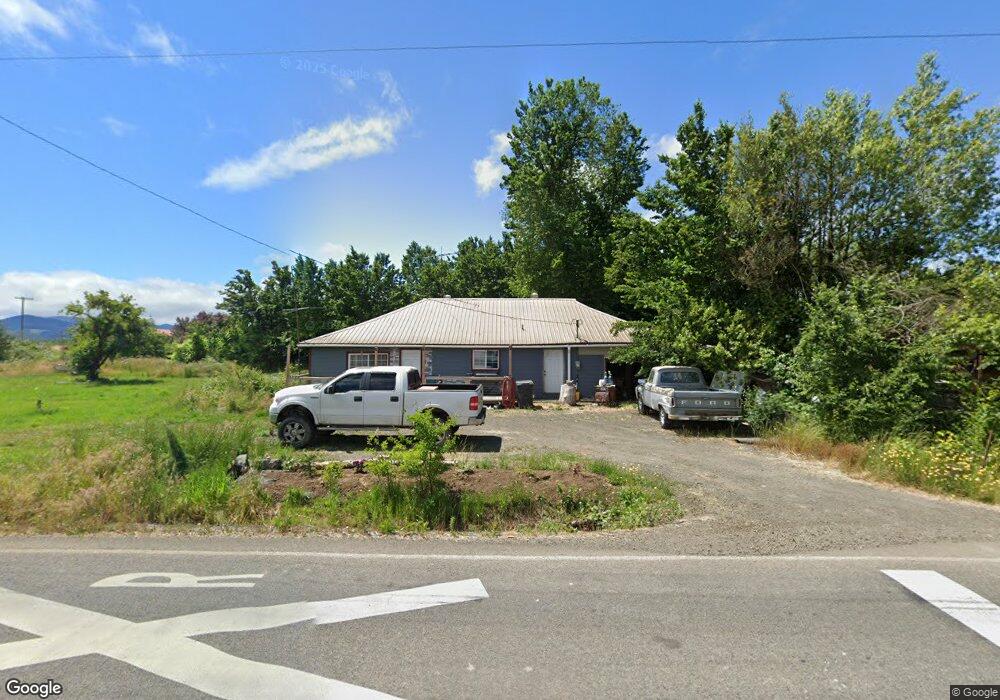
8630 Suver Rd Monmouth, OR 97361
Estimated Value: $261,000 - $305,000
2
Beds
1
Bath
1,140
Sq Ft
$254/Sq Ft
Est. Value
About This Home
This home is located at 8630 Suver Rd, Monmouth, OR 97361 and is currently estimated at $289,781, approximately $254 per square foot. 8630 Suver Rd is a home located in Polk County with nearby schools including Monmouth Elementary School, Talmadge Middle School, and Central High School.
Ownership History
Date
Name
Owned For
Owner Type
Purchase Details
Closed on
Jan 11, 2024
Sold by
Brown Michael R
Bought by
Adds Keasha K and Morford Patrick E
Current Estimated Value
Home Financials for this Owner
Home Financials are based on the most recent Mortgage that was taken out on this home.
Original Mortgage
$85,000
Outstanding Balance
$79,046
Interest Rate
6.38%
Mortgage Type
New Conventional
Estimated Equity
$210,735
Create a Home Valuation Report for This Property
The Home Valuation Report is an in-depth analysis detailing your home's value as well as a comparison with similar homes in the area
Home Values in the Area
Average Home Value in this Area
Purchase History
| Date | Buyer | Sale Price | Title Company |
|---|---|---|---|
| Adds Keasha K | $110,000 | Amerititle |
Source: Public Records
Mortgage History
| Date | Status | Borrower | Loan Amount |
|---|---|---|---|
| Open | Adds Keasha K | $85,000 |
Source: Public Records
Tax History Compared to Growth
Tax History
| Year | Tax Paid | Tax Assessment Tax Assessment Total Assessment is a certain percentage of the fair market value that is determined by local assessors to be the total taxable value of land and additions on the property. | Land | Improvement |
|---|---|---|---|---|
| 2025 | $1,854 | $148,620 | $78,500 | $70,120 |
| 2024 | $1,854 | $144,300 | $76,220 | $68,080 |
| 2023 | $1,973 | $140,100 | $74,000 | $66,100 |
| 2022 | $1,733 | $136,020 | $71,850 | $64,170 |
| 2021 | $1,720 | $132,060 | $69,760 | $62,300 |
| 2020 | $1,671 | $128,220 | $67,740 | $60,480 |
| 2019 | $1,622 | $124,490 | $65,770 | $58,720 |
| 2018 | $1,563 | $120,870 | $63,860 | $57,010 |
| 2017 | $1,565 | $117,350 | $62,000 | $55,350 |
| 2016 | $1,620 | $113,940 | $60,200 | $53,740 |
| 2015 | $1,540 | $110,630 | $58,450 | $52,180 |
| 2014 | $1,506 | $107,410 | $56,750 | $50,660 |
Source: Public Records
Map
Nearby Homes
- 11515 Buena Vista Rd
- 11500 Church St
- 0 Highway 99w Unit 23169928
- 5970 NW Independence Hwy
- 11660 Simpson Rd
- 0 Unassigned Unit 21274407
- 39027 Trillium Ln
- 8645 Highland Rd
- 11050 Elkins (Next To) Rd
- 1163 SW 11th Ave
- 0 Simpson Rd
- Lot 900 NE Hibiscus Dr
- 4135 NW Alder Ave
- 9603 Rd
- 0 NW Bramblewood Ln
- 10845 Brateng Rd
- 4266 NW Palestine Ave
- 0 Powers (Lot 3) Ave NW Unit 825003
- 3 NW Powers Ave
- 3714 NW Wishram Dr
- 8680 Suver Rd
- 8725 Suver Rd
- 8470 Suver Rd
- 8350 Suver Rd
- 8580 Suver Rd
- 13160 S Pacific Hwy W
- 13030 S Pacific Hwy W
- 13030 S Pacific Hwy W
- 13030 S Pacific Hwy W
- 13000 S Pacific Hwy W
- 13040 S Pacific Hwy W
- 13005 S Pacific Hwy W
- 12680 S Pacific Hwy W
- 13445 S Pacific Hwy W
- 7901 Suver Rd
- 12685 Helmick Rd
- 12600 Helmick Rd
- 13860 S Pacific Hwy W