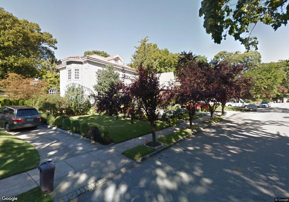
8632 Palo Alto St Hollis, NY 11423
Holliswood NeighborhoodEstimated Value: $1,055,760 - $1,310,000
--
Bed
--
Bath
2,432
Sq Ft
$507/Sq Ft
Est. Value
About This Home
This home is located at 8632 Palo Alto St, Hollis, NY 11423 and is currently estimated at $1,231,940, approximately $506 per square foot. 8632 Palo Alto St is a home located in Queens County with nearby schools including P.S. 35 Nathaniel Woodhull, I.S. 238 Susan B Anthony Academy, and The Wellspring Schools.
Ownership History
Date
Name
Owned For
Owner Type
Purchase Details
Closed on
Apr 8, 2025
Sold by
Shimonov Eric
Bought by
8632 Palo Alto Llc
Current Estimated Value
Purchase Details
Closed on
Jul 22, 2024
Sold by
Bassiri-Tehrani Farhad
Bought by
8632 Palo Alto St Llc
Purchase Details
Closed on
Aug 11, 2003
Sold by
Fbt Homes Management Llc
Bought by
Bassiri-Tehrani Farhad
Purchase Details
Closed on
Mar 24, 2001
Sold by
H A H Associates Inc
Bought by
Fbt Homes Management Llc
Create a Home Valuation Report for This Property
The Home Valuation Report is an in-depth analysis detailing your home's value as well as a comparison with similar homes in the area
Home Values in the Area
Average Home Value in this Area
Purchase History
| Date | Buyer | Sale Price | Title Company |
|---|---|---|---|
| 8632 Palo Alto Llc | -- | -- | |
| 8632 Palo Alto St Llc | $1,032,500 | -- | |
| Bassiri-Tehrani Farhad | -- | -- | |
| Bassiri-Tehrani Farhad | -- | -- | |
| Fbt Homes Management Llc | -- | -- | |
| Fbt Homes Management Llc | -- | -- |
Source: Public Records
Tax History Compared to Growth
Tax History
| Year | Tax Paid | Tax Assessment Tax Assessment Total Assessment is a certain percentage of the fair market value that is determined by local assessors to be the total taxable value of land and additions on the property. | Land | Improvement |
|---|---|---|---|---|
| 2025 | $10,171 | $53,677 | $13,811 | $39,866 |
| 2024 | $10,171 | $50,640 | $13,561 | $37,079 |
| 2023 | $9,595 | $47,774 | $12,416 | $35,358 |
| 2022 | $9,537 | $67,500 | $20,100 | $47,400 |
| 2021 | $9,978 | $57,720 | $20,100 | $37,620 |
| 2020 | $9,468 | $63,420 | $20,100 | $43,320 |
| 2019 | $8,828 | $60,120 | $20,100 | $40,020 |
| 2018 | $8,116 | $39,812 | $12,247 | $27,565 |
| 2017 | $8,116 | $39,812 | $13,665 | $26,147 |
| 2016 | $7,899 | $39,812 | $13,665 | $26,147 |
| 2015 | $4,530 | $37,276 | $18,032 | $19,244 |
| 2014 | $4,530 | $35,167 | $18,662 | $16,505 |
Source: Public Records
Map
Nearby Homes
- 190-22 Nero Ave
- 86-55 Santiago St
- 8714 Santiago St
- 8684 188th St
- 8702 Chevy Chase St
- 8702 188th St
- 8716 Palo Alto St
- 195-12 Mclaughlin Ave
- 186-34 Henley Rd
- 19346 Mclaughlin Ave
- 184-51 Hovenden Rd
- 19127 Foothill Ave
- 193-03 85th Rd
- 19512 Mclaughlin Ave
- 19615 Como Ave
- 195-22 Mclaughlin Ave
- 193-55 85th Rd
- 187-14 Wexford Terrace
- 18414 Grand Central Pkwy
- 8746 Chelsea St Unit 6E
- 86-32 Palo Alto St
- 8628 Palo Alto St
- 8636 Palo Alto St
- 8624 Palo Alto St
- 8646 Palo Alto St
- 8620 Palo Alto St
- 8652 Palo Alto St
- 86-23 Santiago St
- 8609 Santiago St
- 8605 Santiago St
- 86-05 Santiago St
- 8623 Santiago St
- 8601 Santiago St
- 86-01 Santiago St
- 8627 Santiago St
- 8656 Palo Alto St
- 19026 Nero Ave
- 8618 Palo Alto St
- 19022 Nero Ave
- 8633 Palo Alto St