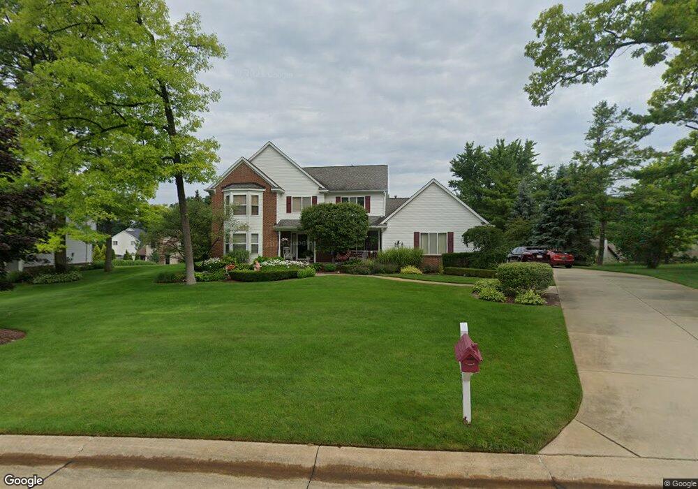
8640 Hancock Dr White Lake, MI 48386
Estimated Value: $495,355 - $528,000
4
Beds
3
Baths
2,723
Sq Ft
$188/Sq Ft
Est. Value
About This Home
This home is located at 8640 Hancock Dr, White Lake, MI 48386 and is currently estimated at $511,339, approximately $187 per square foot. 8640 Hancock Dr is a home located in Oakland County with nearby schools including Clifford H. Smart Middle School, Walled Lake Northern High School, and Lakecrest Baptist School.
Ownership History
Date
Name
Owned For
Owner Type
Purchase Details
Closed on
Jul 1, 2003
Sold by
Clarke David
Bought by
Clarke David and Clarke Elaine L
Current Estimated Value
Purchase Details
Closed on
Jul 31, 1998
Sold by
Kinzly Michael R
Bought by
Clarke David
Home Financials for this Owner
Home Financials are based on the most recent Mortgage that was taken out on this home.
Original Mortgage
$180,000
Outstanding Balance
$38,009
Interest Rate
7.06%
Estimated Equity
$473,330
Purchase Details
Closed on
Nov 3, 1994
Sold by
Welcom Homes Inc
Bought by
Kinzly Michael R and Kinzly A
Home Financials for this Owner
Home Financials are based on the most recent Mortgage that was taken out on this home.
Original Mortgage
$200,000
Interest Rate
8.63%
Create a Home Valuation Report for This Property
The Home Valuation Report is an in-depth analysis detailing your home's value as well as a comparison with similar homes in the area
Home Values in the Area
Average Home Value in this Area
Purchase History
| Date | Buyer | Sale Price | Title Company |
|---|---|---|---|
| Clarke David | -- | Golden Title | |
| Clarke David | $290,000 | -- | |
| Kinzly Michael R | $230,100 | -- |
Source: Public Records
Mortgage History
| Date | Status | Borrower | Loan Amount |
|---|---|---|---|
| Open | Clarke David | $180,000 | |
| Previous Owner | Kinzly Michael R | $200,000 |
Source: Public Records
Tax History Compared to Growth
Tax History
| Year | Tax Paid | Tax Assessment Tax Assessment Total Assessment is a certain percentage of the fair market value that is determined by local assessors to be the total taxable value of land and additions on the property. | Land | Improvement |
|---|---|---|---|---|
| 2024 | $2,850 | $212,700 | $0 | $0 |
| 2023 | $2,687 | $192,600 | $0 | $0 |
| 2022 | $4,357 | $179,130 | $0 | $0 |
| 2021 | $4,248 | $169,530 | $0 | $0 |
| 2020 | $2,656 | $164,620 | $0 | $0 |
| 2019 | $4,154 | $159,620 | $0 | $0 |
| 2018 | $4,129 | $152,300 | $0 | $0 |
| 2017 | $3,996 | $152,300 | $0 | $0 |
| 2016 | $3,995 | $147,820 | $0 | $0 |
| 2015 | -- | $137,830 | $0 | $0 |
| 2014 | -- | $119,660 | $0 | $0 |
| 2011 | -- | $111,470 | $0 | $0 |
Source: Public Records
Map
Nearby Homes
- 8110 High Point Trail
- 8993 Haymarket St
- 785 Akehurst Ln
- 00 Union Lake Rd
- 8341 Sharon Dr
- 700 Ander Ln Unit 88
- 8165 Sequoia Ln Unit 92
- 837 Preserve Ln
- 193 Coppice Way
- 8962 Glasgow Dr
- 8363 Capstone Dr
- 8637 Brazos Ct
- 891 Preserve Ln
- 915 Preserve Ln
- 0000 Williams Lake Rd
- 165 Lisa Ct
- 900 Preserve Ln
- 7971 Turrillium Ln
- 229 Summit Ridge
- 315 Tower Rd
- 8644 Hancock Dr
- 8627 Newport Dr
- 427 Newport Cir
- 8631 Newport Dr
- 434 Newport Cir
- 8619 Newport Dr
- 8637 Newport Dr
- 8641 Hancock Dr
- 8648 Hancock Dr
- 8645 Newport Dr
- 8647 Hancock Dr
- 430 Newport Cir
- 8613 Newport Dr
- 8651 Newport Dr
- 8652 Hancock Dr
- 426 Newport Cir
- 8651 Hancock Dr
- 8632 Newport Dr
- 8636 Newport Dr
- 8624 Newport Dr Unit Bldg-Unit