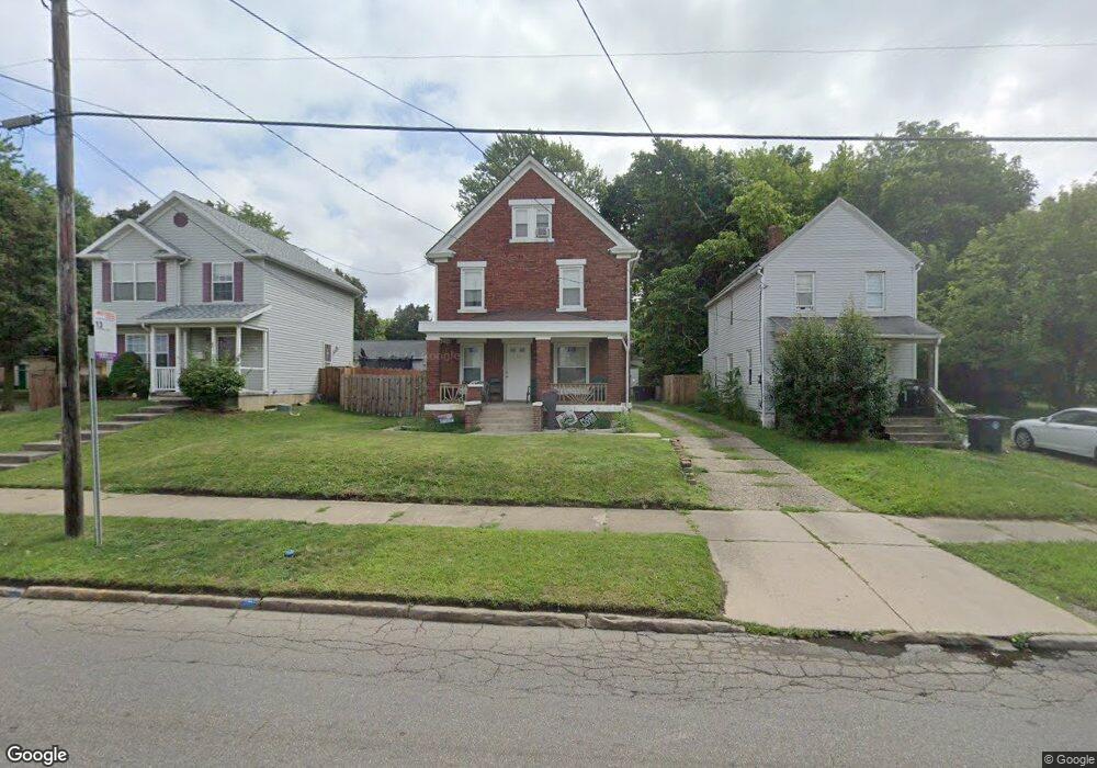
865 Grant St Akron, OH 44311
South Akron NeighborhoodEstimated Value: $61,000 - $79,961
3
Beds
1
Bath
1,613
Sq Ft
$44/Sq Ft
Est. Value
About This Home
This home is located at 865 Grant St, Akron, OH 44311 and is currently estimated at $71,490, approximately $44 per square foot. 865 Grant St is a home located in Summit County with nearby schools including McEbright Elementary School, Kenmore Garfield Community Learning Center, and Main Preparatory Academy.
Ownership History
Date
Name
Owned For
Owner Type
Purchase Details
Closed on
Nov 4, 2019
Sold by
Snider April Lynn and Michaels April Lynn
Bought by
Dees Samuel
Current Estimated Value
Purchase Details
Closed on
Oct 18, 2018
Sold by
Snider Jonathon L
Bought by
Michaels April L
Purchase Details
Closed on
Jul 27, 2016
Sold by
Murdock George S
Bought by
Snider Jonathon L and Snider April L
Purchase Details
Closed on
Jun 13, 1994
Sold by
Shackelford Richard A
Bought by
Murdock George S
Create a Home Valuation Report for This Property
The Home Valuation Report is an in-depth analysis detailing your home's value as well as a comparison with similar homes in the area
Home Values in the Area
Average Home Value in this Area
Purchase History
| Date | Buyer | Sale Price | Title Company |
|---|---|---|---|
| Dees Samuel | $7,000 | None Available | |
| Michaels April L | -- | None Available | |
| Snider Jonathon L | $31,000 | First Security Title | |
| Murdock George S | $16,000 | -- |
Source: Public Records
Tax History Compared to Growth
Tax History
| Year | Tax Paid | Tax Assessment Tax Assessment Total Assessment is a certain percentage of the fair market value that is determined by local assessors to be the total taxable value of land and additions on the property. | Land | Improvement |
|---|---|---|---|---|
| 2025 | $1,127 | $16,587 | $4,417 | $12,170 |
| 2024 | $1,127 | $16,587 | $4,417 | $12,170 |
| 2023 | $1,127 | $16,587 | $4,417 | $12,170 |
| 2022 | $944 | $10,312 | $2,601 | $7,711 |
| 2021 | $945 | $10,312 | $2,601 | $7,711 |
| 2020 | $1,967 | $10,310 | $2,600 | $7,710 |
| 2019 | $809 | $7,850 | $4,840 | $3,010 |
| 2018 | $801 | $7,850 | $4,840 | $3,010 |
| 2017 | $830 | $7,850 | $4,840 | $3,010 |
| 2016 | $830 | $7,900 | $4,840 | $3,060 |
| 2015 | $830 | $7,900 | $4,840 | $3,060 |
| 2014 | $825 | $7,900 | $4,840 | $3,060 |
| 2013 | $821 | $8,010 | $4,840 | $3,170 |
Source: Public Records
Map
Nearby Homes
- 841 Grant St
- 833 Sherman St
- 1148 Marcy St
- 848 Kling St
- 841 Kling St
- 1044 Grant St
- 687 Allyn St
- 668 Sherman St
- 386 E Voris St
- 678 Sumner St Unit 682
- 917 Clay St
- 542 Baird St
- 546 Baird St
- 253,257,261,263 E Thornton St
- 281 E Thornton St
- 656 Kling St Unit 2
- 448 E Voris St
- 628, 634 & 636 Sumner St Unit 6 units
- 685 Brown St
- 294 Sumner Ct