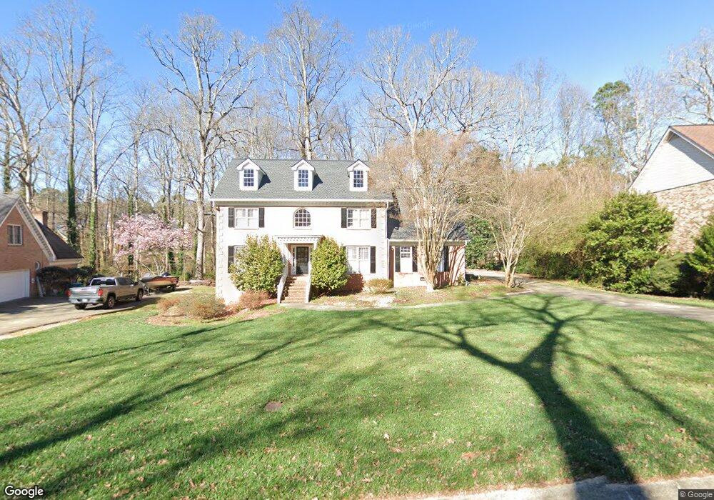
865 Newcastle Dr SW Unit 2 Lilburn, GA 30047
Estimated Value: $555,959 - $603,000
4
Beds
3
Baths
3,208
Sq Ft
$180/Sq Ft
Est. Value
About This Home
This home is located at 865 Newcastle Dr SW Unit 2, Lilburn, GA 30047 and is currently estimated at $577,990, approximately $180 per square foot. 865 Newcastle Dr SW Unit 2 is a home located in Gwinnett County with nearby schools including Camp Creek Elementary School, Trickum Middle School, and Parkview High School.
Ownership History
Date
Name
Owned For
Owner Type
Purchase Details
Closed on
Jul 31, 1998
Sold by
Tester Jack R and Tester Priscilla H
Bought by
Mattox Michael W and Mattox Christine W
Current Estimated Value
Home Financials for this Owner
Home Financials are based on the most recent Mortgage that was taken out on this home.
Original Mortgage
$219,600
Outstanding Balance
$43,626
Interest Rate
6.97%
Mortgage Type
New Conventional
Estimated Equity
$534,364
Create a Home Valuation Report for This Property
The Home Valuation Report is an in-depth analysis detailing your home's value as well as a comparison with similar homes in the area
Home Values in the Area
Average Home Value in this Area
Purchase History
| Date | Buyer | Sale Price | Title Company |
|---|---|---|---|
| Mattox Michael W | $274,500 | -- |
Source: Public Records
Mortgage History
| Date | Status | Borrower | Loan Amount |
|---|---|---|---|
| Open | Mattox Michael W | $219,600 |
Source: Public Records
Tax History Compared to Growth
Tax History
| Year | Tax Paid | Tax Assessment Tax Assessment Total Assessment is a certain percentage of the fair market value that is determined by local assessors to be the total taxable value of land and additions on the property. | Land | Improvement |
|---|---|---|---|---|
| 2025 | $6,565 | $239,200 | $30,000 | $209,200 |
| 2024 | $6,454 | $225,880 | $30,000 | $195,880 |
| 2023 | $6,454 | $170,120 | $29,600 | $140,520 |
| 2022 | $5,276 | $170,120 | $29,600 | $140,520 |
| 2021 | $4,808 | $143,320 | $29,600 | $113,720 |
| 2020 | $4,842 | $143,320 | $29,600 | $113,720 |
| 2019 | $4,444 | $131,640 | $25,600 | $106,040 |
| 2018 | $4,503 | $131,640 | $25,600 | $106,040 |
| 2016 | $4,172 | $115,600 | $20,000 | $95,600 |
| 2015 | $3,920 | $105,040 | $12,000 | $93,040 |
| 2014 | $3,941 | $105,040 | $12,000 | $93,040 |
Source: Public Records
Map
Nearby Homes
- 5033 Charlemagne Way SW
- 5041 Bainbridge Ct SW Unit 3
- 5000 Bainbridge Ct SW
- 5104 Onawa Ct SW
- 888 Castle Walk Cove SW
- 954 Camp Creek Dr SW
- 5002 Abbey Ln SW
- 1054 Morgan Garner Dr SW
- 1075 Westchester Dr SW
- 4872 Arrowhead Trail West SW Unit 1
- 4814 Delgado Dr SW
- 574 Horseshoe Cir SW
- 551 Briggs Cir SW
- 4702 Sequoia Dr SW
- 562 Gregg Dr SW
- 4704 Arrowhead Trail SW
- 881 Rockbridge Rd SW
- 855 Newcastle Dr SW
- 875 Newcastle Dr SW
- 0 Newcastle Dr SW Unit 7504871
- 0 Newcastle Dr SW Unit 7046208
- 0 Newcastle Dr SW Unit 3286124
- 0 Newcastle Dr SW Unit 8491457
- 0 Newcastle Dr SW Unit 7352682
- 0 Newcastle Dr SW Unit 3062940
- 0 Newcastle Dr SW Unit 7386156
- 0 Newcastle Dr SW
- 845 Newcastle Dr SW
- 885 Newcastle Dr SW
- 874 Newcastle Dr SW Unit 2
- 864 Newcastle Dr SW
- 854 Newcastle Dr SW
- 835 Newcastle Dr SW
- 5163 Charlemagne Way SW
- 5173 Charlemagne Way SW
- 894 Newcastle Dr SW
- 895 Newcastle Dr SW