
Seller's Agent in 2026
Michael Gunnarson
Howard Hanna Real Estate Svcs
(614) 403-3163
12 in this area
70 Total Sales
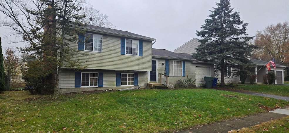
This home is located at 8669 Ripton Dr, Powell, OH 43065 and is currently priced at $190,000, approximately $129 per square foot. This property was built in 1978. 8669 Ripton Dr is a home located in Franklin County with nearby schools including Liberty Elementary School, McCord Middle School, and Worthington Kilbourne High School.
Last Agent to Sell the Property
Howard Hanna Real Estate Svcs License #2004019599 Listed on: 11/21/2025
| Date | Type | Sale Price | Title Company |
|---|---|---|---|
| Warranty Deed | $190,000 | First Ohio Title Insurance Age | |
| Survivorship Deed | $112,900 | Chicago Title West | |
| Deed | $79,500 | -- |
| Date | Status | Loan Amount | Loan Type |
|---|---|---|---|
| Previous Owner | $101,600 | No Value Available |
| Date | Event | Price | List to Sale | Price per Sq Ft |
|---|---|---|---|---|
| 01/16/2026 01/16/26 | Sold | $190,000 | 0.0% | $129 / Sq Ft |
| 11/21/2025 11/21/25 | Pending | -- | -- | -- |
| 11/21/2025 11/21/25 | For Sale | $190,000 | -- | $129 / Sq Ft |
| Year | Tax Paid | Tax Assessment Tax Assessment Total Assessment is a certain percentage of the fair market value that is determined by local assessors to be the total taxable value of land and additions on the property. | Land | Improvement |
|---|---|---|---|---|
| 2025 | $5,737 | $85,510 | $40,740 | $44,770 |
| 2024 | $5,737 | $85,510 | $40,740 | $44,770 |
| 2023 | $5,020 | $85,505 | $40,740 | $44,765 |
| 2022 | $6,067 | $65,490 | $18,450 | $47,040 |
| 2021 | $4,470 | $65,490 | $18,450 | $47,040 |
| 2020 | $4,306 | $65,490 | $18,450 | $47,040 |
| 2019 | $4,027 | $55,270 | $15,370 | $39,900 |
| 2018 | $3,605 | $55,270 | $15,370 | $39,900 |
| 2017 | $3,609 | $55,270 | $15,370 | $39,900 |
| 2016 | $3,308 | $46,590 | $13,200 | $33,390 |
| 2015 | $3,308 | $46,590 | $13,200 | $33,390 |
| 2014 | $3,307 | $46,590 | $13,200 | $33,390 |
| 2013 | $1,645 | $46,585 | $13,195 | $33,390 |
Seller's Agent in 2026
Michael Gunnarson
Howard Hanna Real Estate Svcs
(614) 403-3163
12 in this area
70 Total Sales
A
Buyer's Agent in 2026
Alexander Soskin
Soskin Realty, LLC
(614) 989-8638
3 in this area
288 Total Sales
Source: Columbus and Central Ohio Regional MLS
MLS Number: 225043755
APN: 610-171730
Disclaimer: Certain information contained herein is derived from information provided by parties other than Homes.com. All information provided is deemed reliable, but is not guaranteed to be accurate and should be independently verified.
![]() IDX information is provided exclusively for personal, non-commercial use, and may not be used for any purpose other than to identify prospective properties consumers may be interested in purchasing.
IDX information is provided exclusively for personal, non-commercial use, and may not be used for any purpose other than to identify prospective properties consumers may be interested in purchasing.
Information is deemed reliable but not guaranteed.
Ask me questions while you tour the home.