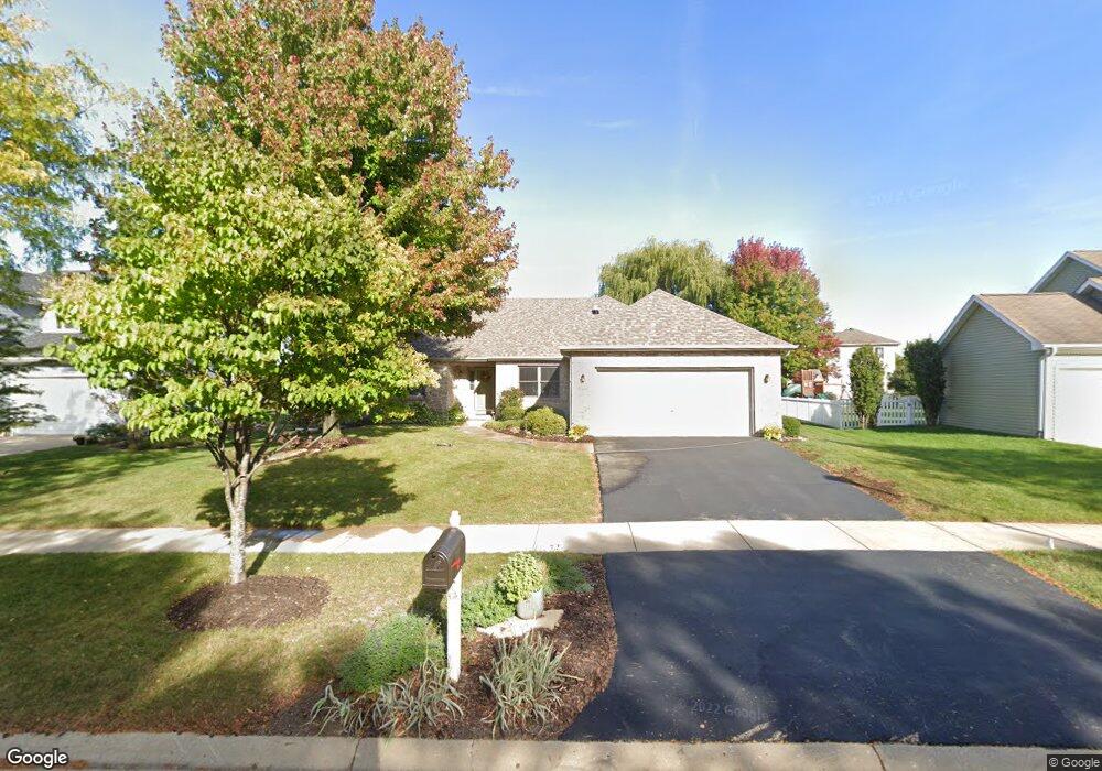
869 Conley Dr Elburn, IL 60119
Estimated Value: $397,000 - $426,000
3
Beds
2
Baths
1,760
Sq Ft
$231/Sq Ft
Est. Value
About This Home
This home is located at 869 Conley Dr, Elburn, IL 60119 and is currently estimated at $406,423, approximately $230 per square foot. 869 Conley Dr is a home located in Kane County with nearby schools including Kaneland John Stewart Elementary School, Harter Middle School, and Kaneland High School.
Ownership History
Date
Name
Owned For
Owner Type
Purchase Details
Closed on
May 25, 2007
Sold by
Dinardo Frank C and Dinardo Surette N
Bought by
Troogstad Edward A and Troogstad Rita L
Current Estimated Value
Home Financials for this Owner
Home Financials are based on the most recent Mortgage that was taken out on this home.
Original Mortgage
$80,000
Outstanding Balance
$48,900
Interest Rate
6.26%
Mortgage Type
Purchase Money Mortgage
Estimated Equity
$357,523
Purchase Details
Closed on
Oct 22, 2006
Sold by
Dinardo Frank C
Bought by
Dinardo Surette N and Dinardo Frank C
Purchase Details
Closed on
Nov 21, 2000
Sold by
Dinardo Tracy and Dinardo Frank
Bought by
Dinardo Frank C
Home Financials for this Owner
Home Financials are based on the most recent Mortgage that was taken out on this home.
Original Mortgage
$144,000
Interest Rate
7.87%
Purchase Details
Closed on
Nov 3, 1999
Sold by
Old Oak Homes Inc
Bought by
Dinardo Frank and Dinardo Tracy
Home Financials for this Owner
Home Financials are based on the most recent Mortgage that was taken out on this home.
Original Mortgage
$75,000
Interest Rate
7.9%
Create a Home Valuation Report for This Property
The Home Valuation Report is an in-depth analysis detailing your home's value as well as a comparison with similar homes in the area
Home Values in the Area
Average Home Value in this Area
Purchase History
| Date | Buyer | Sale Price | Title Company |
|---|---|---|---|
| Troogstad Edward A | $323,000 | Multiple | |
| Dinardo Surette N | -- | None Available | |
| Dinardo Frank C | -- | Chicago Title Insurance Co | |
| Dinardo Frank | $199,000 | Chicago Title Insurance Co |
Source: Public Records
Mortgage History
| Date | Status | Borrower | Loan Amount |
|---|---|---|---|
| Open | Troogstad Edward A | $80,000 | |
| Previous Owner | Dinardo Frank C | $144,000 | |
| Previous Owner | Dinardo Frank | $75,000 |
Source: Public Records
Tax History
| Year | Tax Paid | Tax Assessment Tax Assessment Total Assessment is a certain percentage of the fair market value that is determined by local assessors to be the total taxable value of land and additions on the property. | Land | Improvement |
|---|---|---|---|---|
| 2024 | $8,435 | $112,104 | $20,651 | $91,453 |
| 2023 | $8,120 | $100,227 | $18,463 | $81,764 |
| 2022 | $7,318 | $91,323 | $16,823 | $74,500 |
| 2021 | $7,463 | $86,227 | $15,884 | $70,343 |
| 2020 | $7,522 | $84,986 | $15,655 | $69,331 |
| 2019 | $7,637 | $83,738 | $15,425 | $68,313 |
| 2018 | $7,757 | $83,738 | $15,425 | $68,313 |
| 2017 | $8,053 | $82,509 | $15,199 | $67,310 |
| 2016 | $8,051 | $80,426 | $14,815 | $65,611 |
| 2015 | -- | $78,205 | $14,406 | $63,799 |
| 2014 | -- | $79,404 | $14,627 | $64,777 |
| 2013 | -- | $79,019 | $14,872 | $64,147 |
Source: Public Records
Map
Nearby Homes
- 608 Hoyt Dr
- 644 Houtz Cir
- 801 N 1st St
- The Ontario Plan at Williams Ridge
- Lot 77 Houtz Cir
- 526 N Main St
- 1457 Collins St
- 410 W Reader St
- 803 Station Blvd
- 816 Simpson Ave
- 607 Virginia St
- 42W613 Meadowsweet Dr
- 645 Virginia St
- 671 Virginia St
- 000 Illinois 47
- 1053 Sears Cir
- 1074 Freedom Rd
- 1076 Freedom Rd
- 1164 Freedom Rd
- 43W140 Campton Hills Rd Unit 2