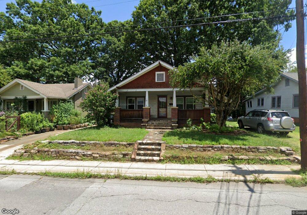
87 Louisiana Ave Asheville, NC 28806
West Asheville NeighborhoodEstimated Value: $336,452 - $412,000
2
Beds
1
Bath
1,176
Sq Ft
$321/Sq Ft
Est. Value
About This Home
This home is located at 87 Louisiana Ave, Asheville, NC 28806 and is currently estimated at $377,113, approximately $320 per square foot. 87 Louisiana Ave is a home located in Buncombe County with nearby schools including Hall Fletcher Elementary, Isaac Dickson Elementary, and Ira B Jones Elementary.
Ownership History
Date
Name
Owned For
Owner Type
Purchase Details
Closed on
Mar 31, 2006
Sold by
Betty Jean Haynie Revocable Trust
Bought by
Crowe Margaret Lyons
Current Estimated Value
Home Financials for this Owner
Home Financials are based on the most recent Mortgage that was taken out on this home.
Original Mortgage
$110,000
Interest Rate
6.25%
Mortgage Type
Fannie Mae Freddie Mac
Purchase Details
Closed on
Jan 18, 2006
Sold by
Haynie Jean Teague and Haynie Betty Jean
Bought by
Betty Jean Haynie Revocable Trust
Create a Home Valuation Report for This Property
The Home Valuation Report is an in-depth analysis detailing your home's value as well as a comparison with similar homes in the area
Home Values in the Area
Average Home Value in this Area
Purchase History
| Date | Buyer | Sale Price | Title Company |
|---|---|---|---|
| Crowe Margaret Lyons | $154,500 | None Available | |
| Betty Jean Haynie Revocable Trust | -- | None Available |
Source: Public Records
Mortgage History
| Date | Status | Borrower | Loan Amount |
|---|---|---|---|
| Previous Owner | Crowe Margaret Lyons | $110,000 |
Source: Public Records
Tax History Compared to Growth
Tax History
| Year | Tax Paid | Tax Assessment Tax Assessment Total Assessment is a certain percentage of the fair market value that is determined by local assessors to be the total taxable value of land and additions on the property. | Land | Improvement |
|---|---|---|---|---|
| 2025 | $2,233 | $164,600 | $95,800 | $68,800 |
| 2024 | $2,233 | $216,100 | $95,800 | $120,300 |
| 2023 | $2,233 | $216,100 | $95,800 | $120,300 |
| 2022 | $2,155 | $216,100 | $0 | $0 |
| 2021 | $2,155 | $216,100 | $0 | $0 |
| 2020 | $2,026 | $188,000 | $0 | $0 |
| 2019 | $2,026 | $188,000 | $0 | $0 |
| 2018 | $2,026 | $188,000 | $0 | $0 |
| 2017 | $2,045 | $110,300 | $0 | $0 |
| 2016 | $1,356 | $110,300 | $0 | $0 |
| 2015 | $1,356 | $110,300 | $0 | $0 |
| 2014 | $1,339 | $110,300 | $0 | $0 |
Source: Public Records
Map
Nearby Homes
- 197 Brucemont Cir
- 54 Louisiana Ave
- 60 Dorchester Ave
- 74 Brucemont Cir
- 141 Louisiana Ave
- 55 Herron Ave
- 18 Jarrett St
- 7 Mauricet Ln
- 27 Mauricet Ln
- 31 Oakwood St
- 5 Orrinel Way
- 37 Bryant St
- 18 Sand Hill Rd
- 30 Sand Hill Rd
- 20 Cloyes St
- 68 1/2 Nevada Ave
- 75 Nevada Ave
- 56 Brevard Rd
- 52 Boyd Ave
- 113 Burton St
- 95 Louisiana Ave
- 85 Louisiana Ave
- 97 Louisiana Ave
- 79 Louisiana Ave
- 193 Brucemont Cir
- 201 Brucemont Cir
- 187 Brucemont Cir
- 96 Louisiana Ave
- 75 Louisiana Ave
- 94 Louisiana Ave
- 203 Brucemont Cir
- 183 Brucemont Cir
- 105 Louisiana Ave
- 203 & 207 Brucemont Cir Unit 1 & 2
- 98 Louisiana Ave
- 80 Louisiana Ave Unit 2
- 74 Louisiana Ave
- 179 Brucemont Cir
- 104 Louisiana Ave
- 196 Brucemont Cir