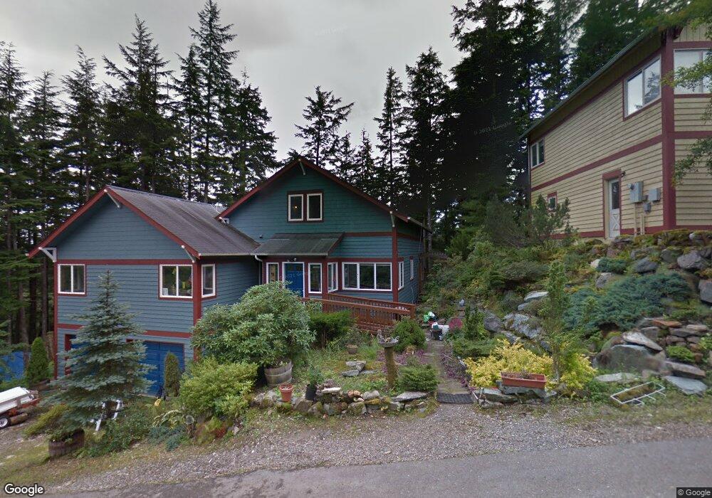
870 Miller Ridge Rd Ketchikan, AK 99901
Estimated Value: $661,744 - $821,000
4
Beds
3
Baths
2,460
Sq Ft
$295/Sq Ft
Est. Value
About This Home
This home is located at 870 Miller Ridge Rd, Ketchikan, AK 99901 and is currently estimated at $726,915, approximately $295 per square foot. 870 Miller Ridge Rd is a home with nearby schools including Ketchikan High School.
Ownership History
Date
Name
Owned For
Owner Type
Purchase Details
Closed on
Sep 15, 2016
Sold by
Alley Carol L and Alley Robert
Bought by
Finch Krista Lynn and Finch James Colby
Current Estimated Value
Home Financials for this Owner
Home Financials are based on the most recent Mortgage that was taken out on this home.
Original Mortgage
$360,000
Outstanding Balance
$287,554
Interest Rate
3.43%
Mortgage Type
New Conventional
Estimated Equity
$439,361
Create a Home Valuation Report for This Property
The Home Valuation Report is an in-depth analysis detailing your home's value as well as a comparison with similar homes in the area
Home Values in the Area
Average Home Value in this Area
Purchase History
| Date | Buyer | Sale Price | Title Company |
|---|---|---|---|
| Finch Krista Lynn | -- | Aetia |
Source: Public Records
Mortgage History
| Date | Status | Borrower | Loan Amount |
|---|---|---|---|
| Open | Finch Krista Lynn | $360,000 |
Source: Public Records
Tax History Compared to Growth
Tax History
| Year | Tax Paid | Tax Assessment Tax Assessment Total Assessment is a certain percentage of the fair market value that is determined by local assessors to be the total taxable value of land and additions on the property. | Land | Improvement |
|---|---|---|---|---|
| 2025 | $7,718 | $674,100 | $84,500 | $589,600 |
| 2024 | $7,336 | $646,300 | $79,900 | $566,400 |
| 2023 | $5,664 | $480,000 | $69,900 | $410,100 |
| 2022 | $4,548 | $385,400 | $55,900 | $329,500 |
| 2021 | $4,370 | $370,300 | $55,900 | $314,400 |
| 2020 | $4,236 | $365,200 | $55,900 | $309,300 |
| 2019 | $4,173 | $359,700 | $55,900 | $303,800 |
| 2018 | $4,097 | $353,200 | $55,900 | $297,300 |
| 2017 | $3,977 | $339,900 | $0 | $0 |
| 2016 | $2,317 | $198,000 | $0 | $0 |
| 2015 | -- | $321,300 | $0 | $0 |
| 2014 | -- | $321,300 | $0 | $0 |
Source: Public Records
Map
Nearby Homes
- 835 Harris St
- 772 Amundsen Way
- 800 BLK Miller Ridge Rd
- 930 Freeman St
- 930 & 936 Freeman St
- 647 Park Ave
- 0 N Legal Address Only Unit Long Arm - Moser Bay
- 0 N Legal Address Only Unit Lot 13, Stedman Stre
- 0 N Legal Address Only Unit 5100 Block of North
- 0 N Legal Address Only Unit L7-11B N Yorktown Dr
- Lots 7-11B N Yorktown Dr
- 464 Schoenbar Rd
- 1 Creek St
- 320 Bawden St Unit 613-614
- 320 Bawden St
- 320 Bawden St Unit 718
- 320 Bawden St Unit 509
- 764-766 Forest Ave
- 609-611 Hardcastle Way
- L8 B2 Gravina Island
- 858 Miller Ridge Rd
- 846 Miller Ridge Rd
- 898 Miller Ridge Rd
- 829 Miller Ridge Rd
- 765 Grant St
- 815 Miller Ridge Rd Unit 817
- 764 Amundsen Way
- 768 Amundson Way
- 816/818 Miller Ridge Rd
- 772 Amundsen Way Unit 3
- 755 Grant St
- 805 Miller Ridge Rd Unit 807
- 772 Amundson Way Unit 3
- 772 Amundson Way Unit 2
- 772 Amundson Way Unit 4
- 761 Grant St
- 833 Harris St
- 823 Harris St
- 764 Grant St
- 761 Harris St