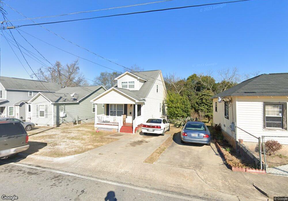
870 Mitchell St Macon, GA 31217
Estimated Value: $93,300 - $112,000
3
Beds
2
Baths
1,128
Sq Ft
$93/Sq Ft
Est. Value
About This Home
This home is located at 870 Mitchell St, Macon, GA 31217 and is currently estimated at $105,325, approximately $93 per square foot. 870 Mitchell St is a home located in Bibb County with nearby schools including Burdell Elementary School, Appling Middle School, and Northeast High School.
Ownership History
Date
Name
Owned For
Owner Type
Purchase Details
Closed on
Jan 16, 2014
Sold by
Georgia Behavioral Health Se
Bought by
Georgia Affordable Housing Solutions In
Current Estimated Value
Purchase Details
Closed on
Jun 23, 2011
Sold by
Macon-Bibb Co Land Bank Auth
Bought by
Georgia Behavioral Health Services Inc
Purchase Details
Closed on
Mar 23, 2010
Sold by
Macon Bibb County Economic Opportunity I
Bought by
The Macon Bibb County Land Bank Authorit
Purchase Details
Closed on
Jan 1, 2008
Sold by
Whitby Inc
Bought by
Macon Bibb County Eoc
Purchase Details
Closed on
Oct 23, 2006
Bought by
Whitby Inc
Create a Home Valuation Report for This Property
The Home Valuation Report is an in-depth analysis detailing your home's value as well as a comparison with similar homes in the area
Purchase History
| Date | Buyer | Sale Price | Title Company |
|---|---|---|---|
| Georgia Affordable Housing Solutions In | -- | -- | |
| Georgia Behavioral Health Services Inc | -- | -- | |
| The Macon Bibb County Land Bank Authorit | -- | None Available | |
| Macon Bibb County Eoc | $28,000 | -- | |
| Whitby Inc | -- | -- |
Source: Public Records
Tax History
| Year | Tax Paid | Tax Assessment Tax Assessment Total Assessment is a certain percentage of the fair market value that is determined by local assessors to be the total taxable value of land and additions on the property. | Land | Improvement |
|---|---|---|---|---|
| 2025 | -- | $37,247 | $2,420 | $34,827 |
| 2024 | -- | $32,664 | $1,320 | $31,344 |
| 2023 | $0 | $32,444 | $1,100 | $31,344 |
| 2022 | $796 | $20,954 | $1,548 | $19,406 |
| 2021 | $549 | $14,442 | $580 | $13,862 |
| 2020 | $522 | $13,056 | $580 | $12,476 |
| 2019 | $380 | $11,670 | $580 | $11,090 |
| 2018 | $120 | $11,670 | $580 | $11,090 |
| 2017 | $380 | $11,670 | $580 | $11,090 |
| 2016 | $0 | $11,670 | $580 | $11,090 |
| 2015 | -- | $11,670 | $580 | $11,090 |
| 2014 | -- | $14,481 | $619 | $13,862 |
Source: Public Records
Map
Nearby Homes
- 725 Schaeffer Place
- 972 Norris St
- 857 Mitchell St
- 751 Mitchell St
- 845 Norris St
- 722 Mitchell St
- 1059 Fort Hill St
- 774 Maynard St
- 1024 Clarks Ln
- 873 Fort Hill St
- 760 Cowan St
- 768 Maynard St
- 735 Maynard St
- 658 Pringle St
- 734 Fort Hill St
- 1244 Hall St
- 1215 Hawkinsville Ave
- 1392 Fort Hill St
- 955 Elder St
- 990 Center St
- 886 Mitchell St
- 860 Mitchell St
- 715 Schaeffer Place
- 850 Mitchell St
- 914 Mitchell St
- 846 Mitchell St
- 1021 Norris St
- 840 Mitchell St
- 1032 Joe Davis St
- 1059 Schaeffer Place
- 1065 Norris St
- 946 Norris St
- 1052 Joe Davis St
- 945 Maynard St
- 947 Schaeffer Place
- 939 Schaeffer Place
- 1054 Schaeffer Place
- 934 Norris St
- 1015 Maynard St
- 1062 Joe Davis St
Your Personal Tour Guide
Ask me questions while you tour the home.