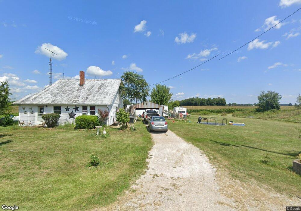
870 Shroll Rd Bucyrus, OH 44820
Estimated Value: $165,000 - $933,696
3
Beds
2
Baths
1,020
Sq Ft
$659/Sq Ft
Est. Value
About This Home
This home is located at 870 Shroll Rd, Bucyrus, OH 44820 and is currently estimated at $672,232, approximately $659 per square foot. 870 Shroll Rd is a home with nearby schools including Wynford Elementary School and Wynford High School.
Ownership History
Date
Name
Owned For
Owner Type
Purchase Details
Closed on
Sep 22, 2015
Sold by
Aidt Kenneth Carl and Aidt Darlene G
Bought by
Mutchler Michael B and Mutchle Carolyn S
Current Estimated Value
Home Financials for this Owner
Home Financials are based on the most recent Mortgage that was taken out on this home.
Original Mortgage
$316,600
Outstanding Balance
$188,735
Interest Rate
3.9%
Mortgage Type
Future Advance Clause Open End Mortgage
Estimated Equity
$483,497
Create a Home Valuation Report for This Property
The Home Valuation Report is an in-depth analysis detailing your home's value as well as a comparison with similar homes in the area
Home Values in the Area
Average Home Value in this Area
Purchase History
| Date | Buyer | Sale Price | Title Company |
|---|---|---|---|
| Mutchler Michael B | $457,600 | Acs Title Bucyrus |
Source: Public Records
Mortgage History
| Date | Status | Borrower | Loan Amount |
|---|---|---|---|
| Open | Mutchler Michael B | $316,600 |
Source: Public Records
Tax History Compared to Growth
Tax History
| Year | Tax Paid | Tax Assessment Tax Assessment Total Assessment is a certain percentage of the fair market value that is determined by local assessors to be the total taxable value of land and additions on the property. | Land | Improvement |
|---|---|---|---|---|
| 2024 | $1,147 | $30,520 | $15,230 | $15,290 |
| 2023 | $1,243 | $18,380 | $9,210 | $9,170 |
| 2022 | $927 | $18,380 | $9,210 | $9,170 |
| 2021 | $914 | $18,380 | $9,210 | $9,170 |
| 2020 | $819 | $16,000 | $9,210 | $6,790 |
| 2019 | $813 | $16,000 | $9,210 | $6,790 |
| 2018 | $852 | $16,000 | $9,210 | $6,790 |
| 2017 | $884 | $18,410 | $9,210 | $9,200 |
| 2016 | $741 | $63,840 | $54,640 | $9,200 |
| 2015 | $2,579 | $63,840 | $54,640 | $9,200 |
| 2014 | $1,568 | $38,130 | $28,930 | $9,200 |
| 2013 | $1,568 | $38,130 | $28,930 | $9,200 |
Source: Public Records
Map
Nearby Homes
- 308 Lincoln Hwy
- 1665 Lincoln Hwy
- 3056 Mccracken Rd
- 4432 Marion Melmore Rd
- 1773 Marion-Melmore Rd
- 275 Brentwood St
- 130 Brentwood St
- 2440 Wyandot Rd
- 885 W Perry St
- 441 Myers St
- 1792 Tiffin Rd
- 1112 Hillcrest Dr
- 1123 Hillcrest Dr
- 1149 Farmview Dr
- 2444 Spore Brandywine Rd
- 609 W Perry St
- 11700 Township Highway 133
- 1145 Lynne Ave
- 0 Lynne Ave
- 1315 Lynne Ave
- 975 Schroll Rd
- 3555 Knauss Rd
- 996 Schroll Rd
- 3564 Knauss Rd
- 990 Nevada Wynford Rd
- 900 Nevada Wynford Rd
- 828 Nevada Wynford Rd
- 909 Lincoln Hwy
- 887 Nevada Wynford Rd
- 929 Lincoln Hwy
- 769 Nevada Wynford Rd N
- 759 Nevada Wynford Rd N
- 0 Shroll Rd Unit 217043952
- 0 Shroll Rd Unit 217025946
- 0 Shroll Rd Unit 20124158
- 0 Shroll Rd Unit H120028
- TBD Shroll Rd
- 0 Shroll Rd Unit 9031889
- 0 Shroll Rd Unit 9040641
- 0 Shroll Rd Unit 4348992