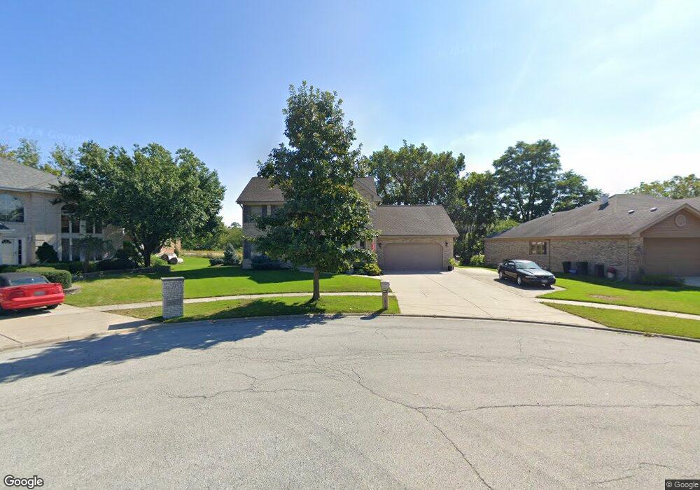
8711 Randolph Ct Woodridge, IL 60517
South Woodridge NeighborhoodEstimated Value: $592,919 - $642,000
--
Bed
1
Bath
2,411
Sq Ft
$256/Sq Ft
Est. Value
About This Home
This home is located at 8711 Randolph Ct, Woodridge, IL 60517 and is currently estimated at $616,980, approximately $255 per square foot. 8711 Randolph Ct is a home located in DuPage County with nearby schools including Prairieview Elementary School, Elizabeth Ide Elementary School, and Lakeview Jr High School.
Ownership History
Date
Name
Owned For
Owner Type
Purchase Details
Closed on
Nov 8, 2000
Sold by
Standard Bank & Trust Company
Bought by
Bandish Charles A and Bandish Maria R
Current Estimated Value
Home Financials for this Owner
Home Financials are based on the most recent Mortgage that was taken out on this home.
Original Mortgage
$281,253
Interest Rate
7.8%
Create a Home Valuation Report for This Property
The Home Valuation Report is an in-depth analysis detailing your home's value as well as a comparison with similar homes in the area
Home Values in the Area
Average Home Value in this Area
Purchase History
| Date | Buyer | Sale Price | Title Company |
|---|---|---|---|
| Bandish Charles A | $295,000 | -- |
Source: Public Records
Mortgage History
| Date | Status | Borrower | Loan Amount |
|---|---|---|---|
| Previous Owner | Bandish Charles A | $281,253 |
Source: Public Records
Tax History Compared to Growth
Tax History
| Year | Tax Paid | Tax Assessment Tax Assessment Total Assessment is a certain percentage of the fair market value that is determined by local assessors to be the total taxable value of land and additions on the property. | Land | Improvement |
|---|---|---|---|---|
| 2024 | $10,952 | $172,852 | $55,587 | $117,265 |
| 2023 | $10,506 | $158,900 | $51,100 | $107,800 |
| 2022 | $9,926 | $149,980 | $49,090 | $100,890 |
| 2021 | $9,164 | $148,270 | $48,530 | $99,740 |
| 2020 | $9,014 | $145,330 | $47,570 | $97,760 |
| 2019 | $8,736 | $139,440 | $45,640 | $93,800 |
| 2018 | $8,578 | $134,170 | $45,380 | $88,790 |
| 2017 | $8,284 | $129,110 | $43,670 | $85,440 |
| 2016 | $9,283 | $143,600 | $41,680 | $101,920 |
| 2015 | $9,156 | $135,100 | $39,210 | $95,890 |
| 2014 | $9,013 | $131,350 | $38,120 | $93,230 |
| 2013 | $9,161 | $130,730 | $37,940 | $92,790 |
Source: Public Records
Map
Nearby Homes
- 3145 Hillside Ln
- 8547 Harvest Ln
- 8843 Oxford St
- 8551 Sperry Ct
- 8498 Cornelia Ln
- 8543 Sperry Ct
- 8539 Sperry Ct
- 2845 87th St
- Danbury II Plan at The Townes at Farmingdale
- Brighton Plan at The Townes at Farmingdale
- Braeden Plan at The Townes at Farmingdale
- Campbell Plan at The Townes at Farmingdale
- 8497 Liberty Ln
- 1858 Fulton St
- 1850 Fulton St
- 1846 Fulton St
- 8538 Sperry Ct
- 8537 Chadwick Ct
- 8530 Sperry Ct
- 8541 Chadwick Ct
- 8713 Randolph Ct
- 8707 Randolph Ct
- 1615 87th St
- 8717 Randolph Ct
- 8705 Randolph Ct
- 8710 Randolph Ct
- 8721 Randolph Ct
- 8714 Randolph Ct
- 8706 Randolph Ct
- 20W325 87th St
- 8718 Randolph Ct
- 2987 87th St
- 8722 Randolph Ct
- 8709 Coventry Dr
- 8698 Wood Vale Dr
- 8715 Coventry Dr
- 8726 Randolph Ct
- 3130 87th St
- 8679 Wood Vale Dr
- 8705 Coventry Dr