Estimated Value: $250,000 - $271,527
3
Beds
2
Baths
1,728
Sq Ft
$151/Sq Ft
Est. Value
About This Home
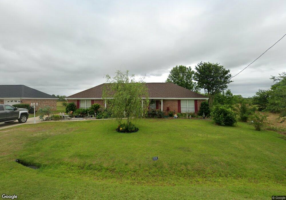
This home is located at 8714 Sherman Rd, Foley, AL 36535 and is currently estimated at $260,632, approximately $150 per square foot. 8714 Sherman Rd is a home located in Baldwin County with nearby schools including Magnolia School, Foley Middle School, and Foley High School.
Ownership History
Date
Name
Owned For
Owner Type
Purchase Details
Closed on
Jan 23, 2020
Sold by
Lipscomb Michael A and Lipscomb Alma S
Bought by
Lipscomb Alma Shelly and Beard Marcum
Current Estimated Value
Purchase Details
Closed on
May 8, 2019
Sold by
Lipscomb Michael and Lipscomb Alma
Bought by
Lipscomb Alma S and Lipscomb Michael A
Home Financials for this Owner
Home Financials are based on the most recent Mortgage that was taken out on this home.
Original Mortgage
$1
Interest Rate
4%
Purchase Details
Closed on
Feb 20, 2019
Sold by
Dollans Twenty
Bought by
Lipscomb Alma Shelly and Lipscomb Michael
Create a Home Valuation Report for This Property
The Home Valuation Report is an in-depth analysis detailing your home's value as well as a comparison with similar homes in the area
Home Values in the Area
Average Home Value in this Area
Purchase History
| Date | Buyer | Sale Price | Title Company |
|---|---|---|---|
| Lipscomb Alma Shelly | $45,400 | None Available | |
| Lipscomb Alma S | $44,800 | None Available | |
| Lipscomb Alma Shelly | $67,000 | None Available |
Source: Public Records
Mortgage History
| Date | Status | Borrower | Loan Amount |
|---|---|---|---|
| Previous Owner | Lipscomb Alma S | $1 |
Source: Public Records
Tax History Compared to Growth
Tax History
| Year | Tax Paid | Tax Assessment Tax Assessment Total Assessment is a certain percentage of the fair market value that is determined by local assessors to be the total taxable value of land and additions on the property. | Land | Improvement |
|---|---|---|---|---|
| 2024 | $649 | $24,780 | $4,000 | $20,780 |
| 2023 | $588 | $22,600 | $3,360 | $19,240 |
| 2022 | $497 | $19,360 | $0 | $0 |
| 2021 | $399 | $15,680 | $0 | $0 |
| 2020 | $385 | $15,340 | $0 | $0 |
| 2019 | $336 | $13,620 | $0 | $0 |
| 2018 | $331 | $13,440 | $0 | $0 |
| 2017 | $317 | $12,920 | $0 | $0 |
| 2016 | $296 | $12,180 | $0 | $0 |
| 2015 | $279 | $11,580 | $0 | $0 |
| 2014 | $284 | $11,740 | $0 | $0 |
| 2013 | -- | $11,220 | $0 | $0 |
Source: Public Records
Map
Nearby Homes
- Oxford Plan at Hawthorn
- Newlin Plan at Hawthorn
- Littleton Plan at Hawthorn
- 8453 Shannon's Mill Rd
- Ramsey Plan at Hawthorn
- 8409 Shannon's Mill Rd
- 15628 Rushbrook Ct
- 15636 Rushbrook Ct
- 8905 Sherman Rd
- 15623 Medway Ct
- 15602 Talus Ct
- 15577 Talus Ct
- 15585 Talus Ct
- 15435 Furlong Loop
- 15383 Furlong Loop
- 15397 Furlong Loop
- Dimaggio Plan at Sarah Farms
- 15334 Planters Ln
- Wagner Plan at Sarah Farms
- Mays Plan at Sarah Farms
- 8732 Sherman Rd
- 8746 Sherman Rd
- 8762 Sherman Rd
- 8782 Sherman Rd
- 8622 Sherman Rd
- 8822 Sherman Rd
- 0 Rushbrook Ct
- 8655 Shannons Mill Rd
- 8811 Sherman Rd
- 8826 Sherman Rd
- 8661 Shannons Mill Rd
- 8611 Lockridge Rd
- 15642 Rushbrook Ct
- 8661 Shannon's Mill Rd
- 8814 Gryder St
- 15643 Rushbrook Ct
- 8833 Sherman Rd
- 8842 Sherman Rd
- 8679 Shannons Mill Rd
- 8619 Lockridge Rd