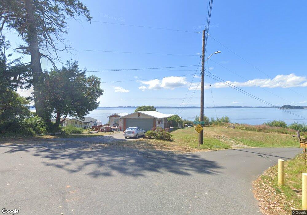
874 Brokaw Rd Camano Island, WA 98282
Estimated Value: $655,813 - $766,000
2
Beds
2
Baths
1,242
Sq Ft
$579/Sq Ft
Est. Value
About This Home
This home is located at 874 Brokaw Rd, Camano Island, WA 98282 and is currently estimated at $718,703, approximately $578 per square foot. 874 Brokaw Rd is a home located in Island County with nearby schools including Utsalady Elementary School, Port Susan Middle School, and Stanwood High School.
Ownership History
Date
Name
Owned For
Owner Type
Purchase Details
Closed on
Aug 9, 2018
Sold by
Thornlund Diana Marie and Mcdowell Vernon
Bought by
Mcdowell James Earl
Current Estimated Value
Home Financials for this Owner
Home Financials are based on the most recent Mortgage that was taken out on this home.
Original Mortgage
$300,000
Outstanding Balance
$260,538
Interest Rate
4.5%
Mortgage Type
Commercial
Estimated Equity
$458,165
Purchase Details
Closed on
Jun 29, 2018
Sold by
Thornlund Diane Marie and Thornlund Diana Marie
Bought by
Thornlund Diana Marie and Mcdowell James Earl
Home Financials for this Owner
Home Financials are based on the most recent Mortgage that was taken out on this home.
Original Mortgage
$300,000
Outstanding Balance
$260,538
Interest Rate
4.5%
Mortgage Type
Commercial
Estimated Equity
$458,165
Purchase Details
Closed on
May 15, 2009
Sold by
Thornlund Diane Marie and Estate Of Eloise Mcdowell
Bought by
Thornlund Diane Marie and Mcdowell Camano Island Cabin T
Create a Home Valuation Report for This Property
The Home Valuation Report is an in-depth analysis detailing your home's value as well as a comparison with similar homes in the area
Home Values in the Area
Average Home Value in this Area
Purchase History
| Date | Buyer | Sale Price | Title Company |
|---|---|---|---|
| Mcdowell James Earl | $300,000 | First American Title Ins Co | |
| Thornlund Diana Marie | -- | None Available | |
| Thornlund Diane Marie | -- | None Available |
Source: Public Records
Mortgage History
| Date | Status | Borrower | Loan Amount |
|---|---|---|---|
| Open | Mcdowell James Earl | $300,000 |
Source: Public Records
Tax History Compared to Growth
Tax History
| Year | Tax Paid | Tax Assessment Tax Assessment Total Assessment is a certain percentage of the fair market value that is determined by local assessors to be the total taxable value of land and additions on the property. | Land | Improvement |
|---|---|---|---|---|
| 2024 | $4,498 | $649,362 | $425,000 | $224,362 |
| 2023 | $4,498 | $587,748 | $360,000 | $227,748 |
| 2022 | $4,019 | $439,545 | $350,000 | $89,545 |
| 2021 | $4,120 | $434,087 | $290,000 | $144,087 |
| 2020 | $3,785 | $431,128 | $290,000 | $141,128 |
| 2019 | $3,158 | $390,884 | $290,000 | $100,884 |
| 2018 | $3,156 | $326,309 | $225,000 | $101,309 |
| 2017 | $2,755 | $302,160 | $200,000 | $102,160 |
| 2016 | $2,878 | $292,953 | $200,000 | $92,953 |
| 2015 | $2,960 | $294,585 | $200,000 | $94,585 |
| 2013 | -- | $297,844 | $200,000 | $97,844 |
Source: Public Records
Map
Nearby Homes
- 1042 Shorecrest Place
- 746 Maple Grove Rd
- 688 Gladstone Dr
- 1021 N Sunset Dr
- 938 NW Camano Dr
- 641 Maple Grove Rd
- 897 James Way
- 931 Karen Ann Dr
- 1048 Malvern Hills Dr
- 628 N Sunset Dr
- 366 Samanthia Ln
- 900 N Sunset Dr
- 435 NW Camano Dr
- 298 Echo Ridge Way
- 1048 Cassius Ct
- 435 Thumper Ln
- 250 Fay Ln
- 350 N Sunset Dr
- 345 Seaview Ct
- 329 Burke Dr
- 0 Blackberry Ln Unit 1116078
- 868 Brokaw Rd
- 869 Brokaw Rd
- 1019 Shorecrest Place
- 864 Brokaw Rd
- 1029 Blackberry Ln
- 859 W Brokaw Rd
- 1025 Shorecrest Place
- 1024 Shorecrest Place
- 860 Brokaw Rd
- 859 Brokaw Rd
- 1033 Blackberry Ln
- 0 Shorecrest Place
- 1015 Bayshore Dr
- 1029 Shorecrest Place
- 1037 Blackberry Ln
- 855 Brokaw Rd
- 1028 Shorecrest Place
- 1006 Bayshore Dr
- 1006 N Bayshore Dr