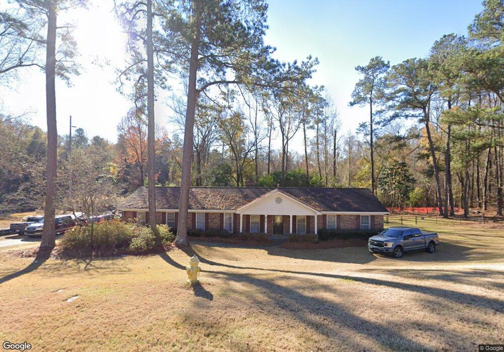
875 Pheasant Loop Columbus, GA 31907
Eastern Columbus NeighborhoodEstimated Value: $220,000 - $240,000
3
Beds
3
Baths
2,168
Sq Ft
$106/Sq Ft
Est. Value
About This Home
This home is located at 875 Pheasant Loop, Columbus, GA 31907 and is currently estimated at $230,058, approximately $106 per square foot. 875 Pheasant Loop is a home located in Muscogee County with nearby schools including St. Mary's Road Magnet Academy, Rothschild Leadership Academy, and Spencer High School.
Ownership History
Date
Name
Owned For
Owner Type
Purchase Details
Closed on
Aug 10, 2009
Sold by
Aldridge Terrell and Aldridge Misha P B
Bought by
Aldridge Terrell
Current Estimated Value
Home Financials for this Owner
Home Financials are based on the most recent Mortgage that was taken out on this home.
Original Mortgage
$60,000
Interest Rate
4.76%
Mortgage Type
New Conventional
Create a Home Valuation Report for This Property
The Home Valuation Report is an in-depth analysis detailing your home's value as well as a comparison with similar homes in the area
Home Values in the Area
Average Home Value in this Area
Purchase History
| Date | Buyer | Sale Price | Title Company |
|---|---|---|---|
| Aldridge Terrell | -- | None Available |
Source: Public Records
Mortgage History
| Date | Status | Borrower | Loan Amount |
|---|---|---|---|
| Closed | Aldridge Terrell | $60,000 |
Source: Public Records
Tax History Compared to Growth
Tax History
| Year | Tax Paid | Tax Assessment Tax Assessment Total Assessment is a certain percentage of the fair market value that is determined by local assessors to be the total taxable value of land and additions on the property. | Land | Improvement |
|---|---|---|---|---|
| 2025 | $1,107 | $69,000 | $17,260 | $51,740 |
| 2024 | $111 | $69,000 | $17,260 | $51,740 |
| 2023 | $418 | $69,000 | $17,260 | $51,740 |
| 2022 | $1,153 | $57,760 | $17,260 | $40,500 |
| 2021 | $1,146 | $58,448 | $17,260 | $41,188 |
| 2020 | $1,146 | $58,448 | $17,260 | $41,188 |
| 2019 | $1,152 | $58,448 | $17,260 | $41,188 |
| 2018 | $1,152 | $58,448 | $17,260 | $41,188 |
| 2017 | $1,157 | $58,448 | $17,260 | $41,188 |
| 2016 | $1,163 | $41,455 | $8,733 | $32,722 |
| 2015 | $466 | $41,455 | $8,733 | $32,722 |
| 2014 | $467 | $41,455 | $8,733 | $32,722 |
| 2013 | -- | $41,455 | $8,733 | $32,722 |
Source: Public Records
Map
Nearby Homes
- 811 Pheasant Loop
- 4939 Aaron Dr
- 4718 Velpoe Dr
- 849 Bunker Hill Rd
- 1025 Belmar St
- 906 Bunker Hill Rd
- 4201 Valley Crest Dr
- 5219 Argonne Dr
- 4965 Brightstar Ln
- 1225 Rowell St
- 780 Honey Do Ct
- 4422 Debolt Ct
- 4917 Brightstar Ln
- 1210 Bunker Hill Rd
- 5336 Gettysburg Way
- 4408 Ridgefield Dr
- 1513 Alamo Dr
- 5116 Magazine Ln
- 59 Apollo Dr
- 1238 Brandywine Dr
- 869 Pheasant Loop
- 870 Pheasant Loop
- 865 Pheasant Loop
- 881 Pheasant Loop
- 904 Quail Creek Dr
- 860 Pheasant Loop
- 900 Quail Creek Dr
- 876 Pheasant Loop
- 882 Pheasant Loop
- 859 Pheasant Loop
- 856 Quail Creek Dr
- 854 Pheasant Loop
- 852 Quail Creek Dr
- 849 Pheasant Loop
- 848 Pheasant Loop
- 846 Quail Creek Dr
- 4824 Velpoe Dr
- 4952 Aaron Dr
- 842 Pheasant Loop
- 4960 Aaron Dr