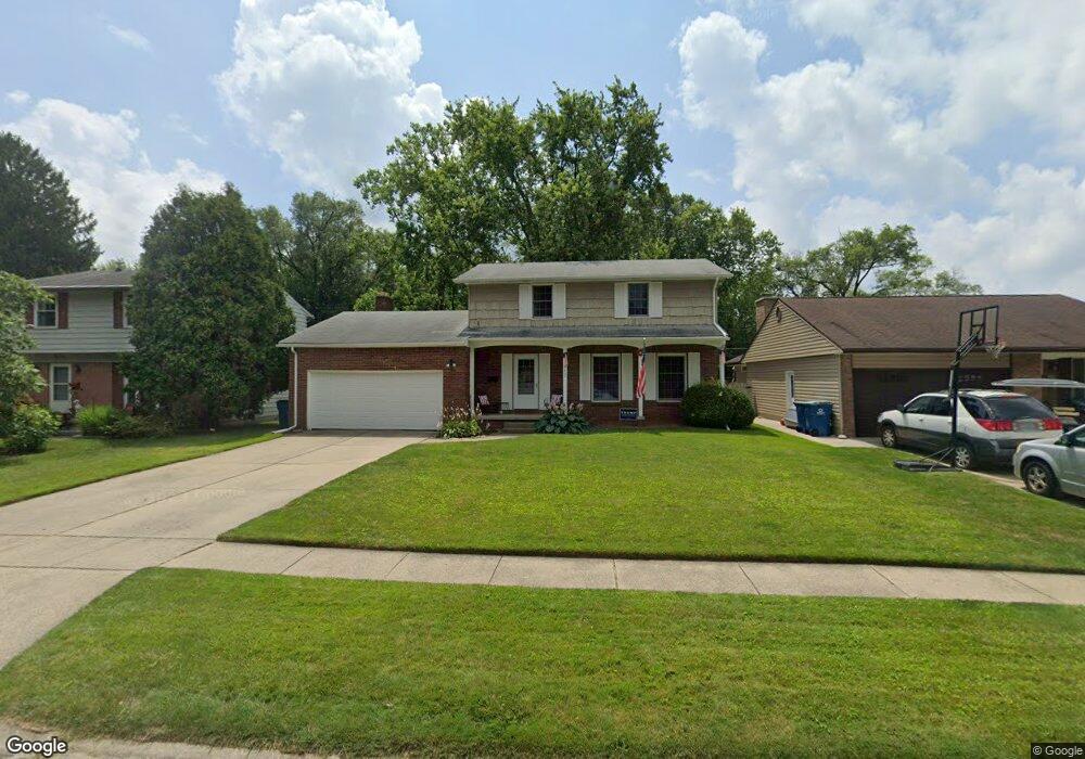
877 Maple Ln Waterville, OH 43566
Estimated Value: $274,000 - $307,000
4
Beds
3
Baths
1,872
Sq Ft
$157/Sq Ft
Est. Value
About This Home
This home is located at 877 Maple Ln, Waterville, OH 43566 and is currently estimated at $293,189, approximately $156 per square foot. 877 Maple Ln is a home located in Lucas County with nearby schools including Anthony Wayne High School, Lial Catholic School, and Monclova Christian Academy.
Ownership History
Date
Name
Owned For
Owner Type
Purchase Details
Closed on
Jun 7, 2022
Sold by
Ferdinand Seipel Jr
Bought by
Pokorny Matthew R and Pokorny Bethany L
Current Estimated Value
Purchase Details
Closed on
Nov 24, 2015
Sold by
Riverton Supply Inc
Bought by
Seipel Janet L
Purchase Details
Closed on
May 13, 2003
Sold by
Spieth Steven R and Spieth Kelly S
Bought by
Riverton Supply Inc
Purchase Details
Closed on
Nov 17, 1994
Sold by
Sutberry Charles E
Bought by
Spieth Steven R and Spieth Kelly S
Create a Home Valuation Report for This Property
The Home Valuation Report is an in-depth analysis detailing your home's value as well as a comparison with similar homes in the area
Home Values in the Area
Average Home Value in this Area
Purchase History
| Date | Buyer | Sale Price | Title Company |
|---|---|---|---|
| Pokorny Matthew R | $199,000 | Squillante David G | |
| Seipel Janet L | -- | None Available | |
| Riverton Supply Inc | $165,000 | -- | |
| Spieth Steven R | $105,000 | -- |
Source: Public Records
Tax History
| Year | Tax Paid | Tax Assessment Tax Assessment Total Assessment is a certain percentage of the fair market value that is determined by local assessors to be the total taxable value of land and additions on the property. | Land | Improvement |
|---|---|---|---|---|
| 2025 | -- | $81,130 | $12,320 | $68,810 |
| 2024 | $2,000 | $81,130 | $12,320 | $68,810 |
| 2023 | $3,719 | $68,110 | $10,255 | $57,855 |
| 2022 | $3,755 | $68,110 | $10,255 | $57,855 |
| 2021 | $3,989 | $68,110 | $10,255 | $57,855 |
| 2020 | $3,748 | $57,295 | $8,435 | $48,860 |
| 2019 | $3,460 | $57,295 | $8,435 | $48,860 |
| 2018 | $3,417 | $57,295 | $8,435 | $48,860 |
| 2017 | $3,192 | $49,455 | $10,150 | $39,305 |
| 2016 | $3,160 | $141,300 | $29,000 | $112,300 |
| 2015 | $3,026 | $141,300 | $29,000 | $112,300 |
| 2014 | $3,015 | $48,480 | $9,940 | $38,540 |
| 2013 | $3,015 | $48,480 | $9,940 | $38,540 |
Source: Public Records
Map
Nearby Homes
- 42 N Melody Ln
- 132 Wilkshire Dr
- 1195 Farnsworth Rd
- 305 Ridgepoint Cir
- 22 S 5th St
- 1591 Southridge Dr
- 1307 Limerick Ln
- 1174 Riley Ln
- 214 N 2nd St
- 1335 Limerick Ln
- 792 Wilkshire Dr
- 1347 Limerick Ln
- 1383 Limerick Ln
- 1391 Limerick Ln
- 938 Wilkshire Dr
- 8109 Bridgehampton Dr
- 410 Overlook Dr
- 1800 Caleb Ct
- 1812 Caleb Ct
- 1860 Caleb Ct
Your Personal Tour Guide
Ask me questions while you tour the home.