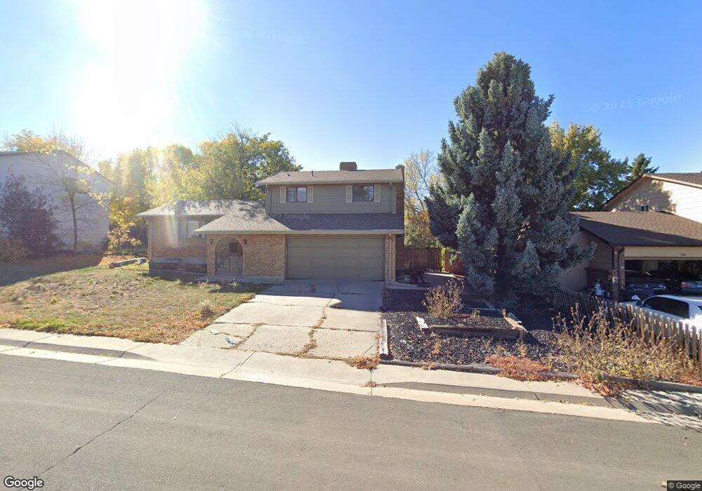
878 Hamal Dr Lone Tree, CO 80124
Estimated Value: $554,717 - $562,000
3
Beds
3
Baths
2,288
Sq Ft
$244/Sq Ft
Est. Value
About This Home
This home is located at 878 Hamal Dr, Lone Tree, CO 80124 and is currently estimated at $558,359, approximately $244 per square foot. 878 Hamal Dr is a home located in Douglas County with nearby schools including Acres Green Elementary School, Cresthill Middle School, and Highlands Ranch High School.
Ownership History
Date
Name
Owned For
Owner Type
Purchase Details
Closed on
Jul 25, 1997
Sold by
Pongonis Robert G and Pongonis Linda
Bought by
Pongonis Robert G
Current Estimated Value
Home Financials for this Owner
Home Financials are based on the most recent Mortgage that was taken out on this home.
Original Mortgage
$116,250
Outstanding Balance
$14,650
Interest Rate
7.6%
Estimated Equity
$543,709
Purchase Details
Closed on
Feb 1, 1980
Sold by
Unavailable
Bought by
Unavailable
Create a Home Valuation Report for This Property
The Home Valuation Report is an in-depth analysis detailing your home's value as well as a comparison with similar homes in the area
Home Values in the Area
Average Home Value in this Area
Purchase History
| Date | Buyer | Sale Price | Title Company |
|---|---|---|---|
| Pongonis Robert G | -- | North American Title | |
| Unavailable | $71,400 | -- |
Source: Public Records
Mortgage History
| Date | Status | Borrower | Loan Amount |
|---|---|---|---|
| Open | Pongonis Robert G | $116,250 |
Source: Public Records
Tax History
| Year | Tax Paid | Tax Assessment Tax Assessment Total Assessment is a certain percentage of the fair market value that is determined by local assessors to be the total taxable value of land and additions on the property. | Land | Improvement |
|---|---|---|---|---|
| 2025 | $3,144 | $34,190 | $6,830 | $27,360 |
| 2024 | $3,144 | $37,940 | $7,980 | $29,960 |
| 2023 | $3,177 | $37,940 | $7,980 | $29,960 |
| 2022 | $2,374 | $26,660 | $6,770 | $19,890 |
| 2021 | $2,468 | $26,660 | $6,770 | $19,890 |
| 2020 | $2,369 | $26,210 | $6,390 | $19,820 |
| 2019 | $2,377 | $26,210 | $6,390 | $19,820 |
| 2018 | $1,889 | $22,310 | $5,570 | $16,740 |
| 2017 | $1,920 | $22,310 | $5,570 | $16,740 |
| 2016 | $1,686 | $19,190 | $3,930 | $15,260 |
| 2015 | $1,724 | $19,190 | $3,930 | $15,260 |
| 2014 | $772 | $16,080 | $3,980 | $12,100 |
Source: Public Records
Map
Nearby Homes
- 789 Mercury Cir
- 13226 Canopus Dr
- 8852 Chestnut Hill Ln
- 6945 Mountain Brush Cir
- 9314 Wiltshire Dr
- 8049 Sweet Water Rd
- 7057 Chestnut Hill St
- 7191 Palisade Dr
- 8159 Lodgepole Trail
- 6823 Edgewood Place
- 9466 Wiltshire Dr
- 9377 Newport Ln
- 9320 Miles Dr
- 7459 La Quinta Place
- 9390 Yale Ln
- 9631 Kemper Dr
- 9395 Princeton Cir
- 181 Dianna Dr
- 8666 Ainsdale Ct Unit 12B
- 9366 Cornell Cir
Your Personal Tour Guide
Ask me questions while you tour the home.