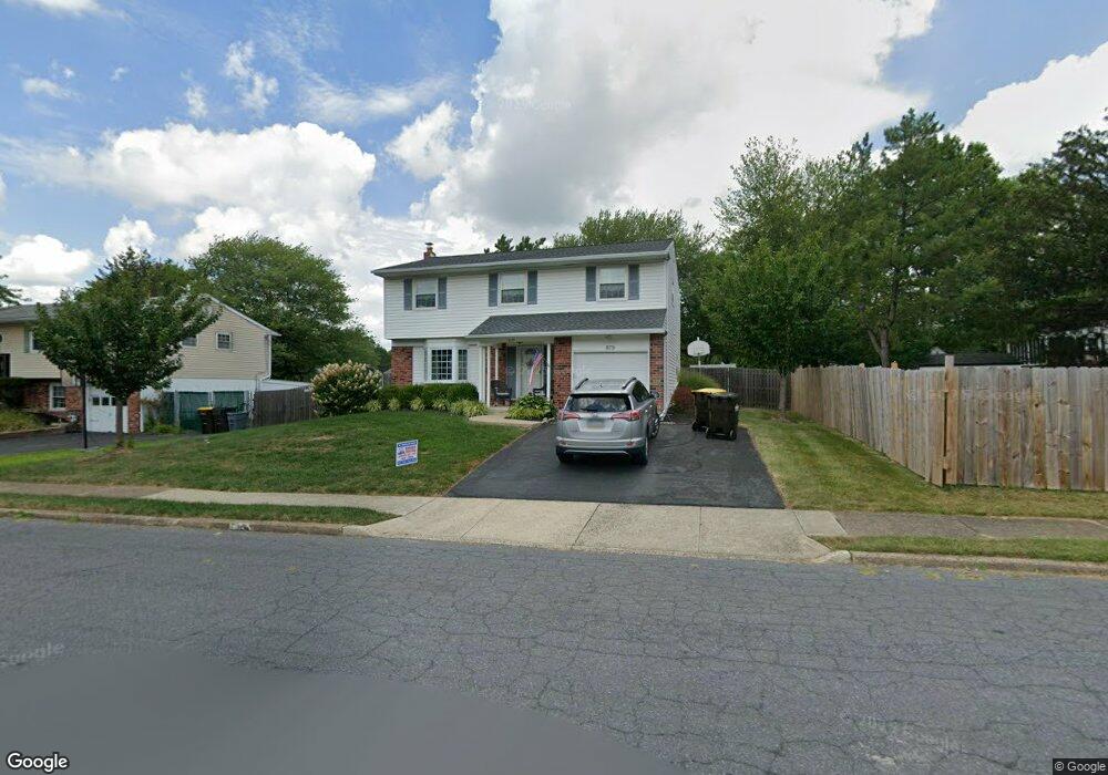
879 Gettysburg Dr Lansdale, PA 19446
Estimated Value: $504,000 - $542,449
4
Beds
3
Baths
2,200
Sq Ft
$240/Sq Ft
Est. Value
About This Home
This home is located at 879 Gettysburg Dr, Lansdale, PA 19446 and is currently estimated at $527,112, approximately $239 per square foot. 879 Gettysburg Dr is a home located in Montgomery County with nearby schools including Knapp Elementary School, Penndale Middle School, and North Penn Senior High School.
Ownership History
Date
Name
Owned For
Owner Type
Purchase Details
Closed on
Jul 28, 2012
Bought by
Ortwein Monaghan Patricia A
Current Estimated Value
Purchase Details
Closed on
Jan 31, 2003
Sold by
Pickles Linda A and Pickles Albert N
Bought by
Ortwein Patricia A and Monaghan Timothy P
Purchase Details
Closed on
Nov 19, 2001
Sold by
Buguliskis Linda A and Pickles Albert N
Bought by
Pickles Albert N and Pickles Linda A
Purchase Details
Closed on
Sep 18, 1997
Sold by
Herrick David N and Herrick Ann M
Bought by
Bugliskis Linda A and Pickles Albert N
Create a Home Valuation Report for This Property
The Home Valuation Report is an in-depth analysis detailing your home's value as well as a comparison with similar homes in the area
Home Values in the Area
Average Home Value in this Area
Purchase History
| Date | Buyer | Sale Price | Title Company |
|---|---|---|---|
| Ortwein Monaghan Patricia A | -- | -- | |
| Ortwein Patricia A | $221,500 | -- | |
| Monaghan Timothy P | $221,500 | -- | |
| Ortwein Patricia A | $221,500 | -- | |
| Pickles Albert N | -- | -- | |
| Bugliskis Linda A | $140,000 | -- |
Source: Public Records
Tax History Compared to Growth
Tax History
| Year | Tax Paid | Tax Assessment Tax Assessment Total Assessment is a certain percentage of the fair market value that is determined by local assessors to be the total taxable value of land and additions on the property. | Land | Improvement |
|---|---|---|---|---|
| 2025 | $6,552 | $155,750 | -- | -- |
| 2024 | $6,552 | $155,750 | -- | -- |
| 2023 | $6,128 | $155,750 | $0 | $0 |
| 2022 | $5,934 | $155,750 | $0 | $0 |
| 2021 | $5,692 | $155,750 | $0 | $0 |
| 2020 | $5,521 | $155,750 | $0 | $0 |
| 2019 | $5,429 | $155,750 | $0 | $0 |
| 2018 | $1,457 | $155,750 | $0 | $0 |
| 2017 | $5,068 | $155,750 | $0 | $0 |
| 2016 | $5,007 | $155,750 | $0 | $0 |
| 2015 | $4,919 | $155,750 | $0 | $0 |
| 2014 | $4,647 | $155,750 | $0 | $0 |
Source: Public Records
Map
Nearby Homes
- 502 Williamsburg Rd
- 964 Knapp Rd
- 825 Monticello Place
- 873 Lombardy Dr
- 3103 Hemmingway Dr
- 3406 Elizabeths Ct
- 1506 Naomis Ct
- 1101 Barbaras Ct
- 220 Hampton Green Dr
- 115 Castle Dr
- 1114 W Thomas Rd
- 102 Gwynmont Dr
- 1014 Lansdale Ave
- 1103 Lansdale Ave
- 117 Gwynmont Dr
- 1107 Lansdale Ave
- 1204 Vilsmeier Rd
- 19 Wexford Dr
- 323 Edgewood Ave
- 37 Shannon Rd
- 873 Gettysburg Dr
- 602 Williamsburg Rd
- 608 Williamsburg Rd
- 867 Gettysburg Dr
- 880 Concord Place
- 874 Concord Place
- 614 Williamsburg Rd
- 880 Gettysburg Dr
- 868 Concord Place
- 874 Gettysburg Dr
- 861 Gettysburg Dr
- 552 Williamsburg Rd
- 868 Gettysburg Dr
- 862 Concord Place
- 855 Gettysburg Dr
- 607 Williamsburg Rd
- 862 Gettysburg Dr
- 613 Williamsburg Rd
- 625 Williamsburg Rd
- 601 Williamsburg Rd